

Tropical Western Pacific’s Rich Legacy of Data Lives On
Published: 28 July 2022
ARM’s first overseas atmospheric observatory, which operated from 1996 to 2014, also spurred international collaborations
This is the third article in the yearlong “ARM30” series of stories on the evolution of ARM―its data, sites, science missions, field campaigns, and people.
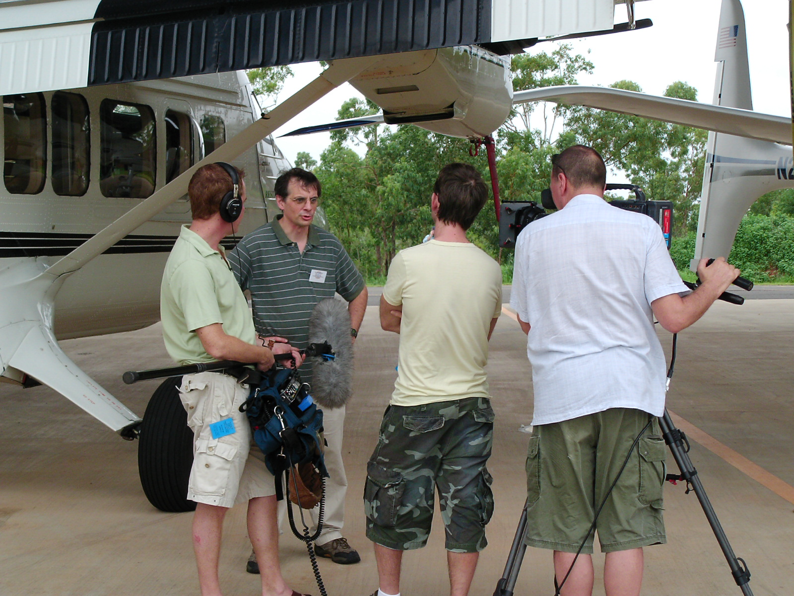
One day in September 1996, atmospheric scientist Jim Mather looked out the window of a small plane and saw Manus Island loom into sight.
This green-peaked dot of land in the Pacific Ocean, just north of Australia, was a narrow strip of bright sand and lush thickets of rainforest beyond.
Mather was heading there for a site installation on behalf of a U.S. Department of Energy (DOE) entity that set out to operate atmospheric observatories in climate-critical regions of the world.
In 2022, DOE’s Atmospheric Radiation Measurement (ARM) user facility marks its 30th year of collecting continuous data on clouds, solar radiation, and other features behind the fluid drama of weather and climate.
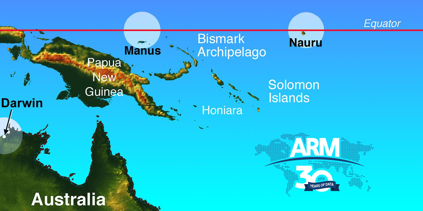
Manus became ARM’s first international observatory in 1996. It was the first of three linked sites known collectively as the Tropical Western Pacific (TWP).
Five years earlier, ARM experts earmarked the region as one of the world’s most climatically significant.
The region is within what scientists call the tropical warm pool. This vast tract of sea, which links the western Pacific and eastern Indian oceans, has the warmest water on Earth.
“The tropics is the heat source for the global climate system,” says Mather, now ARM’s technical director. “It is where incoming solar energy is maximum, and the surface temperatures of the sea are maximum. So, you have this maximum in convective activity, which drives a lot of the global circulation. The poleward transfer of energy is driven by this convection.”
At the same time, he adds, “that convection and the processes controlling it were very little understood.”
TWP operations fully ceased in 2014, but its rich data and landmark field campaigns still fuel a steady storm of publications. (TWP data remain freely available online through ARM Data Discovery.)
The Evolution of the TWP
Manus, part of Papua New Guinea, is “in the region of maximum convective activity, in the heart of the warm pool,” says Mather.
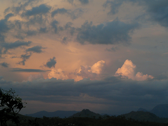
The island is 2 degrees south of the equator. The weather is hot, humid, rainy, and—as the locals say—“thundery.”
For such a small place (80% the size of Rhode Island), Manus is crowded with at least two dozen native dialects, including Hermit, Bipi, and Pak-Tong. The only common linguistic feature is a distinctive trill.
When Mather flew into this picture-book place in 1996, he was barely two years into his profession. From Mather’s home in State College, Pennsylvania, flying to Manus took 48 hours of what he describes as “constant motion.”
ARM’s first data on record from Manus are date-stamped soon after Mather landed there—on October 10, 1996.
Before long, also on business, Mather flew into an island hundreds of miles to the east called Nauru. Its western shore is a rim of paradisical golden beach and blue sea. But its interior is a moonscape of sinkholes, caves, and needle-like karst, left over from generations of phosphate mining.
TWP operations at Nauru started in 1998.
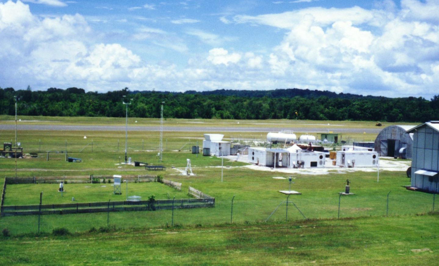
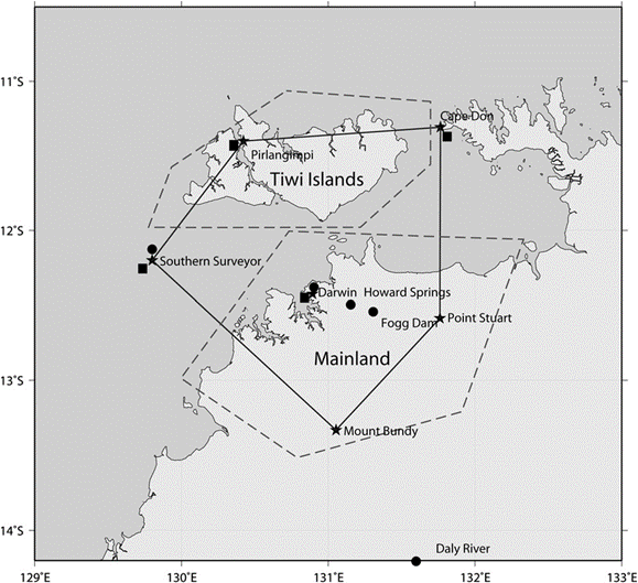
In 2002, ARM began operating a third TWP site in Darwin, Australia―largely for the city’s value as a historically instrumented weather site that also offered logistical advantages.
Addressing a Key Data Need
Manus and Nauru represent different atmospheric states within the tropical warm pool.
ARM was also drawn to Manus and Nauru because, until a few decades ago, the region was dramatically lacking in atmospheric data.
In addition, the region is a bellwether for climate change.
The region spurs moist convective atmospheric turbulence marked by vortex-like “hot towers” of clouds. They can rise to 20,000 meters (about 12.5 miles) or, in some cases, much higher. All this creates air circulations that influence weather and climate around the globe, including a seasonal spawn of cyclones.
More latent heat to feed the “hot towers” has meant more cyclones, altered rainfall patterns, and changes to a tropical weather pattern called the Madden-Julian Oscillation (MJO).
The MJO is a primary mode of air circulation in the tropics. In its active phase, the MJO generates a high percentage of tropical cyclones.
Peter May, a veteran Australian meteorologist instrumental in setting up the TWP’s Darwin site, compared the MJO to “a wave of thunderstorms that propagates all the way around the globe.”
Enduring Value
A 2016 paper discusses the TWP’s history, and its authors represent a brief who’s who of the observatory:
- Lead author Chuck Long, who passed away in 2019, was the TWP site scientist from 1999 to 2015.
- Tom Ackerman, now retired from the University of Washington, was the TWP’s first site scientist and later the chief scientist for ARM.
- Mather, an Ackerman acolyte at Pennsylvania State University, joined ARM and the TWP site science team in 1994.
In 2009 and 2010, a $60 million infusion of DOE funding allowed ARM to enhance its store of TWP instruments, especially scanning radars. This allowed an expanded spatial view and a movement beyond ARM’s traditional, vertically pointing “soda straw” view of the atmosphere.
A few years later, citing the challenges of maintaining advanced atmospheric instrumentation in remote tropical locations, ARM began to wind down TWP operations. Nauru shut down in August 2013, Manus one year later, and Darwin in December 2014.
Despite the closure, peer-reviewed publications that cite TWP data (571 so far) have maintained their lively pace since 1998—the first year of a jump into double digits—right through 2021.
TWP data were key in early studies of the MJO, including a 2013 paper co-authored by Sally McFarlane, then a research scientist at Pacific Northwest National Laboratory (PNNL) in Washington state. She is now DOE’s program manager for ARM.
The paper used cloud, precipitation, humidity, and other Manus Island measurements from 13 MJO cycles over six winters. From these data, the researchers created a single composite event that (among other things) provided a unique daily view of cloud processes.
McFarlane calls the TWP’s 18-year legacy of data, especially from Manus and Nauru, “unprecedented to have. That long an observational record, in those kinds of remote and hard-to-access locations, in the middle of the tropical warm pool, is an amazing data resource still.”
TWP Inspiration
TWP planning began in May 1992, the same month that ARM’s first observatory, the Southern Great Plains, began collecting data in Oklahoma.
The TWP’s main mission was to measure radiation balance and record surface meteorology and cloud properties. Its science tasks are outlined in a 1999 paper led by Ackerman. His co-authors included the first TWP site managers, Bill Clements and Fairley Barnes, who have since retired from Los Alamos National Laboratory in New Mexico.
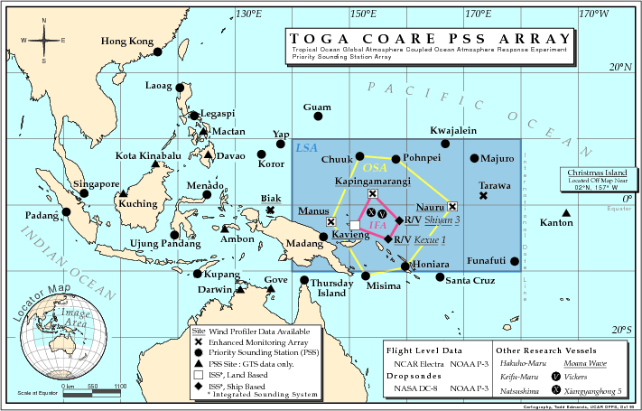
A main influence on the TWP was the Tropical Ocean Global Atmosphere – Coupled Ocean Atmosphere Response Experiment (TOGA-COARE), which in 1992 and 1993 set out to study how the coupled ocean-atmosphere system affected global climate change.
This field campaign drew almost 1,200 researchers from 20 countries, sponsored 125 research flights, and launched about 12,000 radiosondes across a vast swath of the western Pacific.
While planning for the TWP, ARM participated in TOGA-COARE by emplacing a remote-sensing facility in Kavieng, Papua New Guinea. The site provided radiation data and engendered one of ARM’s first field campaigns, the Pilot Radiation Observation Experiment (PROBE).
Overall, the TOGA-COARE/PROBE experience gave TWP planners insights into scientific ideas, deployment concepts, and where a first TWP site should go.
A Manus Foothold
The Maritime Continent, which sits within the tropical warm pool, is dotted with thousands of islands of different sizes and heights.
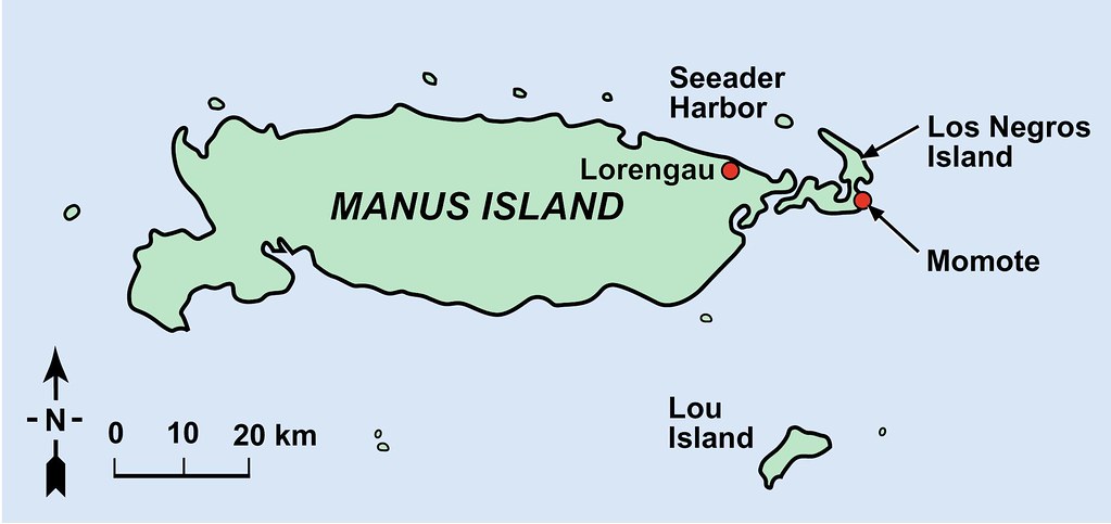
ARM chose Manus, a moderate-size island on the eastern edge of the Maritime Continent, as a place that could represent how convection was distributed in the region.
It also became the first test of a scheme for deploying instruments called the Atmospheric and Radiation Cloud Station (ARCS). Based on lessons learned during PROBE, this compact cluster of instruments, shipped in sea containers, was meant to be portable, self-contained, and robust in a harsh and humid tropical environment.
In 1996, for Manus, the first ARCS was packed up at Sandia National Laboratories in New Mexico, then unpacked and beta-tested dockside in San Diego, California.
Data of Immediate Interest
Data from Manus were of immediate interest to scientists studying cloud regimes, the MJO, and surface radiation budgets.
The ARCS, with input from NOAA and the National Center for Atmospheric Research, became the direct precursor of the container-based portable observatories called the ARM Mobile Facilities (AMF).
The first international AMF deployment was to Niger for a 2006–2007 field campaign called Radiative Divergence using AMF, GERB, and AMMA Stations (RADAGAST). Researchers investigated the divergence in measurements between surface and atmospheric absorption of solar radiation.
ARM sent an AMF to Gan Island in the Maldives for the 2011–2012 ARM Madden-Julian Oscillation Experiment (AMIE), which focused on the mechanisms that control tropical convection. Long led concurrent AMIE campaigns on Gan and Manus.
In models, Manus is where the MJO starts to weaken. That made the island an important data counterpoint to Gan, where the MJO starts its eastward propagation.
The AMIE-Gan and AMIE-Manus campaigns, boosted by new ARM instrumentation, benefited from growing capabilities at the TWP in its second decade of operation.
Nauru Goes Up
By November 1998, ARM had established its second TWP site. Nauru Island is a speck of land barely 5 kilometers (3 miles) in diameter. But it is on the eastern edge of the tropical warm pool and was thought to be an important locus of variability to conditions at Manus.
Finding a place for the ARCS, says Mather, was a serious challenge on a tiny island pinched for real estate. The eventual site on Nauru’s western shore had to be built up with crushed coral.
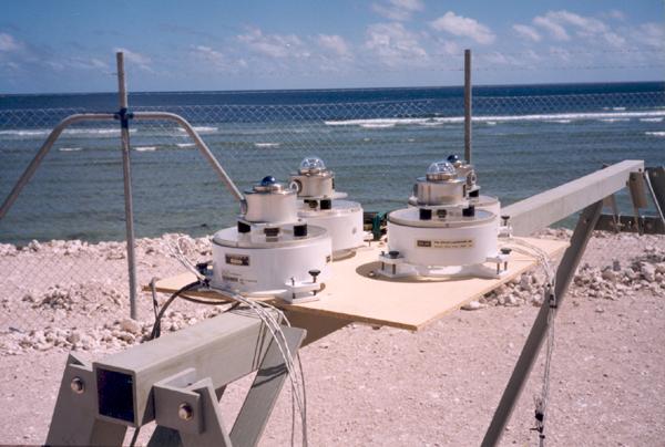
Instruments along Nauru’s western shore included radiometers that measured ultraviolet radiation from the sun.
As they did with Manus, scientists took immediate interest in data from Nauru. There was a spate of papers on albedo (reflectivity), humidity, tropical cirrus clouds (which sometimes form at the top of cyclones), and the island’s unusual variabilities―in both cloud cover and outgoing longwave radiation.
The latter was a special interest of McFarlane’s. She led a 2013 paper that compared cloud radiative effects at all three TWP sites.
An Island Effect
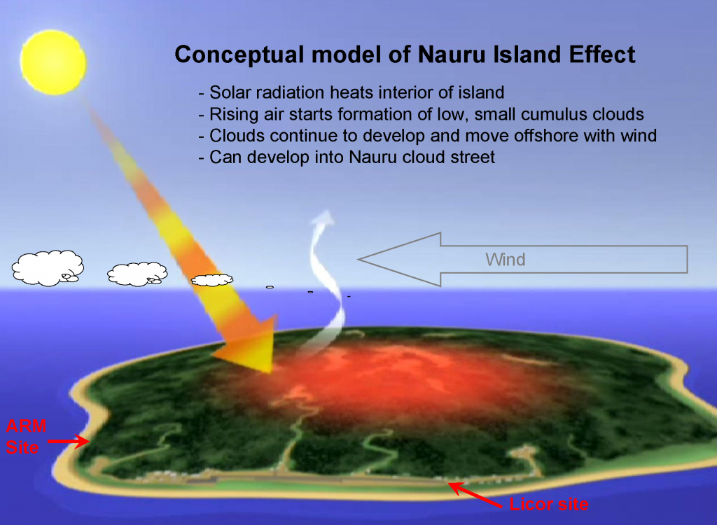
McFarlane and Long also wrote a series of papers between 2001 and 2012 on what is called the Nauru island effect. That happens when solar heating from the island’s barren interior creates “streets” of clouds that can persist for up to 200 kilometers (124 miles) away.
Nauru was noted for the Nauru99 field campaign, an international collaboration in June and July 1999. Involved were research ships from the United States and Japan, as well as a novel array of maritime buoys.
Observations during Nauru99 inspired ARM’s Nauru Island Effect Study (NIES), led by Long from 2001 to 2003.
That a tiny island was making its own clouds (and affecting data from surface instruments) “was something we learned from,” says McFarlane, “and something we considered for other deployments in the future.”
Adding Darwin
Adding Darwin, Australia, to the TWP family in 2002 was seen as an opportunity with many facets:
- the possibility of more airborne measurements
- the synergy of Darwin’s century of meteorological data
- the Australian Bureau of Meteorology’s (BOM) dual-polarization scanning radar and wind profilers
- a logistical base with abundant power, supply lines, and technical expertise
- the city’s annual monsoon season.
Unlike islands within the tropical warm pool, Darwin is influenced but not dominated by the MJO. Nor is it dominated by the El Niño-Southern Oscillation (ENSO), which is marked by irregular winds and shifts in ocean temperature.
“The MJO and ENSO are both important for Darwin,” says May. “We also argued that sampling a classic monsoon environment was important in terms of climate and weather of significant tropical cloud systems.”
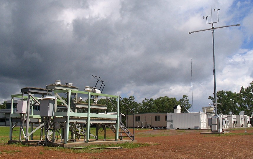
Data collection at ARM’s Darwin site began in March 2002. Its airport location was next to a key BOM facility.
“We clearly had the best instrumented location anywhere in the tropics in the world,” says May, who until 2020 was head of research at BOM.
In 2003, with ARM cloud radars and micropulse lidars humming into high gear, planning started for an ambitious ARM field campaign.
What became the Tropical Warm Pool – International Cloud Experiment (TWP-ICE) studied the properties and life cycles of tropical convective systems. Important streams of TWP-ICE data came from Darwin.
May was named the TWP-ICE lead scientist. Mather took on the lead scientist role for ARM.
TWP-ICE and Friends
TWP-ICE―which involved observations from land, ship, aircraft, and radiosonde―took place in January and February 2006.
The timing was right.
TWP-ICE coincided with two European-sponsored campaigns: Aerosol and Chemical Transport in Tropical Convection (ACTIVE) and Stratospheric-Climate Links with Emphasis on the Upper Troposphere and Lower Stratosphere (SCOUT-O3).
ACTIVE and SCOUT-O3 had different but related science goals to TWP-ICE.
TWP-ICE focused on maritime convection linked to active monsoon periods and creating a data set that could be used for model validation and satellite data verification.
ACTIVE investigated aerosol processes. SCOUT-O3 looked at the exchange of water vapor, aerosols, and chemicals between the troposphere and the stratosphere.
Thanks to the diversity of measurements, researchers improved understanding of convective clouds, gravity waves, precipitation, and satellite evaluation.
Researchers used TWP-ICE data to publish insights on the boundary layer, its diurnal cycle, and how it relates to clouds and radiation. That was the subject of a 2012 paper led by May. His co-authors were Long and radar scientist Alain Protat, a prominent voice in Australian meteorology.
Campaign as Crucible
The TWP was a crucible for many scientists in the early phases of their careers using ARM data. McFarlane and Mather are two.
TWP-ICE itself was a crucible.
Adam Varble, now at PNNL, was part of 13 papers related to TWP-ICE. Among them, he led a 2011 study on modeling cloud and precipitation structure.
Scott Collis, an Australian now at Argonne National Laboratory in Illinois, used TWP-ICE data in a 2013 paper with Protat and May on storm updraft velocities.
May led the go-to summary paper on TWP-ICE, published in 2008.
In an interview, he noted the special utility of polarimetric radars during the campaign, which drew in data from horizontal and vertical planes and yielded a three-dimensional view of tropical convection.
May and Mather pointed to another unique TWP-ICE data set: sounding data of a high time resolution, culled from a five-site network around Darwin that covered about 200 kilometers (124 miles) in diameter.
Most weather services around the world might launch one radiosonde every 12 or 24 hours, says May, but TWP-ICE launched every three hours.
TWP-ICE was also unusual, he adds, because two research aircraft flew the same transects at different altitudes to sample cirrus clouds at different heights in the same time window.
“Those sorts of observations are like gold,” he says. “They’re very expensive and hard to get. But they are used and used and used.”
That’s true of the TWP in general, says May. “Those legacy data sets keep on giving.”
Legacies of Collaboration
Another aspect of the TWP keeps on giving: the collaborations it engendered between atmospheric scientists in the United States and Australia.
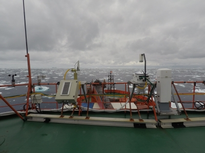
Two prominent ARM field campaigns in the Southern Ocean pivoted from bases in Australia and used Australian assets.
The Macquarie Island Cloud and Radiation Experiment (MICRE) ran from 2016 to 2018 to investigate Southern Ocean clouds, which are little understood and poorly represented in models.
In 2017 and 2018, the Measurements of Aerosols, Radiation, and Clouds over the Southern Ocean (MARCUS) campaign collected data aboard an Australian Antarctic supply vessel.
U.S.-Australian collaboration is still lively.
In April 2022, University of Utah researcher Gerald “Jay” Mace, an ARM/TWP veteran, boarded the Australian research vessel R/V Investigator on a two-week trip to service automated buoys in the Southern Ocean Time Series Observatory.
“I also supplied radiosondes and my microwave radiometer for the voyage,” says Mace, who traveled on a university grant. “This was the latest in the autumn that surface remote sensors had ventured into those latitudes.”
The trip was part of what he calls “my ongoing collaboration with the team of scientists who have been pioneering ship-based aerosol, cloud, and precipitation studies in the Southern Ocean.”
ARM’s TWP effort, adds Mace, “allowed interactions that still have impacts today.”
Follow Us:


Keep up with the Atmospheric Observer
Updates on ARM news, events, and opportunities delivered to your inbox
ARM User Profile
ARM welcomes users from all institutions and nations. A free ARM user account is needed to access ARM data.


