

Southern Great Plains Observatory Remains a Research ‘Field of Dreams’
Published: 30 June 2022
After 30 years of collecting data, ARM’s oldest and largest observatory is as robust as ever
This is the second article in the yearlong “ARM30” series of stories on the evolution of ARM―its data, sites, science missions, field campaigns, and people.
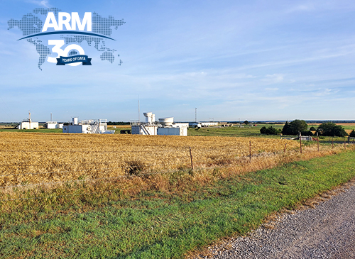
The Atmospheric Radiation Measurement (ARM) user facility’s flagship observatory is in a deliberately remote place.
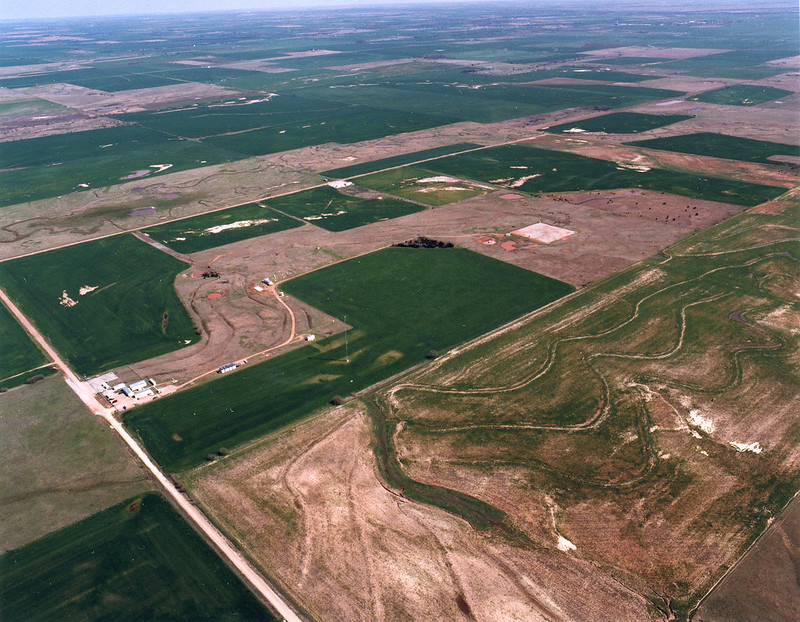
The Central Facility of the Southern Great Plains (SGP) atmospheric observatory is in between Lamont and Billings in north-central Oklahoma. Both towns, bracketed by cattle pasture and soybean fields, have fewer than 500 people.
ARM, a U.S. Department of Energy (DOE) Office of Science user facility, came into being just over 30 years ago to address concerns over the lack of data on atmospheric processes. Scientists need such measurements to inform and validate predictive models of climate and weather.
The remoteness of the SGP allows for reliable data on clouds, water vapor, and shortwave solar radiation. Remote means being free of the confounding atmospheric influences of big cities.
Getting to the SGP means finding your way among a spiderweb of gravel and dirt roads.
Get directions, says Dave Breedlove, a laser and radar systems technician who started at the SGP two months after it opened. “Four-wheel drive just gets you stuck farther from help. That’s really a distinct possibility out here.”
First Up, the SGP
The SGP is ARM’s oldest and largest observatory. In May 1992, the SGP recorded its first data.
At its spatial peak, the observatory stretched across 55,000 square miles in northern Oklahoma and southern Kansas. (The area of operations has since shrunk to 9,000 square miles for operational efficiency.)
Today, ARM has a coordinated network of six observatories—three in fixed locations and three that are mobile. (A fourth fixed observatory closed after operating for almost 20 years.)
Set in climate-critical regions of the world, ARM sites collect continuous data. In all, ARM has raked in, quality-checked, and archived more than 3 petabytes so far. Access to this trove is free online through ARM’s Data Discovery.
ARM users are still investigating questions DOE deemed urgent more than three decades ago. How can we get precise, continuous measurements of our atmosphere? How can we use these data to improve predictive models of climate change?
A Fast Start
The SGP provided the first examples of the way ARM operates―by combining in-depth, long-term data from continuous atmospheric measurements, regular field campaigns, and from shorter-term efforts called intensive operational periods (IOPs).
With a tight deadline to bring the SGP from drawing board to actuality, ARM’s creators leveraged years of managerial know-how within DOE.
“We assigned (DOE national laboratories) to lead each site,” says Gerry Stokes, ARM’s first chief scientist. “Largely, we wanted to take advantage of the fact that each lab had a well-established operational and environment, safety, and health culture for field programs. We did not want to develop our own―and really did not need to.”
From early on, Argonne National Laboratory in Illinois was responsible for the SGP.
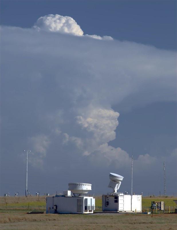
The SGP remains ARM’s main place for testing instruments and the source of most of the user facility’s data.
SGP Operations Manager John Schatz started with ARM in 1993 and now manages a staff of about 30. He was hired by the SGP’s first site operations manager, Jim Teske, who joined ARM from NOAA’s Wind-Profiler Demonstration Network, where he managed operations and instrument repairs.
Teske told Schatz: “Don’t take lightly what you are doing. The information we are collecting today will be studied by scientists around the world for decades to come.”
‘Field of Dreams’
Why care about a field of instruments in north-central Oklahoma?
To ARM planners, north-central Oklahoma seemed ideal. The topography was relatively flat, with simple features. It had four seasons and a wide range of atmospheric conditions. It had roads, so logistics could run smoothly.
“I saw the SGP site for what it could be―a world-premiere collection of instruments,” says the SGP’s first site manager, Doug Sisterson, a now-retired Argonne meteorologist.
ARM designed the remote location to be an outdoor laboratory dedicated to continuous measurements, reliable data for researchers and modelers, and instrument development.
For researchers, adds Sisterson, “SGP was our field of dreams.”
Build it, and scientists would come.
And they have. Since 1992, the SGP has hosted at least 300 field campaigns. Some have lasted years and some a few weeks.
Researchers have investigated patterns of solar radiative energy; cloud processes; severe convection; land-atmosphere interactions; atmospheric carbon levels; ice in clouds; and the size, distribution, and influence of atmospheric particles known as aerosols.
Researchers also come to the SGP’s field of dreams to test new instruments.
Early on, the SGP was called a Cloud and Radiation Testbed (CART).
The SGP was ARM’s first testbed for how to deploy and test instruments, transmit data, and structure management. Organizers used their experiences in Oklahoma and Kansas to refine how to pick and place instruments including radars, lidars, weather stations, and other assets.
It was a site for testing laboratory instruments hardened for the outdoors and designing networked arrays of low-tech, autonomous remote sensors.
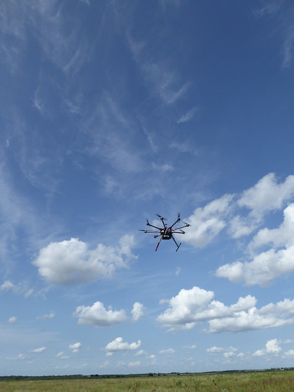
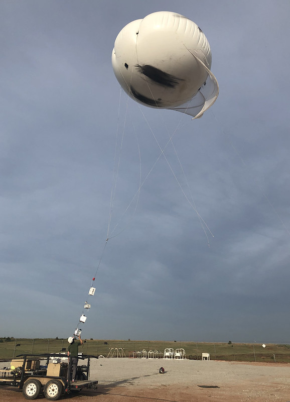
Scientists and engineers deployed small and large piloted research aircraft, experimented with instruments strung from tethered balloons, and miniaturized others to use in uncrewed aerial systems (UAS).
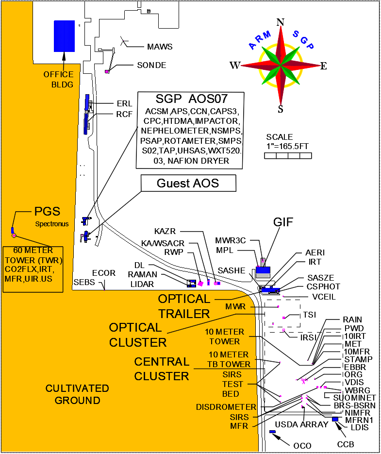
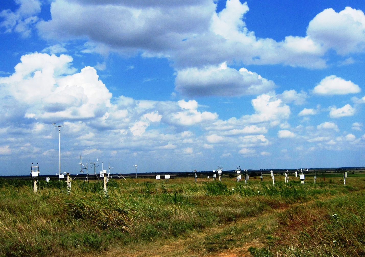
A Buildup of Instruments
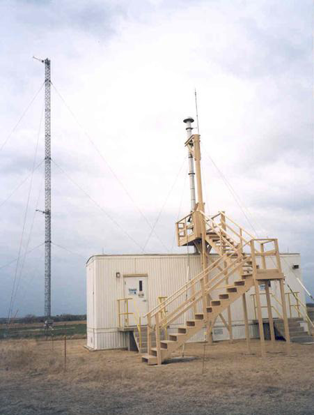
When operations started in 1992, the SGP had a trailer, a storm shelter, and seven gangly portable weather stations borrowed from the National Center for Atmospheric Research in Colorado.
By July 1993, the site had its own radar wind profiler with a radio acoustic sounding system. This system operated in a former shale pit to reduce the impact of its moans and squeals.
There were also improved instruments in place to capture data on surface meteorology and radiative fluxes, including a 60-meter (197-foot) instrument tower.
By December 1993, the SGP had an Aerosol Observing System, a whole-sky imager, a ceilometer to measure cloud height, and radiosonde systems.
The first small-scale IOP, on remote cloud sensing, took place in 1994.
IOPs made ARM’s fixed observatories “real user facilities,” says Stokes. “They could host other experiments, such as measurements by researchers who had their own instruments.”
In fall 1995, campaign ambitions and capabilities broadened with the ARM Enhanced Shortwave Experiment (ARESE), led by Francisco Valero, now an emeritus research scientist at the University of California, San Diego. ARESE deployed three aircraft and coordinated measurement activity with SGP ground instruments and satellites.
By 1996, the SGP had the first fully automated Raman lidar system. It could profile water vapor, clouds, and aerosols day and night thanks to automated algorithms. Its trial by fire took place that August and September in a boundary-layer experiment IOP.
The array foreshadowed an ARM future dominated by robust, automated observing and data-collection systems. It became part of a coordinated set of measurements that characterized clear-sky atmospheric conditions and that could be incorporated into regional-scale weather models.
Integrating IOPs
A 1997 field campaign at the SGP was the first to anticipate the scale of future efforts.
The three-week Integrated IOP campaign consisted of four IOPs that occurred simultaneously. The IOPs hit on all the ARM research hotspots of that era: water vapor, clouds, aerosols, and shortwave radiation.
There were two other experimental components, on UAS and the single-column model (SCM).
Pioneered in the 1980s, the SCM is a tool used by many climate modeling groups to evaluate the simulation of unresolved processes (clouds and radiation, for instance) within an atmospheric column. SCM simulations can be run very quickly with less computer power than full global climate models. They can also be more directly compared with observations.
The multi-IOP campaign, with three bases of operation and 75 scientists and engineers, deployed a UAS for high-altitude, long-duration observation flights. It used three fixed-wing research aircraft, 40 guest instruments, and 817 sonde launches. There were daily weather briefings and scientific meetings.
The University of Oklahoma’s Randy Peppler, manager of the ARM Data Quality Office, was onsite for the 1997 campaign. He was on a team run by Peter Lamb, the SGP’s first site scientist. (Lamb died in 2014.)
Peppler called University of Utah researcher Gerald “Jay” Mace the “scientific coordinator of this mega-IOP” and chief scientist for the component on clouds.
The 1997 combined-IOP field campaign “represents the era in which ARM pioneered the use of UAS,” says ARM Technical Director Jim Mather. “These campaigns were also tackling challenging issues associated with the interactions of radiation and clouds, including the details of spectral and geometric effects.”
The campaign also foreshadowed the energy DOE and ARM would increasingly pour into aerial research platforms. The results proved how useful such platforms could be in profiling the atmosphere and capturing radiative fluxes.
ARM used aircraft at the SGP starting in November 1993 with its first engineering UAS test flights.
Data in Tandem
In 2000, the SGP hosted the ARESE II IOP, led by Robert “Bob” Ellingson, an early ARM planner.
ARESE II deployed a piloted Citation aircraft instead of UAS, which were still largely used for testing.
The year 2000 stood out for other reasons too, says Mather.
That was when the Spring Cloud IOP took place. This SGP field exercise, led by Mace, was “emblematic for a decade of campaigns,” says Mather. “It involved extra radiosonde launches, a multifaceted data set, and it pointed to the efficacy of IOPs.”
Much of the reason the Spring Cloud IOP was so important was that many other activities went on at the same time. During that spring, there was ARESE II, along with a single-column model IOP and tests of several instruments.
“Jay (Mace) didn’t lead all those pieces,” says Mather. “But they all contributed to a remarkable data set.”
Also in 2000, the seven-year In-Situ Aerosol Profiles (IAP) campaign began.
IAP was led by John A. Ogren, then at the NOAA Earth System Research Laboratory in Colorado. The campaign employed a small Cessna aircraft as the main instrument platform. It was the first long-duration, aircraft-based observation of its type.
IAP and the 1997 combined-IOP campaign also signaled an era when SGP work started to focus more strongly than ever on aerosols.
Before long, IAP was regarded as “an important part of ARM instrumentation and capabilities, and in line with the ARM mission,” says IAP team member Sébastien Biraud of Lawrence Berkeley National Laboratory in California.
Starting in 2008, Biraud led what became a long series of ARM Airborne Carbon Measurements (ARM-ACME) campaigns. These air-surface-satellite investigations focused on carbon dioxide and methane, both prominent atmospheric trace gases.
The ARM-ACME series ran for 53 months over an eight-year period, wrapping up in 2016. In four separate ARM-ACME campaigns, researchers studied trace gas transport on continental scales, land-atmosphere carbon exchanges, and gas interactions with water and energy fluxes.
In a break from the skies over the SGP, one ACME campaign—the 3.5-month ARM-ACME V—took place over ARM’s North Slope of Alaska atmospheric observatory.
Deep Into Deep Convection
Around the time Biraud started ARM-ACME, the SGP was changing character.
In 2009, ARM shrank the observatory’s size. By then, models using ARM data had improved resolution. That meant coverage of a smaller area was needed to represent a model grid cell.
Less than two years later, ARM received an infusion of money to upgrade instruments across its sites. The SGP acquired new capabilities, including scanning cloud and precipitation radars and Doppler lidars.
In 2011, the SGP was ready for what became one of its signature campaigns.
Michael Jensen of Brookhaven National Laboratory in New York led an elaborate, six-week multi-agency IOP called the Midlatitude Continental Convective Clouds Experiment (MC3E).
In this ground-aircraft-satellite effort, ARM collaborated with a program within NASA’s Global Precipitation Measurement mission.
Researchers dug into the life cycles and processes of convective clouds, including the pre-convection environment and how convective clouds formed.
The idea was to document, in three dimensions, the activity of clouds, winds, and moisture in unprecedented detail―all to improve models by providing simplified representations of complex processes. MC3E established a dialogue with modeling groups within DOE’s Atmospheric System Research (ASR) program.
At hand were the SGP’s newly augmented extensive remote-sensing instruments. NASA contributed, among other measurement assets, scanning radars, high-altitude remote-sensing gear, and instrumented aircraft.
MC3E deepened the character of collaboration that ARM’s founders leveraged. From Day One, the MC3E team reached out to researchers from national laboratories, universities, industry, and other federal agencies with climate science missions.
Jensen called MC3E “one of the most successful campaigns ARM has ever done.”
In ARM’s publications database, which tracks papers using ARM data, MC3E has 94 journal articles—the most of any SGP campaign—as of June 2022.
Tying Sky to Land
Most science to come out of the SGP relates to radiation, clouds, and aerosols. Increasingly, scientists are paying more attention to a research pathway that ties the sum of climate factors together: land-atmosphere interactions.
In that regard, the 2016 Holistic Interactions of Shallow Clouds, Aerosols, and Land-Ecosystems (HI-SCALE) campaign stands out.
Jerome Fast, an atmospheric scientist and modeler at Pacific Northwest National Laboratory (PNNL) in Washington state, led this research effort. HI-SCALE used ARM’s Gulfstream-159 (G-1) research aircraft and ground-based instruments.
The campaign focused on shallow clouds―how they form and the processes that affect them. Short-lived and dispersed, they are hard to represent in models. Yet shallow cumulus clouds move heat and moisture into the atmosphere from the Earth’s surface, setting the stage for the formation of larger clouds.
Such clouds were also the subject of a first-of-its-kind campaign at the SGP in 2009. It collected airborne data over an extended period—more than five months—to improve the statistical characterization of continental boundary-layer clouds.
Data from the Routine ARM Aerial Facility (AAF) Clouds with Low Optical Water Depths (CLOWD) Optical Radiative Observations (RACORO) campaign informed an understanding of how cloud processes work at a microphysical level.
RACORO data also paved the way for observationally based case studies and large-eddy simulations (LES).
LES are mathematical models of the turbulence and fluid dynamics that characterize air circulation in the atmosphere.
Years of data on cumulus clouds over the SGP also informed the first iteration of the LES ARM Symbiotic Simulation and Observation (LASSO) activity. LASSO produces high-resolution simulations based on ARM measurements.
Through LASSO, researchers can access simulations to improve how weather and climate models represent cumulus clouds. Five seasons of LASSO SGP case studies are available from 2015 to 2019. (LASSO has now shifted to a focus on deep convection observed during a campaign in Argentina.)
Going Small
In addition to hosting large-scale campaigns, the SGP welcomes what are called small campaigns, which may include deployment of guest instruments at ARM observatories, collection of aerosol or precipitation samples, or special operations of ARM instrumentation, such as enhanced radiosonde launches or special scanning strategies.
So far in 2022, the SGP has been busy with small campaigns.
In February and April, the SGP hosted a combined six weeks of tethered balloon system operations led by Dari Dexheimer of Sandia National Laboratories in New Mexico. She and her team are scheduled to come back for two weeks in the fall.
In April, PNNL scientist Susannah Burrows continued her long work at the SGP with a campaign to gather supplemental samples of warm-temperature ice-nucleating particles linked to agricultural soils.
From April to May, Eleanor Browne, an assistant professor at the University of Colorado, Boulder, wrapped up a campaign to characterize new particle formation and growth.
Through the summer, Suzanne Paulson of the University of California, Los Angeles, will continue a campaign to expand her work on the chemistry of cloud water and how clouds process aerosols in urban settings.
Regarding ARM’s history, says Mather, “We tend to think about large campaigns. But small campaigns are conducted at the SGP every year―and the large majority of ARM campaigns are small.”
This, he adds, is a reminder of the SGP’s own small beginnings. “It takes us full circle.”
Follow Us:


Keep up with the Atmospheric Observer
Updates on ARM news, events, and opportunities delivered to your inbox
ARM User Profile
ARM welcomes users from all institutions and nations. A free ARM user account is needed to access ARM data.


