

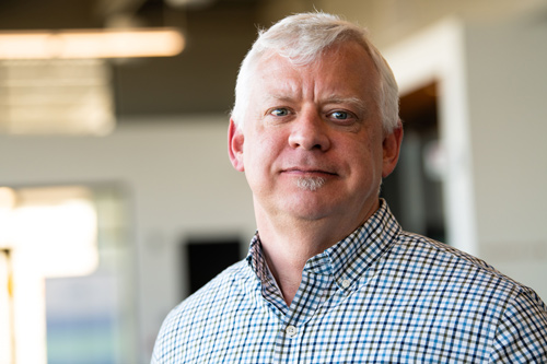
Jerome Fast: Modeler of the Land-Atmosphere Interface
Published: 17 August 2020
A senior investigator studies the coupling of the Earth’s surface with the lowest layer of the atmosphere, where storms and precipitation are made
One summer day in 1983, Jerome Fast stepped outside his boyhood home in Mountain Lake, Minnesota (population 2,000). Whirling on the horizon was his first tornado.
“Dad forced me to come inside,” he says, “and I haven’t seen a tornado since.”
Still, even one brief look at a looming twister was enough to set the hook for Fast, who was about to enter his second year as a meteorology student at nearby Iowa State University (B.S. 1985, M.S. 1987, PhD 1990).
“I decided that was something I wanted to do,” he says―a practical way to exercise his lifelong interest in science.
Today, Fast is a highly published atmospheric scientist at Pacific Northwest National Laboratory (PNNL) in southeastern Washington state. At PNNL, his research interests include modeling aerosols, clouds, aerosol-cloud interactions, and the dynamic interface of the land surface and the atmosphere.
He joined PNNL in 1994 after four years at the Savannah River Technology Center in Georgia, where he simulated the dispersion of chemical plumes in the atmosphere.
“I do a lot of modeling now,” says Fast, whose research brings him in touch with the U.S. Department of Energy’s (DOE) Atmospheric Radiation Measurement (ARM) user facility and Atmospheric System Research (ASR).
His early knack with numbers has proven useful over the years. (Fast was a double major in meteorology and mathematics before doing graduate work.)
“To represent the atmosphere, you need equations,” he says. “Mathematics is a key tool you need for science.”
The First Model
It was at Iowa State “where my first interest and experience in modeling began,” says Fast, a laboratory fellow at PNNL.
One of his professors owned a one-processor Linux computer―quite the rarity back then, but which today has far less computing power than a cell phone.
“I got to play on it,” says Fast, and started to develop a model. “But first I had to think of a science application for it.”
That turned out to be low-level jets, which are wind-speed maxima that typically occur close to the ground―within a few hundred meters or even a kilometer of the surface. They form over the Great Plains after dark, bringing atmospheric instability in their wake and prompting the nighttime thunderstorms every Midwesterner knows.
The model turned out to be the subject of Fast’s PhD dissertation. It also introduced him to the enduring puzzle of land-atmosphere interactions, a theme underpinning much of his research since then.
While writing the dissertation, he says, “I looked at the sensitivity of the atmosphere to soil moisture, which evaporates and cools the ground and changes the near-surface temperature.”
On that same subject, he was first author on a 2019 paper in the Journal of Advances in Modeling Earth Systems. “It’s amazing how I have gone full circle,” he says.
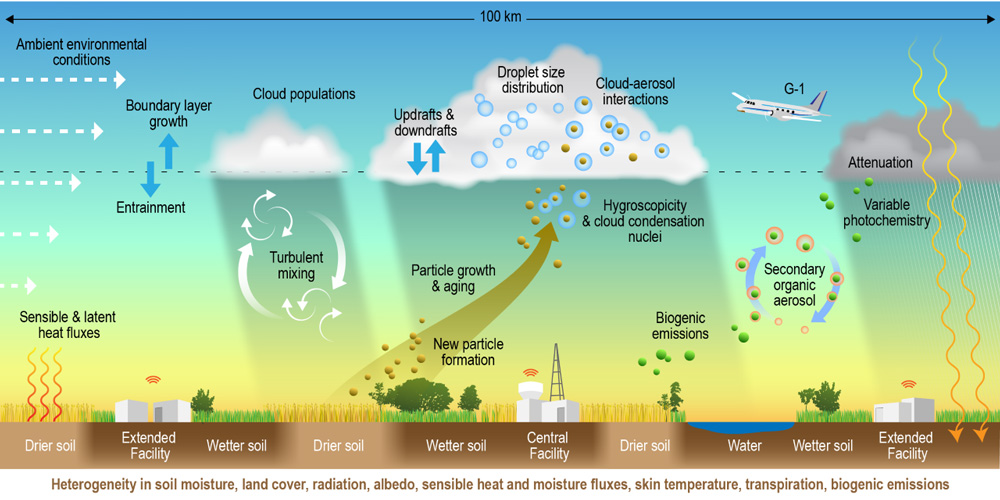
He and his co-authors developed a high-resolution model initialized by realistic soil-moisture variations, which they found could reproduce the distribution of clouds in a way that nearly matched observations. They also tracked thousands of individual shallow cumulus clouds. Results showed that simulating realistic soil moisture conditions produced close-to-reality clouds that were larger and had longer lifetimes than those produced in models that used more uniform soil-moisture variations.
The paper’s model is based on a large-eddy simulation with grid spacing of 100 meters (328 feet). It makes the argument, says Fast, that current mesoscale (regional) models need to account better for variable land-atmosphere interactions.
Mimicking Reality
Models are a form of construction. They bring with them the same satisfaction as assembling a building or bridge, says Fast. “You’re building something, but it’s on a computer. And it enables all sorts of scenarios. The fact that (a model) mimics reality is fascinating―that you can write some code and its output looks like something you observe.”
Model results are surprising sometimes, he says. “But that’s because the atmosphere is based on mathematics―and a little bit of chaos.”
Still, any atmospheric model begins with observations, which suggest the scientific problem.
“The model is the approach to better understand what is being observed,” says Fast. “That’s been my whole career: grounding the model with observations, the measurement-to-modeling bridge.”
Going on field campaigns was an important part of that bridge, to a degree that is unusual today for most modelers. Many remain computer-bound either by inclination or because the costs of 21st-century campaigns limit the ability of modelers to gain other skills.
Fast went to Mexico for his first field work in 1997 as part of IMADA-AVER, a boundary-layer experiment in the Mexico City area.
Inspired by the perspective that field work offers a modeler, he says, “as other opportunities came along, I pursued different aspects of field work.”
What followed were campaigns in Arizona, Utah, and Mexico City again―in 2006 this time―for the Megacity Initiative: Local and Global Research Observations (MILAGRO) project, which included DOE resources.
HI-SCALE Heights
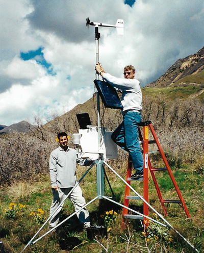
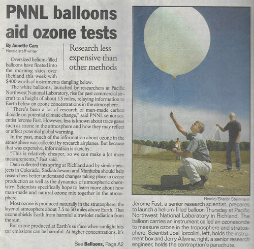
There were other field campaigns Fast accompanied, in Sacramento, California; on Cape Cod, Massachusetts; and in the vicinity of PNNL―a small atmospheric chemistry experiment to launch ozonesondes into the troposphere and stratosphere called TOPSE.
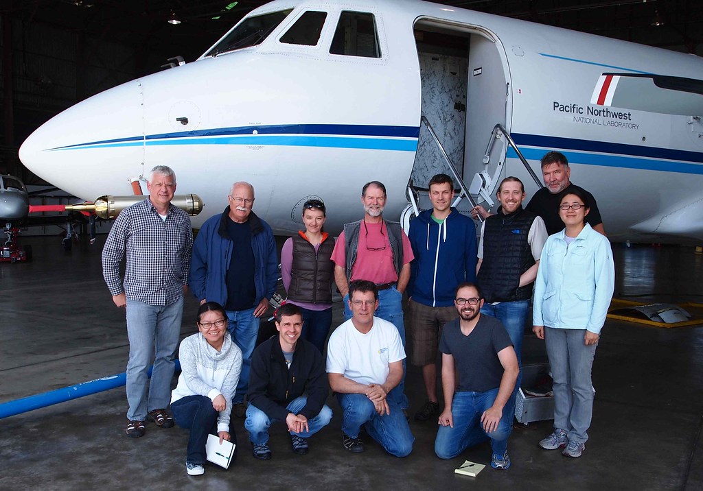
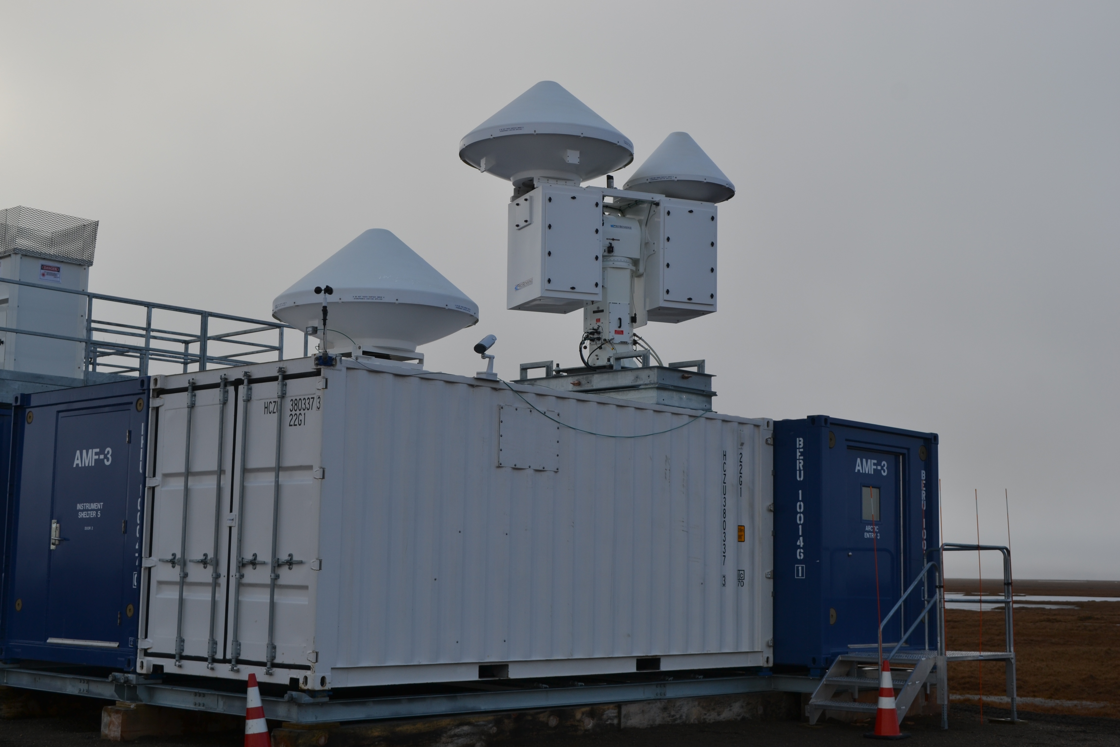
But he is best known for a field campaign he organized: Holistic Interactions of Shallow Clouds, Aerosols, and Land-Ecosystems (HI-SCALE) in 2016. The campaign combined aerial and surface measurements at and above ARM’s Southern Great Plains (SGP) atmospheric observatory, which spans parts of stormy Oklahoma and Kansas.
HI-SCALE is an attempt to “better understand the processes that affect shallow clouds and why they form as they do,” says Fast.
Current operational and climate models cannot explicitly represent shallow clouds. They typically predict that conditions will be sunnier and warmer than observations suggest.
“That’s the bias of models: It gets too warm near the ground,” he says, in part because models do not adequately capture the cover provided by very small clouds.
Fast was lead author on a 2019 paper describing HI-SCALE in the Bulletin of the American Meteorological Society (BAMS). It outlined progress since the original mission, which was to investigate the effect of land-atmosphere interactions and aerosols on shallow convection, as well as the distribution and number of clouds.
The Ongoing and the Intriguing
“There are a lot of ongoing efforts. It usually takes several years after a campaign to fully examine the data.”
Fast, on his HI-SCALE field campaign
“There are a lot of ongoing efforts,” says Fast of HI-SCALE. “It usually takes several years after a campaign to fully examine the data.”
He and co-authors submitted three papers that follow up on the 2019 study.
Fast noted an intriguing HI-SCALE-related paper that appeared in January 2020 in Science Advances: a study led by Michael Lawler of the University of California, Irvine, on episodic bursts of nanoscale fungal particles into the atmosphere over cropland in northern Oklahoma. These bursts represent numbers “magnitudes higher” than other biogenic particles in the region, says Fast, and are similar to bursts found in the Amazon.
They also represent, he adds, “a large (repository) of both cloud-forming ice nuclei and respirable allergens.”
Fast shared glimpses of some intriguing but not-yet-published findings related to HI-SCALE. For one, researchers made first-time concentration measurements of isoprene products within and surrounding clouds. Isoprene, a plant-based volatile organic compound, is the largest global contributor to the formation of secondary organic aerosols. Southeast of the SGP, it is emitted by oak forest cover.
Another glimpse of forthcoming research: HI-SCALE aircraft measurements observed new-particle formation events on the surface that occurred simultaneously aloft―a rare measurement two-fer in atmospheric science.
Promising Data Sources
Think of Fast and you might also think of an ambitious Scientific Focus Area project he has overseen for the past nine years: the Integrated Cloud, Land-Surface, and Aerosol System Study (ICLASS), funded through 2020 by ASR.
He earlier called these complex interactions “one of the most important challenges in atmospheric science.”
HI-SCALE, the project’s leading experimental edge, derived much of its punch from aerial measurements by ARM’s now-retired Gulfstream-159 (G-1) aircraft. (Fast designed the scheme for airborne data collection.)
In the future, investigations of the boundary layer and of land-atmosphere interactions will benefit greatly from supplemental forms of airborne measurement, says Fast, including tethered balloon systems (TBS) and unmanned aerial systems (UAS).
“These things are going to be used far more often,” he says.
TBS—more mature than UAS and deployed extensively during small campaigns at the SGP in 2019—offer much longer sampling times than two to four hours of data from an aircraft. But they are hampered by weight restrictions, says Fast, “so there are many types of measurements they can’t make.”
The same weight restrictions apply to UAS, even more severely, he says, but they fly low and slow for long periods of time―a boon to studies of boundary-layer processes and the influence of landforms on the atmosphere.
Fast has a proposal in the pipeline at the Environmental Molecular Sciences Laboratory (EMSL), a DOE user facility at PNNL. He wants to analyze some EMSL data collected on the TBS at the SGP during the spring and summer of 2019.
“But even if it isn’t funded,” he says, “I need to figure out a way to use some of that (TBS) data.”
Future Directions
Beyond writing the EMSL proposal, Fast has his name on a number of proposals involving the ARM Mobile Facilities. His team is also considering how the mobile observatory to be deployed in the U.S. Southeast can be used to answer science questions of interest to ICLASS.
“It’s very synergistic with the things we do at SGP,” he says.
Both observatories will be in regions swept by heavy convective storms, he says, “but both (have) very different land use. It will be great to (compare) local land-use characteristics.”
Five years out, Fast imagines a few scenarios for himself. One is to continue research along the same lines, though with different scientific problems.
But he says he is also “inching my way in two different directions.”
One is to go to very small scales using large-eddy simulations―down to three-dimensional study grids of “tens of meters or hundreds of meters,” says Fast, “especially to look at fast-reaction chemistry within these eddies.”
At the same time, “I can see myself ramping up to the scale of global modeling,” breaking away from the mesoscale realms he has dealt with to date, he adds. “That’s the sweet spot where I have been.”
This scaling-up inclination, so far, is embodied in a small role Fast has with DOE’s Energy Exascale Earth System Model (E3SM) development project.
“I’m interested in how aerosols and chemistry are represented in those models,” he says.
Into the Wilderness
With those two directions in mind, as possibilities, “I am almost bifurcating,” says Fast.
He did that, in a way, much earlier―and benefited.
During his youth in Mountain Lake, Minnesota, where his parents ran the local Dairy Queen restaurant, Fast named the art teacher as his biggest influence in high school. He started painting oils back then, and still does.
Moreover, Fast has brought his artistic inclinations to science.
“I like to think I have a creative side, as well as a scientific, analytical side,” he says. “I bring (my art) into work a lot by bringing it into graphics.”
Done well, says Fast, science art “tells the story of what you are doing.”
Occasionally, though, he trades intellectual endeavors for day-hiking in the woods of the Cascade mountains west of PNNL or in the Rockies after business trips to Boulder, Colorado.
“The main thing is to just to get out into the wilderness,” says Fast, “and get away from all this technology.”
Follow Us:


Keep up with the Atmospheric Observer
Updates on ARM news, events, and opportunities delivered to your inbox
ARM User Profile
ARM welcomes users from all institutions and nations. A free ARM user account is needed to access ARM data.


