
Evolve and Innovate: ARM Looks Ahead
Published: 26 July 2023
Insiders foresee more open science, artificial intelligence, urban studies, satellite collaborations, and sharpened instrumentation
Most scientists agree: Time travel is not possible.
But what about science stories? They can take you into the past.
For instance, the Atmospheric Radiation Measurement (ARM) user facility recently published a series of features looking back at its first 30 years of data.
ARM, a U.S. Department of Energy (DOE) Office of Science user facility, collects observations worldwide on what makes weather and climate tick. Modelers use these data to test and inform their simulations.
And what about time-travel glimpses into the near future? There is the recent series on ARM’s 2021 Decadal Vision document: look-ahead features on field measurements, data analytics, data services, and amplifying the impact of ARM observations on models.
In recent conversations, ARM Director Jim Mather and others sketched in a few extra details on plans and aspirations for the coming decade. Many of these plans will come up in breakout sessions during the August 2023 Joint ARM User Facility/Atmospheric System Research (ASR) Principal Investigators Meeting in Rockville, Maryland.
Included, of course, is the expansion of capabilities to collect and manage data.
“This is only natural,” says Adam Theisen, ARM’s instrument operations manager, who foresees streamlined and automated tools and processes. “As the science keeps evolving, ARM is going to have to evolve too and innovate to provide valuable new data sets.”
A Sense of Urgency
Those new data sets will have critical meaning.
“We’ve looked back over the last 30 years and our support for the advancement of a lot of science issues,” says Mather. “As a consequence, scientists are tackling increasingly detailed and complex problems.”
He offers two examples.
One is the hard-to-study complexity of land-atmosphere interactions, which start with bedrock, reach through complex soil and vegetation, and then into the atmosphere.
The other example presents an equally stupefying level of complexity: the ever-shifting, three-dimensional (3D) interactions of aerosols and clouds.
Aerosols are the tiny, fast-mutating particles of gases, water, and solids in the atmosphere that make clouds and precipitation possible.
Good observations are the key to unlocking at least some of these complexities.
“When we started this 30 years ago, climate change was a theory. There wasn’t a lot of observational evidence,” says Mather, whose own involvement with ARM started in the 1990s. “But now, things are for real―and accelerating. There is a sense of urgency.”
To meet that sense of urgency, he adds, “We are making significant changes to increase ARM’s impact on the pressing science issues.”
‘The Most Complex Deployment’
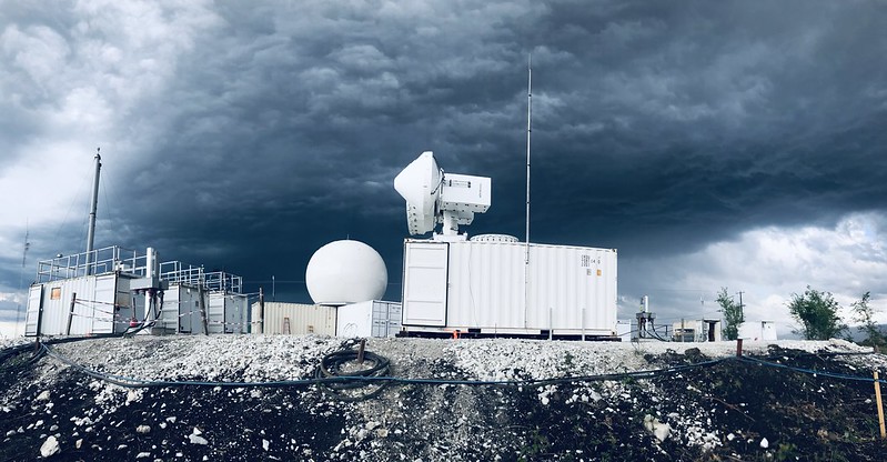
One of those changes is an upcoming addition by ARM: the Bankhead National Forest (BNF) long-term mobile observatory in northwestern Alabama, which Mather says is “the most complex deployment we’ve taken on since SGP (Southern Great Plains).”
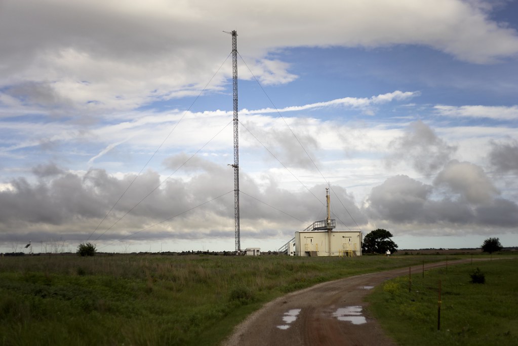
The 31-year-old SGP, located across 9,000 square miles of Oklahoma and Kansas, is ARM’s oldest and largest atmospheric observatory.
The BNF, operational later in 2023, will be rigged with 50-plus instruments and a planned 140-foot observation tower. Its study area represents what Mather calls “a very heterogenous environment,” with a torrent of mixed atmospheric influences from forests, meadows, farms, and distant cities.
“BNF will explicitly bring together different segments of the (research) community to go after the aerosol-cloud and land-atmosphere interaction problems,” says Mather.
Surface instruments at the BNF will soon be augmented by sampling from aircraft, tethered balloon systems, guest instruments aboard mobile vans, and additional “opportunities to partner with other ground-based networks,” says Mather, who sees the BNF as an example of ARM’s intensifying collaborative nature.
Nicki Hickmon, ARM’s associate director for operations, agrees that the BNF is a good example of “domestic data-sharing and collaboration,” including the use of guest instruments and partnerships with existing local observation networks.
Cities at the Forefront

As a recent example of ARM’s intensifying collaboration, Mather used the 2021–2022 TRacking Aerosol Convection interactions ExpeRiment (TRACER) in the urban-rural-coastal region around Houston, Texas.
TRACER, a grand coordinated effort to measure what influences convective systems, involved 150 participants from 45 institutions at more than 10 fixed and mobile observation sites.
Cities like Houston are at the forefront of human impacts on the atmosphere, in what Mather calls “a human-influenced world.”
Starting in fall 2024, ARM is slated to conduct a mobile facility deployment in an urban region as part of DOE’s Urban Integrated Field Laboratory (UIFL) effort. UIFLs will marshal resources across the Earth and Environmental Systems Sciences Division within the DOE Office of Science’s Biological and Environmental Research program.
The idea is to join with regional collaborators, including local universities, to comprehensively study urban environments and their interactions with the climate system. Included will be field measurements, data analysis, high-resolution modeling, and data-model fusion.
Such knowledge, DOE says, will “inform equitable climate and energy solutions that can strengthen community-scale resilience across urban landscapes.”
The UIFLs are focusing on Baltimore, Maryland; Chicago, Illinois; the Beaumont-Port Arthur region along the Texas Gulf Coast; and the Tucson-Phoenix-Flagstaff corridor in Arizona.
ARM and New Eyes in the Sky
Reaching into the world of international observations, Mather reached for the sky: planned satellite partnerships.
Between ARM and partners in Europe, “there is a lot of interest on both sides for mutual benefit and mutual support,” he says.
EarthCare, a cloud-observation satellite mission managed by the European Space Agency, is set to launch in 2024.
Such a satellite program, says Mather, “can provide a lot of information on this (land-atmosphere) heterogeneity question.”
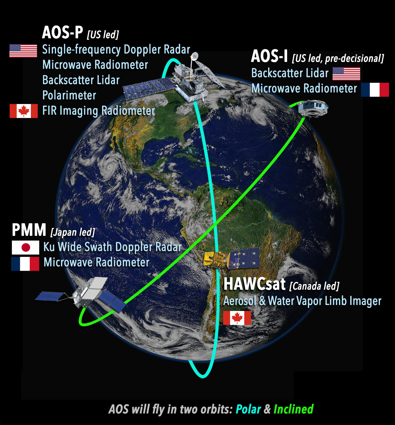
Domestically, NASA’s Atmosphere Observing System (AOS) launch of two satellites is slated for 2028 and 2031. The AOS devices, in collaboration with two satellites from international partners, will fly in polar and inclined orbits.
The AOS mission is to observe and clarify the same aerosol and cloud processes that ARM observes from the ground. Such processes contribute to climate change and extreme weather.
Collaborations in Europe, especially, are already informing talks between ARM and its international partners on the issue of data-sharing and compatibility.
Mather says that he and ARM Associate Director for Research Jennifer Comstock “have been engaged with a number of organizations, part of close to a dozen different activities on the theme of data compatibility and data interoperability,” both in Europe and the United States.
One ARM-like entity in Europe is the Aerosol, Clouds and Trace Gases Research Infrastructure (ACTRIS).
“Some ACTRIS sites are similar to ARM sites,” says Mather, “and others have quite different characteristics,” which is also true of NASA and other observation infrastructure worldwide. “If we can provide datastreams that are similar, that will make the consumption of those data much easier. We really want to strive toward this.”
Data Dreams
ARM has an eye-popping trove of atmospheric data accessible in Data Discovery―more than 4 petabytes, a figure that is estimated to reach 5.5 petabytes by the end of 2023.
Data will rack up even more if “the linked global network combining ARM with other observatories” that Mather imagines comes true.
But let’s say that takes a while longer. Meanwhile, for ARM alone, the amount and complexity of the data rolling in will present challenges in the coming decade.
ARM Data Services Manager Giri Prakash breaks down the next-generation challenges in three ways:
- Data fusion and feature extraction. Driven by artificial intelligence (AI), ARM will “integrate and extract data from various sources,” says Prakash. AI-aided “fusion” of ground, airborne, and satellite data will lead to a more comprehensive view of the atmosphere.
- AI-powered decision support. That means integrating AI and machine learning for “decision support systems,” says Prakash. Such systems can help interpret data, generate insights, and facilitate evidence-based decision-making. But there are challenges, he adds: creating user-friendly interfaces, making AI models easy to interpret, and disseminating complex findings to diverse user groups.
- Big data management. Imagine massive data from diverse sensors and instruments. Then imagine trying to manage, store, process, and analyze all of them. “The next generation,” says Prakash, will involve “innovative strategies and infrastructure to handle ever-growing data sets.”
AI, Supercomputing, Open Science
“Artificial intelligence is clearly ramping up like nobody’s business,” says Mather. “Improving our assessment of data quality is at an inflection point now.”
Theisen agrees, adding that “generative AI tools could have a lot of impact in making ARM data more accessible and searchable.”
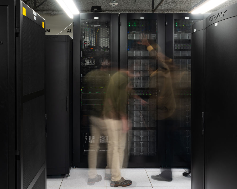
Linked to the idea of AI is another data-related theme, says Mather: “Our computational capabilities are becoming much more sophisticated. We have the tools now to deal with these large, complex data sets.”
Those tools include the new Cumulus high-performance computing cluster, available since early 2022. The new Cumulus, stacked with more than 16,000 processing cores, is already speeding up some of ARM’s computationally intensive activities, including data quality analysis and radar data processing.
In the same vein, Hickmon sees an ARM future with more “open-source code-sharing, workforce development, and user support through tools, tutorials, webinars, edge computing, dynamic observations, and data-sharing.”
Instruments: New, Emerging, Evolving
Atmospheric observations come from instruments operated at the surface, strung up on balloons, racked into aircraft, or installed on satellites.
In its own toolbox, ARM has more than 460 instruments cataloged among its surface and aerial observation assets.
Beyond those, says Mather, “We’ll continue to explore sampling strategies with new and emerging instruments.”
During TRACER, ARM and the National Science Foundation funded new storm-tracking techniques deployed by Brookhaven National Laboratory.
Overseen by Pavlos Kollias, a combination of aircraft, surface observatories, and radar (including a second-generation C-Band Scanning ARM Precipitation Radar) delivered what he calls the largest-ever database of isolated convective cells to be individually tracked. Many were tracked in near-real time thanks to a new algorithm.
Meanwhile, says Mather, aerial capabilities will remain important to provide spatial context and collect measurements that are out of reach for surface instruments.
ARM will receive its new high-altitude, long-range research aircraft in about 18 months, he says, with testing and instrument integration following that.
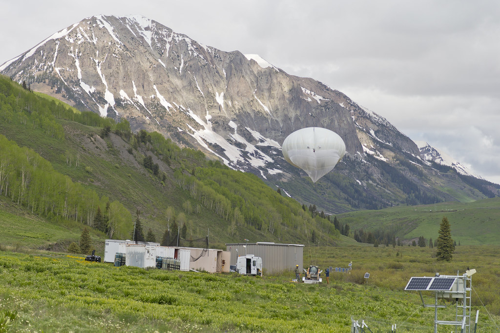
Tethered balloon systems will be increasingly deployed to get fine-grained measurements of the atmosphere’s vertical structure.
And more and more, the steady, horizontal flight paths of uncrewed aerial systems will provide what Mather calls “a very dense (picture of) three-dimensional structure” around ARM sites.
‘A Lot of Excitement’
“Expect to see more adaptive operations going forward to optimally sample the environment,” says Mather of ARM’s near future. “That’s always a drive: to provide the most impactful measurements.”
Of all the insiders looking ahead, Theisen had the most dramatically futuristic take.
“There’s a lot of excitement about ARM deploying the latest and greatest technologies or funding development efforts,” he says―but there could be more.
“It may be possible that ARM is fielding its first quantum-based instruments 10 years from now,” imagines Theisen, as if fresh from a time-machine ride into the future. “Or that our mobile facilities are run entirely off renewable energy for even more remote deployments.”
Follow Us:


Keep up with the Atmospheric Observer
Updates on ARM news, events, and opportunities delivered to your inbox
ARM User Profile
ARM welcomes users from all institutions and nations. A free ARM user account is needed to access ARM data.


