

ARM’s Decadal Vision, Part 1: Field Measurements
Published: 24 August 2021
ARM plans for years of comprehensive and impactful data from field instruments
Editor’s note: This is the first article in a series about the four themes in ARM’s Decadal Vision document.

All life on Earth lives within a shell of atmosphere that has an average thickness of just 7 miles (11 kilometers). All clouds exist inside this same thin layer. All weather takes place there too.
This atmosphere is made of gases, water vapor, and aerosols―the ultrafine liquid and water particles that seed clouds and scatter or absorb sunlight. The physics of the atmosphere drives the dynamic transfer of heat, moisture, and momentum to and from the Earth’s surface.
How do these atmospheric processes work? How do scientists observe them? How can modelers use observations to predict future states of the atmosphere and climate?
These questions require the kind of atmospheric data that for almost 30 years have been collected, processed, and delivered to researchers by the Atmospheric Radiation Measurement (ARM) user facility, funded by the U.S. Department of Energy (DOE).
Aspirational Themes
ARM’s measurements come from fixed, mobile, and aerial atmospheric observatories and assets. An ARM community of affiliated scientists and data users recognizes that field measurements need to be continually updated and improved.
Improving measurement strategies and equipment is one of four aspirational themes outlined in ARM’s 31-page Decadal Vision document, published in May 2021 and written by ARM Technical Director Jim Mather.
The other themes, to be described in future ARM feature articles, relate to improving data analytics, enhancing data services, and amplifying ARM data in earth system models.
“It’s all become so complex,” says Mather of the need for a decadal report. “We have to take a step back.”
The key points to the measurements section of the report begin with “operating the instruments that will have the greatest science impact,” he says. “We’ll do this through community engagement, reviewing current and potential measurements, and continuing to pursue several large development projects that are expected to advance and broaden our ability to support the science community.”
Those large projects include expanding airborne research capabilities and establishing a new observatory in the Southeastern United States.
A second key point, adds Mather, is to “increase the impact of our measurements by exploring non-traditional operating modes.”
Measurements are first on the Decadal Vision list in part because of the volume of ARM data already archived: over 3 petabytes, an amount expected to double in just a few years. Meanwhile, ARM data are flowing every day into 2,500 active, continuous datastreams from more than 450 instruments around the world.
“How do we move ahead with all that information?” asks Mather, noting not only more data but increasingly complex challenges in atmospheric science. “It’s mind-boggling.”
For ARM, he says, one answer was to update the user facility’s 2014 Decadal Vision.
A New Observatory
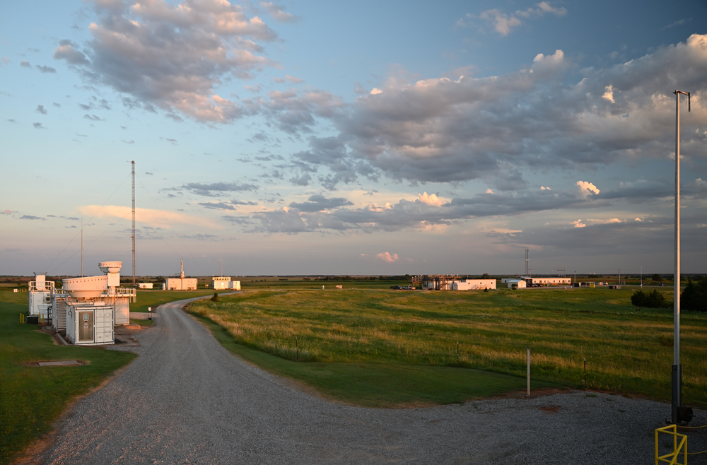
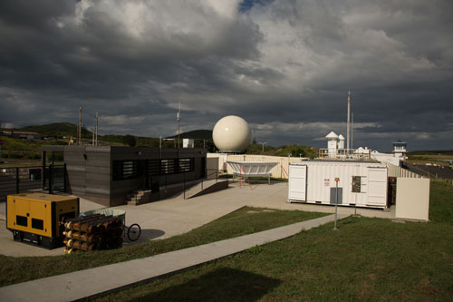
ARM operates three fixed-location atmospheric observatories. They are in far-north Alaska (where rapid changes in the Arctic are evident), the U.S. Great Plains (where consequential storms are frequent), and in the eastern North Atlantic (where vast decks of marine stratocumulus clouds influence the Earth’s energy budget).
Its three ARM Mobile Facilities (AMF) operate elsewhere around the world, collecting data for up to a year (in most cases), based on user proposals. (A new call for AMF proposals will go out in late fall 2021.)
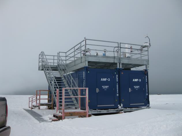
In the summer of 2021, an extended deployment of the third ARM Mobile Facility (AMF3) ended after almost eight years at Oliktok Point, Alaska. Those pods of mobile instruments will next go to the Southeastern United States.
Beginning in 2023, AMF3 will operate in that region for five years or more. The exact location, likely in Alabama, will be announced in late 2021. A site science team supported by ARM and DOE’s Atmospheric System Research (ASR) is developing a science plan and initial research project for the deployment.
A Southeastern U.S. AMF deployment offers opportunities to focus on boundary-layer dynamics and land-atmosphere dynamics in a region where convective storms initiate over heterogeneous terrain influenced by farm, forest, and urban areas. The region, where secondary organic aerosols are significant, will also open opportunities for studying aerosols and aerosol processes.
“Deploying the AMF3 (in the Southeastern United States) provides unique opportunities for ARM,” says Chongai Kuang, the AMF3 site science team lead from Brookhaven National Laboratory in New York.
Those opportunities include partnering with local universities, agencies, and measurement networks, which Kuang says will “grow not only the observational footprint of the AMF3, but also the scientific and educational impacts of the AMF3 deployment.”
Advanced Aerial Measurements
Aerial platforms, another feature of the Decadal Vision report, add to the quantity, diversity, and quality of ARM data. They collect observations on the chemistry of aerosols and the microphysics of cloud droplets. They provide spatial context and validation for ground-based measurements.
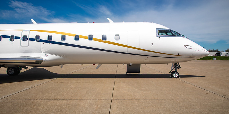
Enhancements to the ARM Aerial Facility (AAF) have been underway for some time. They include a newly acquired Bombardier Challenger 850 regional jet, which is being modified to replace ARM’s retired Gulfstream-159 (G-1) for science flights.
The Challenger 850 exceeds the G-1 in altitude, payload, and endurance―and it is likely to include new instrument capabilities.
“The entire AAF is super enthusiastic about being able to provide such a capable airborne laboratory to the research community in the near future,” says AAF Manager Beat Schmid.
ARM is also focused on two other aerial enhancements.
Uncrewed aerial systems (UAS) have larger and heavier platforms now under development. Tethered balloon systems (TBS) have been maturing since their ARM introduction in 2015.
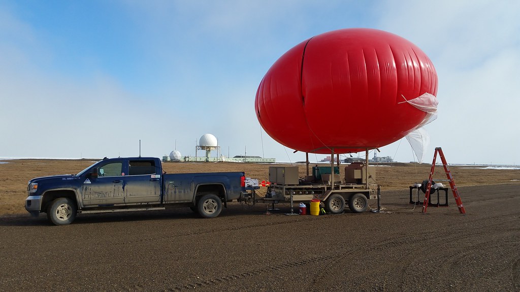
TBS have gone aloft at Oliktok Point and at ARM’s Southern Great Plains (SGP) atmospheric observatory. Lofted into the sky at altitudes up to 1.5 kilometers (0.9 miles) and stacked with large payloads of instruments, such systems offer enhanced measurements of cloud-microphysical, radiative, thermodynamic, and other properties.
“The lift is provided by the balloon,” explains Mather. “A winch and tether allow the balloon to be raised and lowered along a fixed line, without drifting away from the launch point.”
TBS have special promise in aerosol applications, especially when paired with improved instruments for collecting and profiling aerosols within a vertical column of air.
At the SGP, several TBS experiments are taking place throughout 2021. TBS will also take part in a summer 2022 intensive operational period during ARM’s TRacking Aerosol Convection interactions ExpeRiment (TRACER) in the Houston, Texas, area.
As early as 1992, ARM envisioned using TBS, but its modern TBS capability is led by Dari Dexheimer at Sandia National Laboratories in New Mexico.
“ARM has developed three TBS tailored to varied operating environments and flight missions,” says Dexheimer. “Specific recent instrumentation investments include differential GNSS (Global Navigation Satellite System) wind direction measurements, measurements of vertical wind speed, and additional POPS (portable optical particle spectrometers).”
In the arena of UAS, ARM and DOE have already benefited from small systems. The DataHawk2, for instance, with a take-off weight of about 2 pounds, can make low and slow transects over sites of interest.
“UAS have provided new perspectives, offering cost-effective in situ observations in locations where other platforms struggle for a variety of reasons,” says Colorado-based research scientist Gijs de Boer, a veteran of using such aerial systems for ARM, NOAA, and others. “ARM’s continued work to develop and enhance UAS-based instruments and the platforms that carry them allow it to remain at the forefront of addressing critical science needs and questions.”
ARM is now focused on developing mid-size UAS with payloads weighing up to about 100 pounds. The hope is that larger UAS will deliver measurements with high time and space resolution and that such systems eventually will have detect-and-avoid capabilities that allow in-cloud flying.
Meanwhile, says Mather, “we (still) see the value in small UAS and expect that users will propose to fly these systems at ARM sites.”
Improving Aerosol Measurements
To collect atmospheric data, ARM deploys more than 400 instruments on the ground and 50 on aerial platforms. But there is room for improvement and augmentation, especially of instruments related to clouds, aerosols, and precipitation.
The full range of critical aerosol size distributions, from a few nanometers to around 30 microns, is captured by instruments at the SGP. Now ARM is working on getting the same size-range capabilities to all of its atmospheric observatories.
That vision excites Allison Aiken, an aerosol scientist at Los Alamos National Laboratory in New Mexico and chair of ARM’s User Executive Committee.
“The ability to size particle growth events at the submicron scale all the way up through supermicron dust events, sea salt aerosol, and bioaerosol sources will vastly improve our understanding of aerosol-cloud interactions across the whole (ARM) facility,” says Aiken.
ARM is also determined to widen its data products related to aerosol hygroscopicity, the quantifiable tendency of a solid to absorb water, which can affect light absorption and cloud formation.
Aiken calls this water-uptake factor “an important area with a lot of unknowns, where ARM can contribute to the global understanding of aerosol impacts to the environment.”
Some ARM instruments track the chemical composition of an aerosol, but not in a way that can detail aerosol life-cycle processes. Experts are trying to fill that gap by identifying new instruments and improving offline collaborations.
Other experts are looking at ways of improving filter-based measurements of both optical absorption and ice-nucleating particles. (The filters themselves can affect such measurements.)
ARM will also augment its capability for profiling aerosols on aerial platforms and for measuring arctic aerosols at its North Slope of Alaska atmospheric observatory.
“ARM recognizes that measurement approaches must evolve to meet the continuously evolving frontier of research,” says Allison McComiskey, an aerosol scientist at Brookhaven. “ARM has always actively engaged the data user community to understand how best to do this. The priorities set forth in this new Decadal Vision reflect those community needs.”
In particular, she adds, “as aerosol process models have become more detailed, the need for aerosol microphysical and chemical properties is paramount.”
Better Cloud and Precipitation Data
Among other ARM instruments, millimeter cloud radars and video disdrometers have done heavy lifting to get measurements on clouds and precipitation. But measurement challenges remain.
Since ARM published its 2014 Decadal Vision report, Mather and scientists in the ARM user community have come up with cloud and precipitation parameters that might require new technologies and measurement priorities.
The 2021 Decadal Vision list of parameters includes:
- cloud droplet number concentration, which requires improved accuracy in remotely sensed values
- liquid water path, which in the presence of precipitation remains a significant challenge
- cloud hydrometeor phase and ice properties, with improvements ahead on deriving the detailed properties of ice
- frozen precipitation properties, which prompt the need for more work on quantifying snowfall rate and spatial variability
- vertical air motion, which is critical for studying cloud processes, but still poses challenges above clouds and getting integrated views of vertical motion
- three-dimensional cloud fields, which will require improvements in scanning cloud radars to make the best use of these workhorse instruments
- three-dimensional thermodynamic fields, which will require new measurement strategies beyond Raman lidars and spectral infrared radiometers.
Cloud and precipitation processes are also linked to surface processes and surface energy fluxes. Observing the spatial variations in surface properties represent a measurement challenge the Decadal Vision report is also taking on.
All of this requires that ARM prioritize its measurement systems. There will be cases in which ARM scales back some instruments and datastreams to make room for newer ones.
Intensive Operational Periods
Perhaps one of the most striking ideas in the Decadal Vision report is ARM’s plan to designate several annual intensive operational periods. This way, complex instruments will have guaranteed availability and will be most useful when paired with guest instruments.
The idea originated during a 2019 workshop held by ARM’s Aerosol Measurement Science Group, which McComiskey co-chairs. The group’s recent workshop report contains a discussion of aerosol intensive periods.
Scanning radars and similar instruments have significant maintenance requirements that take them out of circulation periodically. But during intensive operational periods, if ready at the same time, they could form a critical mass of measurement capabilities around targeted scientific goals. The value of measurements would then exceed those obtained during normal operations.
ARM data user Ann Fridlind, a scientist at NASA’s Goddard Institute for Space Studies in New York, pointed out in an email that since ARM’s early days in the 1990s, what ARM calls “intensive observational periods” have been a key part of its vision to complement its long-term ground-based observations.
“What is interesting and new,” she says, is that ARM is responding to science community requests to reimagine intensive operational periods that synergistically combine ARM’s complex instruments with those of guest researchers.
Fridlind says that the idea “will deliver improved science with available resources.”
The concept, she adds, “arose independently and roughly concurrently” from McComiskey’s Aerosol Measurement Science Group, as well as from ARM’s Cloud and Precipitation Measurements and Science Group, which Fridlind chairs.
Coordinated intensive operational periods fit with the spirit of the new Decadal Vision, says Mather. “They make ARM as impactful as it can be. They don’t change ARM into something new―they just increase its effectiveness.”
Multiscale Analyses
Typically, ARM observatories measure processes within single geographic points―what Mather calls “a pencil beam.”
There are exceptions, he admits, including the SGP’s extended networks of instruments, some scanning radars, and the AAF.
But in general, says Mather, “we need to find a way to bridge those spatial scales, from a column model to a few tens of kilometers.”
To get there, ARM will modify its observation strategies to increase spatial scales through what the Decadal Vision report calls “creative deployment strategies and collaboration with other measurement networks.”
This linking of scales was a significant focus of the 2014 vision report, says Mather, “and led to the development of LASSO and the concept of megasites―including the SGP boundary-layer profiling sites and even UAS and TBS operations.”
“LASSO” stands for the Large-Eddy Simulation (LES) ARM Symbiotic Simulation and Observation (LASSO) activity. LASSO combines ARM observations and LES modeling to provide a detailed picture of the atmosphere around ARM sites.
“There is more work to do in this area,” adds Mather. “We hope to continue to develop our ability to bridge scales, continuing to use the capabilities developed over the past few years while exploring other mechanisms as well.”
Bridging scales could also mean deploying subsets of instruments at a given observatory. Compact and modular observing systems could be part of ARM’s measurements future. So could multi-observatory experiments.
For certain, ARM will also add new collaborations while continuing to leverage (and possibly strengthen) old ones, such as its decades-long partnership with NASA’s AErosol RObotic NETwork (AERONET).
“We are also exploring new possible partners,” says Mather―the National Ecological Observatory Network (NEON), for instance, to boost the impact of the new ARM site in the Southeastern United States.
ARM will also step up its efforts in the sphere of making more use of satellite measurements to complement ARM’s ground-based measurements. For years, ARM has worked with NASA in that regard, but there are many new opportunities on the horizon as NASA is developing its next generation of satellite observations through its Aerosol and Cloud, Convection and Precipitation (ACCP) study.
“We are also working with operational satellite programs such as NPOESS,” he adds, referring to the new civilian-military National Polar-orbiting Operational Environmental Satellite System now under development. “We will pursue a variety of opportunities to leverage space-based observations, which provide an excellent opportunity to obtain spatial context.”
With all these data and partnerships and plans and improved instruments in hand, he says, the key to the Decadal Vision “is to develop preliminary plans, to engage with the science community to evaluate those plans, and then to progress to implementation. It’s time to think of how we’re going to turn this all into action.”
Follow Us:


Keep up with the Atmospheric Observer
Updates on ARM news, events, and opportunities delivered to your inbox
ARM User Profile
ARM welcomes users from all institutions and nations. A free ARM user account is needed to access ARM data.


