From the User Executive Committee (UEC) Subgroup Chairs: July 2022
Published: 26 July 2022
Editor’s note: In 2021, the ARM User Executive Committee (UEC) created four subgroups to continue previous work and start new efforts to broaden community outreach. In a four-part series of blogs, each subgroup chair will introduce their subgroup, share their subgroup’s ideas and recommendations to ARM, and ways in which the ARM community can engage with subgroup members. Here, Jennifer Delamere introduces the subgroup for enhancing communication with the satellite community.
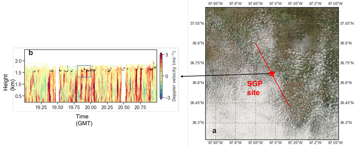
“Many of the same factors that helped create the ARM Program, including the need to better constrain climate models, also helped lead to an expansion of Earth-observing satellites,” professor Roger Marchand reminds us in the monograph that chronicles ARM’s first 20 years.
During this 30th anniversary year for ARM, we should proudly recognize that ARM collaborations with NASA and NOAA have improved the characterizations of cloud properties and thermodynamic profiles in our atmosphere. Looking toward the future with a decadal vision, ARM strives to continue this effort by identifying new satellite-based data products that provide spatial context for its fixed and mobile facilities and by developing additional collaborations with satellite programs.
With the start of the 2020–2022 ARM UEC term came the opportunity to bring focus to ARM’s interaction with the satellite community. The Enhancing Communication with the Satellite Community UEC subgroup was formed to identify strategies that meet the goals of ARM’s Decadal Vision.
The members of this UEC subgroup bring a wide array of experiences to the table, including using satellite data to infer cloud vertical motion and properties, using near-real-time satellite data to execute field campaigns, and working with ARM infrastructure to mentor instruments and create value-added products. Over a series of virtual meetings conducted from our home offices and backyards during the COVID-19 pandemic, we used our shared experiences to inform recommendations to ARM.

Recommendations to ARM
Although Instagram may have grabbed our society over the last five years, websites remain a staple of modern communication. The ARM website is a one-stop shop for all things ARM, including data resources and infrastructure descriptions.
Our subgroup asked a simple question, “How many clicks from the arm.gov site until you find a connection between ARM and satellites?” Turns out, too many!
At a wonderfully productive meeting between our UEC subgroup and the ARM communications team in June 2022, we devised a plan to add a single-page resource under the primary Capabilities tab. Following the example Modeling page, synergies between ground-based observations from ARM sites and space-based observations will be described as well as a list of satellite partners and satellite resources when you are in the field for an intensive operational period.
Beyond a new landing page, key satellite data sets for ARM could be connected through improved metadata available (e.g., cloud retrievals from SatCORPS). There is also the potential for developing a community resource web page that describes how select satellite data can be co-processed with ARM observations, perhaps with the inclusion of processing code via GitHub or interactive Jupyter notebooks.

While a website is a helpful resource, there is no substitute for engaging with partner communities. Ideally, ARM would craft a satellite liaison position. The person in this role could attend joint-agency workshops on specific quantities of interest (e.g., thermodynamic profiles or cloud retrievals), determine integral workshops in which ARM should participate, and consider how each site/deployment would benefit from sensor data on either polar-orbiting or geostationary satellites.
Until that is possible, smaller steps are being taken to strengthen ties between ARM and, for example, the NOAA Joint Polar Satellite System (JPSS) community by introducing ARM capabilities at monthly JPSS Proving Ground meetings. Similar exercises can happen with NASA initiatives.
It is also vital to engage principal investigators, ASR working groups, and site science teams on how their efforts could fuse with satellite imagery and retrievals. ARM representatives should meet with scientists at NOAA Cooperative Institutes and NASA centers that use ARM data to validate their satellite retrievals. What do these researchers find most valuable about ARM datastreams, and what gaps exist in current measurement capabilities?
Regarding ARM-sponsored field campaigns, a principal investigator should be routinely asked how available satellite sensor data and retrievals might benefit that campaign.
We’d Love to Hear From you!
Our UEC satellite subgroup would appreciate hearing from ARM data users or those in the satellite community who might have stumbled onto this blog post. What measurements could be made at ARM sites that might help you to validate your satellite retrievals? How might satellite data inform your field campaign?
Reach out to any of us on the UEC with comments, or submit ideas for future ARM capabilities on the ARM website. There is no connection too big or too small to make!
Keep up with the Atmospheric Observer
Updates on ARM news, events, and opportunities delivered to your inbox
ARM User Profile
ARM welcomes users from all institutions and nations. A free ARM user account is needed to access ARM data.


