

MAGIC
Marine ARM GPCI Investigation of Clouds (MAGIC)
1 October 2012 - 30 September 2013
Lead Scientist: Ernie Lewis
Observatory: AMF (ARM Mobile Facility) - MAG
 Clouds remain a major source of uncertainty in climate projections. In this context, subtropical marine boundary layer (MBL) clouds play a key role in cloud-climate feedbacks that are not well understood yet play a large role in biases both in seasonal coupled model forecasts and annual mean climate forecasts. In particular, current climate models do not accurately represent the transition from the stratocumulus (Sc) regime, with its high albedo and large impact on the global radiative balance of Earth, to shallow trade-wind cumulus (Cu), which play a fundamental role in global surface evaporation and also albedo. Climate models do not yet adequately parameterize the small-scale physical processes associated with turbulence, convection, and radiation in these clouds. Part of this inability results from lack of accurate data on these clouds and the conditions responsible for their properties, including aerosol properties, radiation, and atmospheric and oceanographic conditions. In MAGIC, the Marine ARM (Atmospheric Radiation Measurement) GPCI Investigation of Clouds, the second ARM Mobile Facility (AMF2) was deployed on the Horizon Lines cargo ship Spirit traversing the route between Los Angeles, California, and Honolulu, Hawaii, for one full year, from October 2012 through September 2013. AMF2's unique capabilities were utilized to observe and characterize the properties of clouds and precipitation, aerosols, and atmospheric radiation; standard meteorological and oceanographic variables; and atmospheric structure. Additionally, two intensive observational periods were conducted in January and July 2013, during which more detailed measurements of the atmospheric structure were made. This first marine deployment of AMF2 yielded an unparalleled and extremely rich data set that will greatly enhance the ability to understand and represent clouds and precipitation, aerosols, and radiation, and the interactions among them; the processes that determine their properties; and factors that control these processes. Deployment of AMF2 on a ship that routinely traverses this route provided an opportunity to collect a long-term data set over a vast cloud region which is of intense interest to climate modelers. Specifically, the transect lies closely along the cross section used for the GPCI, and the data collected provided constraint, validation, and support for this modeling effort, and for associated modeling efforts such as the CGILS and EUCLIPSE. The founders of ARM recognized the importance of these marine cloud regimes and the original document recommending locales for ARM sites explicitly called for sites in the eastern north Pacific or eastern north Atlantic Ocean. This deployment, at long last, met the identified requirement for ARM measurements in this region.
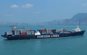
The C-9 class ship Horizon Spirit is a 268-meter (880-foot), steam-powered container ship that makes the Los Angeles-to-Hawaii run as part of the Horizon Lines fleet.
*Note: GPCI = GCSS Pacific Cross-section Intercomparison, a working group of GCSS GCSS = GEWEX Cloud Systems Study GEWEX = Global Energy and Water Cycle Experiment, a core project of the World Climate Research Programme.
Campaign Links
Related Publications
View all- Bogenschutz et al. "Exposing Process‐Level Biases in a Global Cloud Permitting Model with ARM Observations". 2025. 10.1029/2024JD043059.
Related Campaigns
- Marine ARM GPCI Investigations of Clouds (MAGIC): Bridge Display
- Marine ARM GPCI Investigations of Clouds (MAGIC): Atmospheric Optical Depth (AOD) by Microtops
- Marine ARM GPCI Investigation of Clouds (MAGIC): Ultra-High Sensitivity Aerosol Spectrometer (UHSAS)
Co-Investigators
Bruce Albrecht
Geoffrey Bland
Charles Flagg
Stephen Klein
Pavlos Kollias
Stephen Schwartz
A. Siebesma
Joao Teixeira
Warren Wiscombe
Robert Wood
Minghua Zhang
Timeline
Campaign Data Sets
| IOP Participant | Data Source Name | Final Data |
|---|---|---|
| Ernie Lewis | Ship Leg Summaries | Order Data |
| Patrick Minnis | visible infrared solar-infrared split window technique (visst) | Order Data |
| R. Reynolds | Flux Data | Order Data |
| R. Reynolds | RH Quality Assurance (Psychrometer) | Order Data |
| Gunnar Senum | Humidified Tandem Differential Mobility Analyzer | Order Data |
| Gunnar Senum | Mentor Processed Humidigraph | Order Data |
| Stephen Springston | Particle Soot Absorption Photometer - G-1 Aircraft | Order Data |
| Richard Wagener | European Centre for Medium Range Weather Forecasting | Order Data |
MAG Data Sources
| Name | Full Name | Browse Data |
|---|---|---|
AOS
|
Aerosol Observing System | Browse Data |
AOSMET
|
Meteorological Measurements associated with the Aerosol Observing System | Browse Data |
ASSIST
|
Atmospheric Sounder Spectrometer for Infrared Spectral Technology | Browse Data |
CCN
|
Cloud Condensation Nuclei Particle Counter | Browse Data |
CEIL
|
Ceilometer | Browse Data |
CEILPBLHT
|
Boundary-layer height data with CEIL | Browse Data |
CEILSHIPCOR
|
Ceilometer Corrected for Ship Motion | Browse Data |
CPC
|
Condensation Particle Counter | Browse Data |
HSRL
|
High Spectral Resolution Lidar | Browse Data |
HSRLSHIPCOR
|
HSRL Corrected for Ship Motion | Browse Data |
HTDMA
|
Humidified Tandem Differential Mobility Analyzer | Browse Data |
INTERPSONDE
|
Interpolated Sonde | Browse Data |
IRT
|
Infrared Thermometer | Browse Data |
KAZR
|
Ka ARM Zenith Radar | Browse Data |
KAZRSHIPCOR
|
KAZR Ship Motion Correction | Browse Data |
MARINEMET
|
Marine Surface Meteorological Instrumentation | Browse Data |
MPL
|
Micropulse Lidar | Browse Data |
MPLCMASK
|
Cloud mask from Micropulse Lidar | Browse Data |
MPLPOLFSSHIPCOR
|
MPL Corrected for Ship Motion | Browse Data |
MWACR
|
Marine W-Band (95 GHz) ARM Cloud Radar | Browse Data |
MWACRSHIPCOR
|
MWACR Ship Motion Correction | Browse Data |
MWR
|
Microwave Radiometer | Browse Data |
MWR3C
|
Microwave Radiometer, 3 Channel | Browse Data |
MWRRET
|
MWR Retrievals | Browse Data |
NAV
|
Navigational Location and Attitude | Browse Data |
NAVBE
|
Navigational Location and Attitude Best Estimate | Browse Data |
NEPHELOMETER
|
Nephelometer | Browse Data |
OZONE
|
Ozone Monitor | Browse Data |
PBLHT
|
Planetary Boundary Layer Height | Browse Data |
PRP
|
Portable Radiation Package | Browse Data |
PSAP
|
Particle Soot Absorption Photometer | Browse Data |
RWP
|
Radar Wind Profiler | Browse Data |
SASZE
|
Shortwave Array Spectroradiometer-Zenith | Browse Data |
SONDE
|
Balloon-Borne Sounding System | Browse Data |
SONDEGRID
|
Gridded Sonde VAP Product | Browse Data |
S-TABLE
|
Stabilized Platform | Browse Data |
TSI
|
Total Sky Imager | Browse Data |
UHSAS
|
Ultra-High Sensitivity Aerosol Spectrometer | Browse Data |
Follow Us:


Keep up with the Atmospheric Observer
Updates on ARM news, events, and opportunities delivered to your inbox
ARM User Profile
ARM welcomes users from all institutions and nations. A free ARM user account is needed to access ARM data.


