BRIDIS
Marine ARM GPCI Investigations of Clouds (MAGIC): Bridge Display
1 August 2012 - 30 September 2013
Lead Scientist: R. Reynolds
Observatory: OSC - MAG
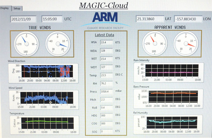
The bridge display provided a way to share AMF data with the crew in a way that helped them in their daily operations. There was a need to know the apparent winds and when filing weather reports the true winds. The bridge display used a program that is written in LabView software. It is a simple Windows 7 Pro operating system and used a bare bones PC.
Campaign Links
Related Campaigns
Co-Investigators
Ernie Lewis
Timeline
MAG Data Sources
| Name | Full Name | Browse Data |
|---|---|---|
AOS
|
Aerosol Observing System | Browse Data |
AOSMET
|
Meteorological Measurements associated with the Aerosol Observing System | Browse Data |
ASSIST
|
Atmospheric Sounder Spectrometer for Infrared Spectral Technology | Browse Data |
CCN
|
Cloud Condensation Nuclei Particle Counter | Browse Data |
CEIL
|
Ceilometer | Browse Data |
CEILPBLHT
|
Boundary-layer height data with CEIL | Browse Data |
CEILSHIPCOR
|
Ceilometer Corrected for Ship Motion | Browse Data |
CPC
|
Condensation Particle Counter | Browse Data |
HSRL
|
High Spectral Resolution Lidar | Browse Data |
HSRLSHIPCOR
|
HSRL Corrected for Ship Motion | Browse Data |
HTDMA
|
Humidified Tandem Differential Mobility Analyzer | Browse Data |
INTERPSONDE
|
Interpolated Sonde | Browse Data |
IRT
|
Infrared Thermometer | Browse Data |
KAZR
|
Ka ARM Zenith Radar | Browse Data |
KAZRSHIPCOR
|
KAZR Ship Motion Correction | Browse Data |
MARINEMET
|
Marine Surface Meteorological Instrumentation | Browse Data |
MPL
|
Micropulse Lidar | Browse Data |
MPLCMASK
|
Cloud mask from Micropulse Lidar | Browse Data |
MPLPOLFSSHIPCOR
|
MPL Corrected for Ship Motion | Browse Data |
MWACR
|
Marine W-Band (95 GHz) ARM Cloud Radar | Browse Data |
MWACRSHIPCOR
|
MWACR Ship Motion Correction | Browse Data |
MWR
|
Microwave Radiometer | Browse Data |
MWR3C
|
Microwave Radiometer, 3 Channel | Browse Data |
MWRRET
|
MWR Retrievals | Browse Data |
NAV
|
Navigational Location and Attitude | Browse Data |
NAVBE
|
Navigational Location and Attitude Best Estimate | Browse Data |
NEPHELOMETER
|
Nephelometer | Browse Data |
OZONE
|
Ozone Monitor | Browse Data |
PBLHT
|
Planetary Boundary Layer Height | Browse Data |
PRP
|
Portable Radiation Package | Browse Data |
PSAP
|
Particle Soot Absorption Photometer | Browse Data |
RWP
|
Radar Wind Profiler | Browse Data |
SASZE
|
Shortwave Array Spectroradiometer-Zenith | Browse Data |
SONDE
|
Balloon-Borne Sounding System | Browse Data |
SONDEGRID
|
Gridded Sonde VAP Product | Browse Data |
S-TABLE
|
Stabilized Platform | Browse Data |
TSI
|
Total Sky Imager | Browse Data |
UHSAS
|
Ultra-High Sensitivity Aerosol Spectrometer | Browse Data |
Keep up with the Atmospheric Observer
Updates on ARM news, events, and opportunities delivered to your inbox
ARM User Profile
ARM welcomes users from all institutions and nations. A free ARM user account is needed to access ARM data.


