AOD
Marine ARM GPCI Investigations of Clouds (MAGIC): Atmospheric Optical Depth (AOD) by Microtops
1 September 2012 - 30 September 2013
Lead Scientist: R. Reynolds
Observatory: OSC - MAG
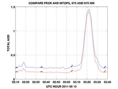
The Microtops, manufactured by Solar Light, has been proven capable of making good measurements of atmospheric optical depth (AOD) from moving platforms such as ships at sea. Dr. A. Smirnov, NASA, maintains a network of calibrated units and has provided one to the MAGIC program. Microtops data providde valuable support to the AMF2 aerosol instrumentation and the rotating shadowband radiometer.

Co-Investigators
Ernie Lewis
Timeline
MAG Data Sources
| Name | Full Name | Browse Data |
|---|---|---|
AOS
|
Aerosol Observing System | Browse Data |
AOSMET
|
Meteorological Measurements associated with the Aerosol Observing System | Browse Data |
ASSIST
|
Atmospheric Sounder Spectrometer for Infrared Spectral Technology | Browse Data |
CCN
|
Cloud Condensation Nuclei Particle Counter | Browse Data |
CEIL
|
Ceilometer | Browse Data |
CEILPBLHT
|
Boundary-layer height data with CEIL | Browse Data |
CEILSHIPCOR
|
Ceilometer Corrected for Ship Motion | Browse Data |
CPC
|
Condensation Particle Counter | Browse Data |
HSRL
|
High Spectral Resolution Lidar | Browse Data |
HSRLSHIPCOR
|
HSRL Corrected for Ship Motion | Browse Data |
HTDMA
|
Humidified Tandem Differential Mobility Analyzer | Browse Data |
INTERPSONDE
|
Interpolated Sonde | Browse Data |
IRT
|
Infrared Thermometer | Browse Data |
KAZR
|
Ka ARM Zenith Radar | Browse Data |
KAZRSHIPCOR
|
KAZR Ship Motion Correction | Browse Data |
MARINEMET
|
Marine Surface Meteorological Instrumentation | Browse Data |
MPL
|
Micropulse Lidar | Browse Data |
MPLCMASK
|
Cloud mask from Micropulse Lidar | Browse Data |
MPLPOLFSSHIPCOR
|
MPL Corrected for Ship Motion | Browse Data |
MWACR
|
Marine W-Band (95 GHz) ARM Cloud Radar | Browse Data |
MWACRSHIPCOR
|
MWACR Ship Motion Correction | Browse Data |
MWR
|
Microwave Radiometer | Browse Data |
MWR3C
|
Microwave Radiometer, 3 Channel | Browse Data |
MWRRET
|
MWR Retrievals | Browse Data |
NAV
|
Navigational Location and Attitude | Browse Data |
NAVBE
|
Navigational Location and Attitude Best Estimate | Browse Data |
NEPHELOMETER
|
Nephelometer | Browse Data |
OZONE
|
Ozone Monitor | Browse Data |
PBLHT
|
Planetary Boundary Layer Height | Browse Data |
PRP
|
Portable Radiation Package | Browse Data |
PSAP
|
Particle Soot Absorption Photometer | Browse Data |
RWP
|
Radar Wind Profiler | Browse Data |
SASZE
|
Shortwave Array Spectroradiometer-Zenith | Browse Data |
SONDE
|
Balloon-Borne Sounding System | Browse Data |
SONDEGRID
|
Gridded Sonde VAP Product | Browse Data |
S-TABLE
|
Stabilized Platform | Browse Data |
TSI
|
Total Sky Imager | Browse Data |
UHSAS
|
Ultra-High Sensitivity Aerosol Spectrometer | Browse Data |
Keep up with the Atmospheric Observer
Updates on ARM news, events, and opportunities delivered to your inbox
ARM User Profile
ARM welcomes users from all institutions and nations. A free ARM user account is needed to access ARM data.


