

New Eyes in Space to Study Earthly Clouds and Aerosols
Published: 24 May 2024
ARM is among managers of surface observatories that will validate and use new satellite data
Editor’s note (June 13, 2024): This article was originally published four days before the EarthCARE satellite’s launch. The launch from California occurred May 28, 2024, at 3:20 p.m. local time.
No earlier than May 28, 2024, at Vandenberg Space Force Base in California, the EarthCARE satellite will launch into orbit among other payloads on a SpaceX Falcon 9 rocket.
The 900-pound satellite, about the weight of a grand piano, is a joint venture between the European Space Agency (ESA) and the Japan Aerospace Exploration Agency (JAXA). Over an estimated three-year life span, its uniquely coordinated instruments will record unprecedented measurements of how energy is transmitted in Earth’s atmosphere.
The data will expand what scientists know about how the Earth’s energy budget is influenced by clouds and aerosols—tiny airborne particles that make clouds and precipitation possible.
Planetary heating and cooling, mediated by clouds and the aerosols that form them, are functions of two dynamic realities: Clouds can reflect solar radiation back into space, which has a cooling effect. Earth’s surfaces, warmed by the sun, emit infrared thermal radiation into the atmosphere that is trapped by clouds, creating a warming effect.
The largest uncertainties in global climate models are related to such cloud feedbacks. That’s partly because of the diversity of cloud types, how hard it is to measure their height and vertical extent, and the difficulty of getting the details of the individual cloud particles within them.
To help modulate these uncertainties, EarthCARE will deliver three-dimensional (3D) data to improve how clouds and aerosols are represented in global weather and climate models.
EarthCARE is the acronym for the Earth Cloud Aerosol and Radiation Explorer satellite, which took 30 years to get from conception to design to reality.
Scientists and technicians from 15 European nations, Japan, and Canada eventually took part in developing the EarthCARE package, which in March 2024 was bundled aboard an aircraft in Munich, Germany, for its flight to California.
The EarthCARE mission will start with a six-month commissioning phase and is expected to last at least two and a half years after that. In all, more than 200 research institutes worldwide are involved.
‘Extremely Valuable for Us’
“Having a satellite circling globally is extremely valuable for us. It gives us a common reference point we can use to compare what’s going on across (ARM) sites.”
ARM Director Jim Mather
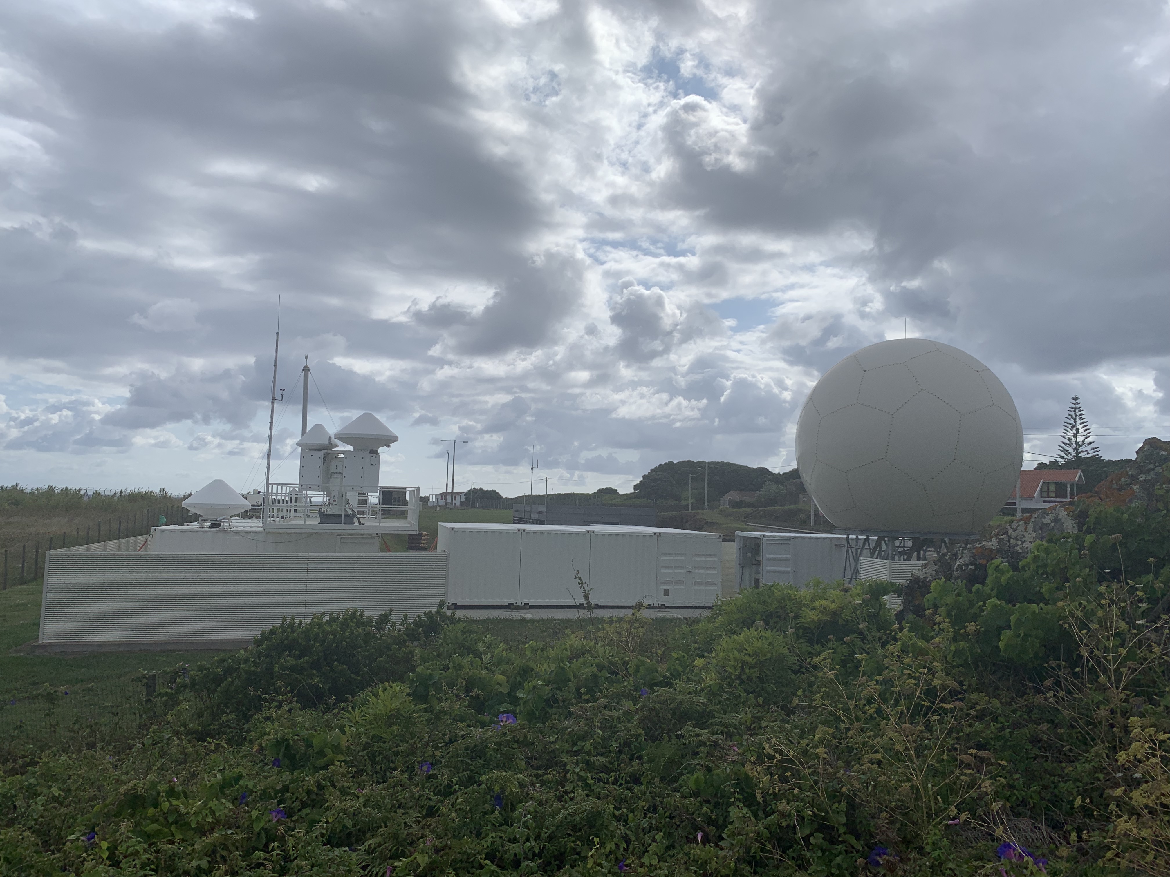
During EarthCARE’s low orbits—about one every 90 minutes, at an altitude of just under 393 kilometers, or a mere 244 miles above Earth—ground-based atmospheric observatories worldwide will help validate—quality check—the satellite’s measurements. The validation will start about three weeks after the launch. In turn, those measurements will stream into data archives around the world.
Ground-based instruments are used to validate data from satellite sensors by making sure physical measurements from space correlate with ground observations. At the same time, satellite instrumentation is valued for providing large-scale, holistic views of cloud and aerosol properties.
“It’s definitely a two-way street from a validation perspective,” says Jim Mather, an atmospheric scientist at Pacific Northwest National Laboratory (PNNL) in Washington state. “Combining those two views (of the atmosphere, from ground and space) is important.”
Mather is the director of the U.S. Department of Energy’s Atmospheric Radiation Measurement (ARM) user facility, which expects to be one of the beneficiaries of EarthCARE data.
“Having a satellite circling globally is extremely valuable for us,” says Mather. “It gives us a common reference point we can use to compare what’s going on across (ARM) sites.”
One benefit would be to use EarthCARE’s radar to cross-calibrate ARM radars, as was done with NASA’s CloudSat cloud profiling radar.
Advantages to ARM
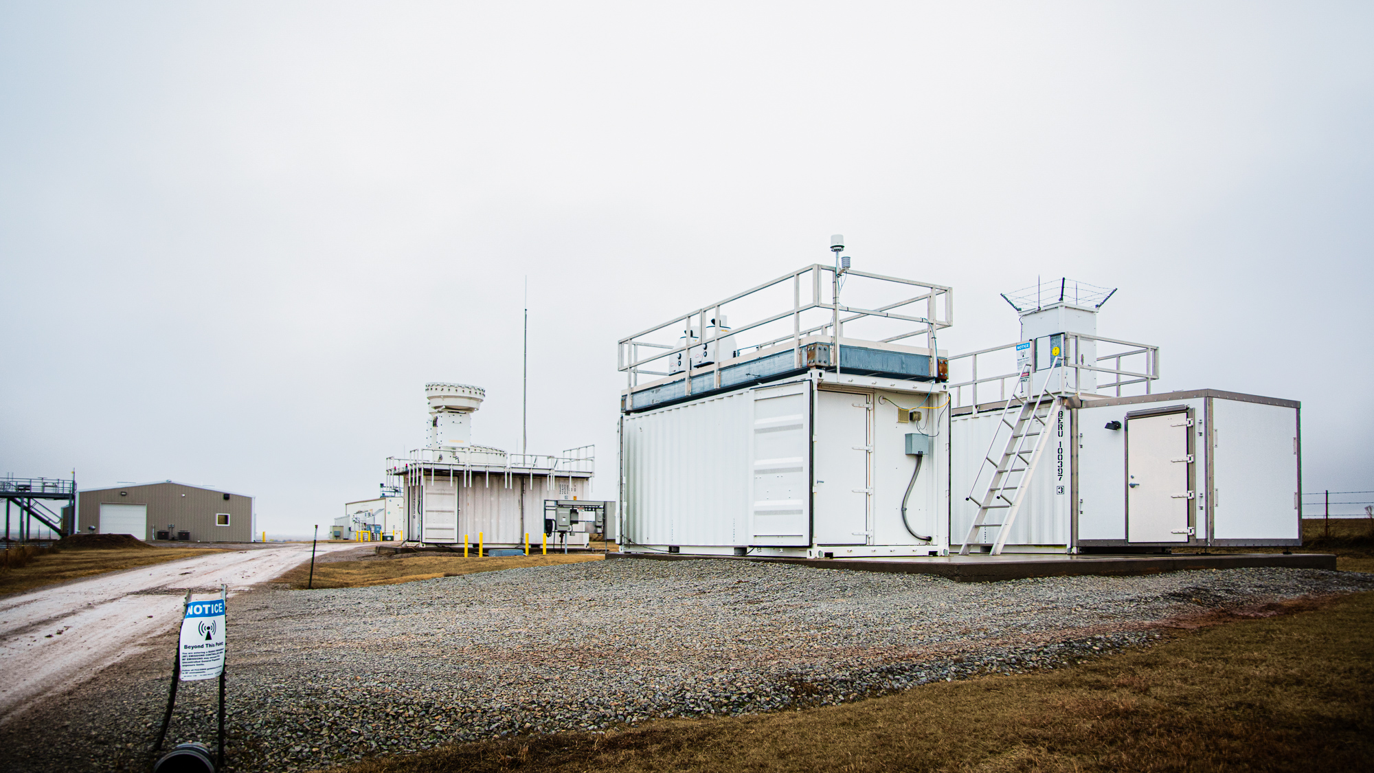
ARM operates six atmospheric observatories in climate-critical regions of the world and provides aerial capabilities. All those assets will benefit from having a new source of complementary data from space.
“Mind the gap,” a three-part series of papers from 2020 to 2022, describes the current gaps in the ability of spaceborne radars to measure cloud and precipitation systems. Two of the three lead authors, Pavlos Kollias and Katia Lamer of Brookhaven National Laboratory in New York, are radar experts and ARM data users. So is the third main author, Alessandro Battaglia of the University of Leicester (U.K.).
A related paper by Kollias, in 2023, calls the EarthCARE satellite the “most sensitive ever in orbit.”
Looking back on the “Mind the gap” series, Kollias writes that the new satellite will detect more non-precipitating clouds than CloudSat (Lamer et al. 2020); improve estimates of shallow precipitation (Battaglia et al. 2020); and, with the first 94 GHz Doppler cloud profiling radar in space, will improve microphysical retrievals (Kollias et al. 2022).
The improvements EarthCARE brings will benefit ARM—for instance, at its Eastern North Atlantic (ENA) atmospheric observatory. According to the Lamer-led paper, the EarthCARE cloud profiling radar would miss only 9% of cloudy columns detected by ENA instruments, whereas CloudSat failed to detect up to 43% of such cloud cover.
“We have the ability to compare ARM data with early data coming in from EarthCARE through a collaborative agreement,” says PNNL remote sensing expert Jennifer Comstock, who is ARM’s associate director for research.
ARM has cultivated data partnerships with many satellite platforms since the 1990s—those that operate in low-Earth orbits and those that are geostationary.
For one, 30 years ago, ARM started collaborating with the NASA Langley Research Center in Virginia, which houses a satellite data-processing system called the Satellite Cloud and Radiation Property Retrieval System (SatCORPS).
A Capable Lidar
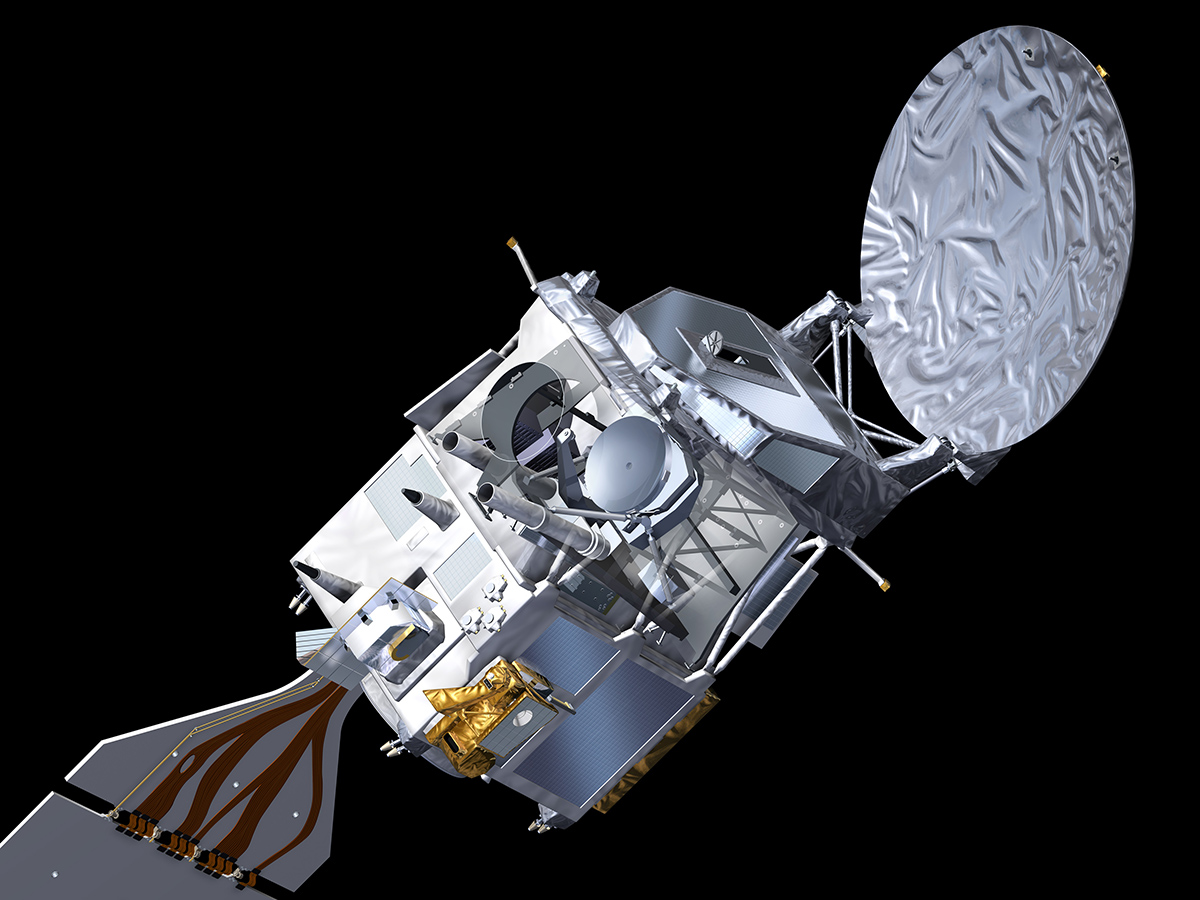
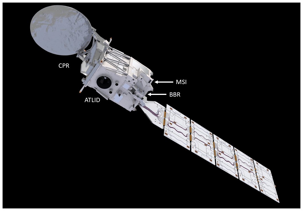
The EarthCARE satellite has four specialized instruments on board its three-axis, stabilized carbon-fiber platform. Each is customized to work in concert with the others to acquire coordinated views of clouds, aerosols, and precipitation and radiative fluxes.
One instrument is a high-spectral-resolution atmospheric lidar that uses laser light pulses to capture detailed vertical profiles of thin clouds and aerosols. It will be the first space-borne lidar that can separate light scattered by molecules in the atmosphere from the light scattered by aerosols and clouds. In this way, the new lidar can measure aerosol properties more directly.
And a bonus: the EarthCARE lidar will even help classify aerosol types.
“We haven’t really had a lidar in space with those kinds of capabilities before,” says Mather.
The predecessor to the EarthCARE lidar is the operationally similar Cloud-Aerosol Lidar and Infrared Pathfinder Satellite Observations (CALIPSO), launched in 2006. There is some evidence that the EarthCARE lidar will be better at detecting optically thinner clouds than CALIPSO, at least in daytime. This will improve how thin clouds like cirrus are represented in models.
A Sensitive Radar
A second instrument on the platform is a cloud profiling radar, which penetrates deeper into clouds than lidar. Its data will partly overlap with the lidar data to measure the vertical velocities of clouds and the concentration of particles within them. (Particle concentration is an important factor in cloud reflectivity.)
The Doppler radar’s disk-like-reflector antenna is the EarthCARE satellite’s largest feature. At the satellite’s other end is a kite-like tail of solar panels.
The EarthCARE radar will be the first cloud radar mounted on a space platform that can measure the vertical extent and motion of clouds. Its frequency, 94 GHz, is the same as that of NASA’s CloudSat.
CloudSat measured vertical extent but not Doppler velocity, says Mather, “so it could not provide (measurements of) the motion.”
The EarthCARE version of the radar will also deliver more detailed data because of its larger aperture and lower orbit.
In all, says Mather, “the EarthCARE radar will have higher sensitivity, meaning that it will be able to see smaller cloud droplets because of these factors.”
Getting Images, Detecting Radiation
Third on the carbon-fiber platform is a two-camera multispectral imager. It will provide visual context for the lidar and radar measurements, sweeping up views as wide as 150 kilometers (93 miles) across.
Lastly, a broadband radiometer will get to planetary energy balance, the core of the mission. It uses three fixed telescopes to measure the solar and thermal radiation reflected and emitted from Earth’s surface, atmosphere, and clouds.
Putting all these measurement sources together gives researchers a way to “look at all these (atmospheric) systems in a unified way,” says Mather. “It’s very powerful.”
Data Interoperability

If that “unified way” is to have any power, atmospheric scientists across the world must agree on ways to harmonize data.
That effort is well underway, says Giri Prakash of Oak Ridge National Laboratory in Tennessee, who oversees the ARM Data Center.
ARM data service experts, he says, “are considered leaders in sharing data and using community standards and protocol.”
Prakash and his ARM data team started developing data-sharing capabilities several years ago to make ARM data interoperable. He is confident that EarthCARE will be able to make use of ARM’s data-sharing capabilities.
At the same time, EarthCARE ground validation will drive data sharing and interoperability forward, making it easier for scientists to use data across observatories worldwide.
Prakash is working on ways to make data interoperable and harmonized by developing mutually transferable formats.
“It’s critical that we make our data available to our user community,” says Prakash, but also to “other relevant science communities such as EarthCARE.”
Using one common language for all varieties of observational data is impossible; it would mean losing the subtleties of measurement, says Prakash. “What you want instead are cross-domain ontologies and crosswalks.”
In information science, “ontologies” describe relationships between concepts and data.
Eventually, says Prakash, artificial intelligence will be used to “expedite interoperability” among atmospheric science’s wildly diverse field data, creating something that is “commonly consumable to a broader global network.”
ARM and ACTRIS
“We are actively looking for ways that ARM and ACTRIS can work together to share knowledge around topics such as instrument calibration, data processing, data sharing, open-source resources, and interoperability.”
ARM Associate Director for Research Jennifer Comstock
In mid-May, Prakash and Comstock attended a four-day international science conference in Rennes, France, sponsored by the Aerosol, Clouds and Trace Gases Research Infrastructure (ACTRIS). This pan-European research infrastructure coordinates atmospheric data collection in 22 countries. Among other things, the group harmonizes and shares data sets on atmospheric processes.
For ACTRIS, says Prakash, ARM is the lead contributor for data sharing, including the creation of metadata standards and a “data citation strategy” that makes sure data sources are credited.
ARM has made about 40 of its datastreams available to ACTRIS. During the May conference, Prakash chaired a session on data sharing and interoperability. Before leaving for France, he predicted that ACTRIS will be “the primary data provider” for EarthCARE.
Mather agrees, saying that ACTRIS and EarthCARE “are hard to untangle.”
In France, Prakash and Comstock spent part of the time networking on behalf of ARM to increase its visibility within the ACTRIS community.
“We are actively looking for ways that ARM and ACTRIS can work together,” says Comstock, “to share knowledge around topics such as instrument calibration, data processing, data sharing, open-source resources, and interoperability.”
First, Southern Great Plains
ARM is among a “big network of like facilities and observatories that will take part in EarthCARE satellite validation projects,” says Mather.
During the satellite mission’s commissioning phase, radars and lidars at ARM’s Southern Great Plains atmospheric observatory in Oklahoma will help validate EarthCARE measurements.
After that, there is the potential for aligning ARM radars and lidars at other ARM sites with EarthCARE, according to a November 2023 presentation by Mather.
During EarthCARE’s operational phase, which is scheduled to start in late 2024, ARM and other entities will draw data from the platform.
The operational phase, when publicly available data products become available through centers in Europe, will last at least into the spring of 2027.
A Touch of Tasmania
One of the first EarthCARE data consumers and validators will be Matthew Lebsock from NASA’s Jet Propulsion Laboratory in California. He is leading a small ARM field campaign called EarthCARE Validation at CAPE-k (EVCK), slated to begin in October 2024 in Tasmania.
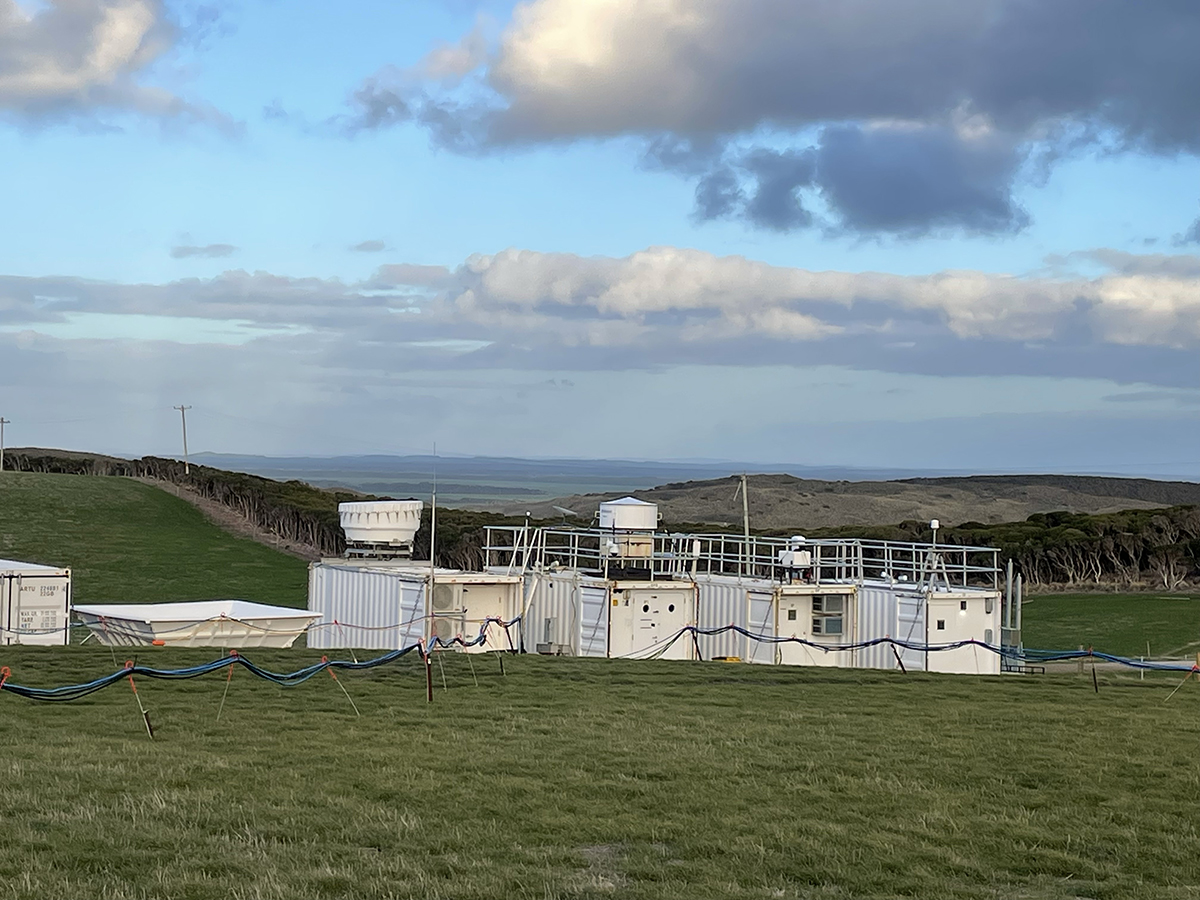
CAPE-k—short for the Cloud And Precipitation Experiment at kennaook—is collecting measurements on a remote, windswept peninsula. Beyond is the vast Southern Ocean, where data on clouds, aerosols, and precipitation are sparse.
At the CAPE-k site, Lebsock and his team will deploy a new minimalist, low-cost modular radar system called CloudCube alongside ARM’s Ka- and W-band radars. CloudCube will measure a full year’s cycle of precipitation and cloud phases.
The NASA-funded G-band cloud Doppler radar will take measurements within the lowest 200 meters (656 feet) of the atmosphere, where the ARM radars have blind zones.
CloudCube will also deliver precise data on wind speeds and (combined with the ARM radars) will record very small droplet sizes when precipitation occurs.
EVCK’s main mission, says Lebsock, is to provide EarthCARE satellite validation data on precipitation and near-surface clouds, “which cannot be evaluated by the (ARM) instrumentation alone.”
To Comstock, EVCK illustrates “the type of (EarthCARE) validation we could do.”
To Mather, Lebsock’s campaign illustrates the convening power of Earth-orbit satellites.
EarthCARE will bring together “discrete and very comprehensive views,” he says, “little clusters of instruments in different locations around the world.”
Follow Us:


Keep up with the Atmospheric Observer
Updates on ARM news, events, and opportunities delivered to your inbox
ARM User Profile
ARM welcomes users from all institutions and nations. A free ARM user account is needed to access ARM data.


