

CAPE-k Gets Underway
Published: 7 May 2024
For 17 months, a field campaign in Tasmania will collect unprecedented data on Southern Ocean aerosol-cloud-precipitation interactions
Imagine this.
Date, place, mission.
April 15, 2024.
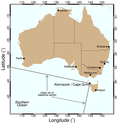
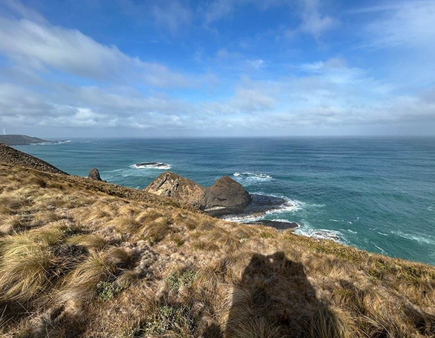
Wind blows across a barren peninsula called kennaook / Cape Grim on the northwestern coast of Tasmania, an island state in Australia.
Thick clouds hang like curtains. A weather balloon launcher the size of a small house sits on an asphalt pad.
At 9:30 a.m., two rooftop doors on the launcher open like wings. A large white helium-filled balloon pops into the air, dangling a small instrument package called a radiosonde. Swaying upward on a strong breeze, the balloon rides into the sky over open water.
Soon, the radiosonde begins transmitting data on atmospheric temperature, pressure, and humidity back to computers on land.
Welcome to the start of the Cloud And Precipitation Experiment at kennaook (CAPE-k). The 17-month field campaign has begun collecting measurements of some little-known atmospheric conditions and processes over the climate-critical Southern Ocean.
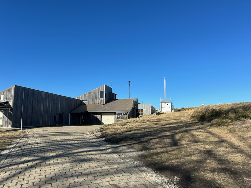
The site for CAPE-k is apt: the Kennaook / Cape Grim Baseline Air Pollution Station, which has collected continuous data on atmospheric composition since 1976.
Why CAPE-k, and why now?
The answer lies in another question: How sensitive is the planet’s climate to global warming? To find out, scientists need to create better predictive models, says CAPE-k Co-Principal Investigator Gerald “Jay” Mace of the University of Utah. “What motivated CAPE-k was understanding processes in the Southern Ocean that the warming climate is most sensitive to.”
To date, what scientists know about cloud and aerosol properties over the Southern Ocean is largely from satellite data sets and a scattering of ship-based efforts. A sustained, long-term campaign like CAPE-k will help expand atmospheric data in a region that Australian atmospheric chemist Melita Keywood calls “the most under-observed in the world.”
Mace is hopeful, saying that “CAPE-k will answer some of the fundamental questions about the seasonality of cloud and precipitation processes in the Southern Ocean.”
Confronting Model Uncertainties
CAPE-k is supported by the U.S. Department of Energy (DOE) with help from the Australian Bureau of Meteorology (BOM) and the Commonwealth Scientific and Industrial Research Organisation (CSIRO), Australia’s government agency for scientific research.
BOM and CSIRO jointly manage the air pollution station that is hosting CAPE-k.
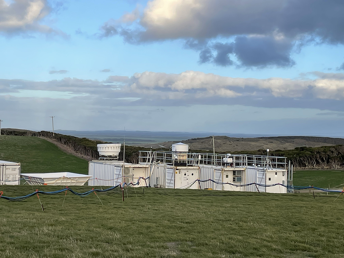
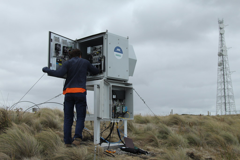
The campaign’s core instruments arrived in a multi-container mobile observatory operated by DOE’s Atmospheric Radiation Measurement (ARM) user facility.
ARM, whose own data go back more than 30 years, maintains three fixed and three mobile observatories in climate-critical regions of the world.
ARM’s delivery to the CAPE-k site included instrument shelters, a guest Aerosol Observing System, two micropulse lidars, a data system, and—rare in this part of the world—two cloud radars. BOM loaned ARM the automated radiosonde launcher for CAPE-k.
By late February 2024, ARM’s array of instruments was in place. By March 15, data verification began—a kind of dry run of how CAPE-k instrumentation would operate in concert with the air pollution station’s instruments.
“The Earth is warming (based on) established scientific facts,” says Mace, citing predictive global climate models. “But we don’t know how realistic those predictions are.”
One big source of uncertainty in such models is how much clouds contribute to predicted warming. That uncertainty includes seldom-measured cloud and precipitation processes over the Southern Ocean.
Combining Campaign Data
The Southern Ocean, though smaller than the Pacific, Atlantic, and Indian oceans, has a large influence on global climate. It plays a central role in taking up heat and much of the world’s emitted carbon dioxide, and it has a profound effect on global ocean circulations.
Meanwhile, currents in the Southern Ocean rotate around Antarctica, setting up mirror circulations in the atmosphere. These circulations create “a train of synoptic storms that run around the continent,” says Mace. “You wind up with an environment where cloud cover is (abundant), winds are strong, and the annual growth and contraction of ice cover is extraordinary.”
Most Southern Ocean field campaigns are relatively brief and provide limited data, says Mace. For example, ship-based campaigns typically cover just one season, and a ship’s motion tends to skew measurements.
Ship-based efforts in the region have produced great data sets, however.
Mace offered a 2017–2018 ARM field campaign as an example: Measurements of Aerosols, Radiation, and Clouds over the Southern Ocean (MARCUS). For about five months, ARM instruments operated on a supply vessel making regular trips to resupply research stations in Antarctica. MARCUS sensors recorded rare aerosol and cloud property measurements from spring to autumn, mostly in sparsely observed latitudes poleward of 60 degrees south.
Roger Marchand, a MARCUS co-investigator from the University of Washington, is Mace’s co-principal investigator for CAPE-k.
From 2016 to 2018, Marchand led ARM’s land-based Macquarie Island Cloud and Radiation Experiment (MICRE). It was designed to improve how global climate models represent Southern Ocean cloud, aerosol, and surface radiative properties.
“In the long run, the data collected at CAPE-k will be combined with that collected during MICRE and shorter ship- and aircraft-based experiments, as well as satellite data sets,” says Marchand. “Together, such data will create an increasingly holistic understanding of Southern Ocean clouds and cloud-aerosol interactions.”
Mace agrees.
In the end, “we’ll have a real extensive record,” he says. “In some sense, these experiments all tie together.”
A Data Ally
Earlier campaigns aside, CAPE-k has a strong data ally in the region.
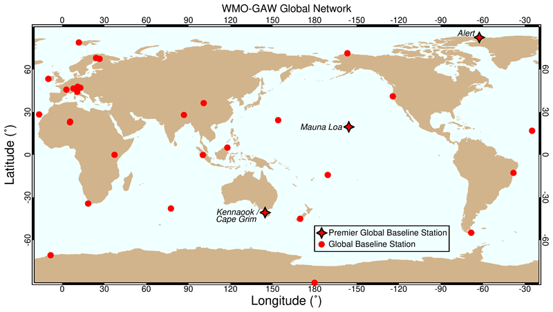
The Kennaook / Cape Grim Baseline Air Pollution Station has collected almost a half-century of aerosol and trace gas measurements. It is also only one of three “premier” installations among over 500 worldwide that form the World Meteorological Organization-Global Atmosphere Watch (WMO-GAW) network.
“Premier” stations are larger and better equipped than others. The other two are in Hawaii and the Canadian Arctic.
WMO-GAW stations measure trace gases, other ozone-depleting gases, reactive gases, and aerosols.
So many years of data on aerosols are wonderful, says Mace. “Now the goal (of CAPE-k) is to connect the aerosols to the clouds.”
The Draw of Pristine Air
It is true that the air pollution station offers a long history of comprehensive data sets, including those in the world-renowned Kennaook / Cape Grim Air Archive, making the site attractive for CAPE-k.
This remote peninsula is also attractive because of its extraordinarily clean air.
For up to 40% of the time, the air at kennaook / Cape Grim is among the most pristine in the world—“as pure as you can get,” says Mace, another sign that the Southern Ocean is “the last great wilderness” on Earth.
Climate modelers are glad to have data on pristine marine baseline air conditions as a proxy for preindustrial atmospheric conditions.
Researchers define baseline conditions as air reaching kennaook / Cape Grim from a defined sector southwest of Tasmania after a long trip over the Southern Ocean and, says Keywood, as “air that has very low traces of gases from land influence, like radon.”
Keywood co-wrote a 2023 paper with Australian atmospheric scientist Ruhi Humphries on seasonal changes in Southern Ocean aerosols. It touched on the meaning of being able to measure preindustrial atmospheric conditions.
“If you’re trying to understand the impact humanity has had on the Earth,” says Humphries, “you want to know what the (atmospheric) state was before that, and you need to quantify it.”
Humphries and Keywood, both CAPE-k co-investigators, co-direct CSIRO’s scientific oversight of the aerosol measurement program at the Kennaook / Cape Grim Baseline Air Pollution Station.
Across CSIRO’s air-related research programs, scientists analyze the station’s data on trace gases, ozone-depleting substances, and reactive gases. They also investigate aerosol optical depth, which determines how much solar energy reaches the Earth’s surface, and cloud-nucleating particles.
Such bits of matter, thought to be sparse in the Southern Ocean compared with northern oceans, help form water droplets and ice in clouds. Some research indicates that such particles may increase in the Southern Ocean as the climate warms, sea ice retreats, and phytoplankton activity increases.
From the air pollution station data, CSIRO works with other researchers to develop mathematical simulations of atmospheric conditions over the Southern Ocean.
Cloud, Precipitation, and Radiation Data
The archive of data from kennaook / Cape Grim is impressive, says Humphries, but there is a further need for “a strong cloud observational program.”
The opportunity to get a year and a half of Southern Ocean data drew CAPE-k researchers to the site in Tasmania, where ARM brings cloud radar and considerable lidar resources to the table.
Lidar uses pulsed light beams to detect even the thinnest clouds and record their height. It can also obtain profiles of solar radiation being scattered from aerosols and precipitation below clouds.
Cloud radars use microwaves to reveal a cloud’s water content, particle distribution, and vertical internal structure.
ARM radar and lidar measurements, combined with data from other instruments, will shed light on the physical and radiative properties of Southern Ocean clouds.
ARM assets include a marine atmospheric emitted radiance interferometer, which measures infrared spectral radiance; and a suite of passive radiometers stretching from the visible, through the infrared, and into the microwave wavelength ranges.
In addition, the WMO-GAW instruments already in place at kennaook / Cape Grim will help researchers understand how clouds and aerosols interact. These instruments have historically focused on aerosol properties, says Keywood, and are not meant to take comprehensive measurements of cloud properties.
For one, most of the instruments are only 10 meters (32 feet) above kennaook / Cape Grim’s 90-meter (295-foot) clifftop. The area’s cloud height can be 20 times higher than that.
The site has a 70-meter (230-foot) tower, but it is devoted to communications and collecting trace gas data, not data on cloud processes.
Data at Sea
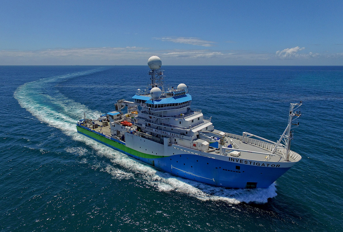
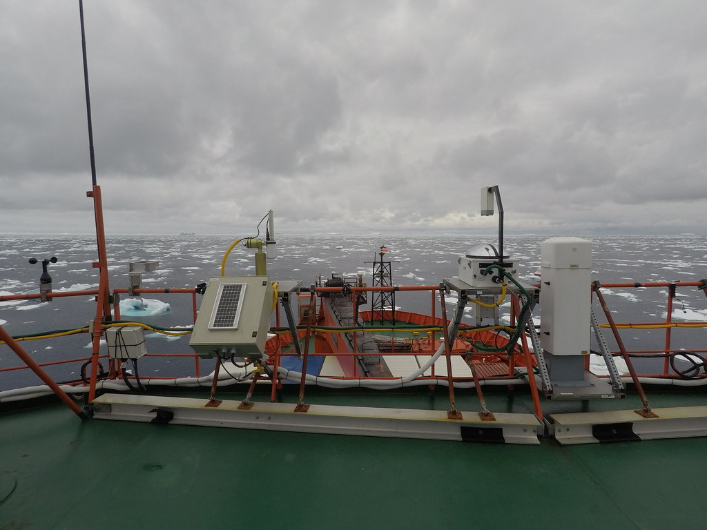
During CAPE-k, cloud and precipitation data will also be collected at sea aboard the research vessel Investigator, owned and operated by CSIRO.
In 2018, the 94-meter (308-foot) diesel-electric ship became the first mobile observation platform in the WMO-GAW program. At sea, it can accommodate 20 crew members and 40 science passengers for up to 60 days without resupply.
During May 2025, the Investigator will undertake a three-week voyage led by CAPE-k scientists. The effort is dubbed Clean Ocean Air Sampling upwind of Tasmania-kennaook (COAST-k).
“It will amble offshore next to kennaook / Cape Grim,” says Humphries, in part to complement CAPE-k observations.
“We’ll bring a whole suite of similar instrumentation,” says Mace of the attempt to validate and compare data acquired from instruments on land at kennaook / Cape Grim. “That’s huge.”
NASA will also use COAST-k to validate satellite data.
COAST-k will align with the last of four intensive operational periods (IOPs) during CAPE-k. Two are planned for 2024 and two for 2025. The first IOP began May 1, 2024, and will last several weeks.
During IOPs, to support modeling studies, CAPE-k technicians will step up the pace of radiosonde launches to eight a day in baseline air conditions. The radiosondes will collect additional data profiling temperature, pressure, and humidity.
Meanwhile, CAPE-k will host guest instruments, including some from the Queensland University of Technology in Australia, the Karlsruhe Institute of Technology in Germany, and the universities of Leeds and York in England.
A Taste of MISO
Mace is an Investigator veteran. In January 2024, he joined 38 other scientists for a CSIRO-sponsored voyage dubbed Multidisciplinary Investigations of the Southern Ocean (MISO). The ship traveled about 12,000 kilometers (7,500 miles) to collect samples from the Southern Ocean and its atmosphere. At 65 days, it was the research vessel’s longest voyage so far.
MISO and CAPE-k “are both investigating very similar science,” says Humphries, including aerosol and cloud properties that are “naturally derived (and) largely a function of emissions from ocean biology.”
Humphries co-authored a 2023 study untangling the interlocking influences of Southern Ocean organisms, aerosols, precipitation, clouds, and radiation. The paper “summarizes the big science questions,” he says, including those at the heart of CAPE-k’s mission.
During MISO, scientists took measurements of seawater iron, deep-ocean carbon dioxide, salinity profiles, water-column sediments, and marine organisms.
The voyage also took in measurements of aerosols, clouds, and precipitation of the kind CAPE-k will collect.
“We did a huge transect around the Southern Ocean,” says Mace. “But it was only January and February,” during the Southern Hemisphere’s summer. Because of CAPE-k’s length, he adds, “We will see big seasonal swings that we couldn’t have gotten from the ship.” And there is just no question: “We’re going to find extreme differences in cloud properties from summer to winter.”
The prospect of getting a historic data set on the Southern Ocean from CAPE-k is compelling and attractive. But so is kennaook / Cape Grim itself, says Mace, a lifelong outdoorsman.
“This place is very wild,” he says. “It draws people like me.”
Please note: kennaook is lowercased in the campaign’s full name, and the k is lowercased in the acronym to honor aboriginal practices in lutruwita / Tasmania. Kennaook is capitalized when referring to the baseline air pollution station. When writing the dual name, please use a spaced forward slash to separate the two parts of the name (kennaook / Cape Grim).
For more information on CAPE-k, read a May 6, 2024, news release on CSIRO’s website.
Follow Us:


Keep up with the Atmospheric Observer
Updates on ARM news, events, and opportunities delivered to your inbox
ARM User Profile
ARM welcomes users from all institutions and nations. A free ARM user account is needed to access ARM data.


