

Help From On High
Published: 24 June 2019
A federal partnership captures the layered synergy of space, aircraft, and ground observations
Let’s say you are an atmospheric scientist and use a lot of data from the Atmospheric Radiation Measurement (ARM) user facility.
You know that ARM, funded by the U.S. Department of Energy (DOE), provides comprehensive measurements from the ground—but that such measurements offer limited spatial information and do not provide a top-of-atmosphere view.
Let’s add that your research requires knowledge of cloud conditions over hundreds of kilometers: just the kind of large-scale view that ARM—for all its strengths—cannot provide.
In all these ways, observations from satellites—Earth-orbiting instrument platforms—are an important data complement to ARM measurements.
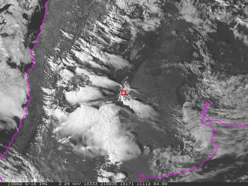
For atmospheric scientists, linking sources of ground-and-space data makes a lot of sense. To that end, for 25 years, ARM has collaborated with the NASA Langley Research Center in Virginia, which houses a satellite data-processing system now called the Satellite Cloud Observations and Radiative Property retrieval System (SatCORPS).
Among other tasks, SatCORPS produces satellite retrievals of radiation and cloud properties over and around ARM atmospheric observatories and during ARM field campaigns. Together, these sky and ground observation systems help provide a more complete picture of the atmospheric column.
“NASA takes those observations and applies corrections and algorithms to produce easily usable products,” says Adam Varble, a scientist at Pacific Northwest National Laboratory (PNNL) in Richland, Washington, who uses ARM data.
Data from NASA’s Langley group are available from the ARM Data Services—generally within 48 hours of when they are collected.
Yet despite the speed and logic of such coordinated satellite data, says ARM Technical Director Jim Mather, “I get the sense this is an undervalued data set. Many of the newer researchers may not be aware of it.”
Ground-Sky Partnership
SatCORPS has other clients, of course, including the National Weather Service, global modeling centers, and industry.
“They all need information on clouds,” says SatCORPS principal investigator William L. Smith.
ARM, however, was the first client, and has a special place in the history of NASA satellite measurements.
“SatCORPS was conceived and developed as a result of our interaction with ARM,” says Smith. “We were trying (in the 1990s) to provide support in real time for their field campaigns and to develop real-time tools to ingest and analyze satellite data.”
Naming
Today, the SatCORPS tool that is perhaps most useful to ARM data users is the visible infrared solar-infrared split window technique (VISST), the main daytime algorithm employed in the SatCORPS suite.
For ARM data users, there is a unique link. In addition, the VISST cloud products page links to an alternate way of accessing the VISST datastream.
VISST is just one of a suite of algorithms available through SatCORPS, which is managed by a group within the Climate Science Branch at Langley.
What’s in a name? In this case, a lot.
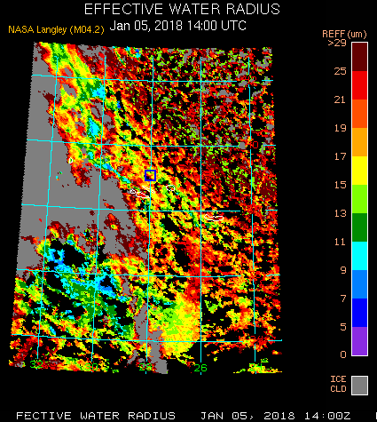
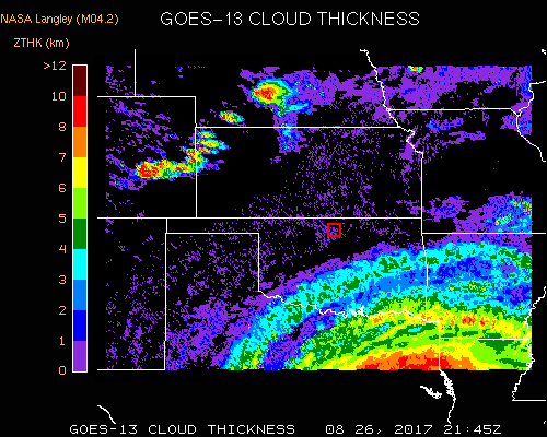
Colloquially, the term VISST has come to represent an entire suite of algorithms that uses real-time and near-real-time imagery from a variety of satellites. The algorithms derive information about clouds, including their location, altitude, and optical and microphysical characteristics.
Calling the whole suite “VISST” provided a quick way of referring to the products. The name encompasses all the algorithms in the suite, which also include SIST (Solar-infrared Infrared Split-Window Technique) and SINT (Solar-infrared Infrared Near-Infrared Technique).
The “SatCORPS” name itself was coined around 2015 to describe this suite of algorithms more completely and as a naming convention for journal articles.
Ground-Truth Data
“ARM sites are providing ground-truth data we use all the time for validating satellite-derived products.”
William Smith, SatCORPS principal investigator
VISST and the other algorithms employ theoretical radiance calculations for a wide range of cloud conditions. SatCORPS scientists infer cloud properties that yield the best agreement between calculated and observed radiances.
SatCORPS distributes data sets as images and as digital data files in the Network Common Data Form (netCDF), so they are ready for data mining by researchers.
“We derive a lot of benefit from the ARM facility,” says Smith. “ARM sites provide ground-truth data we use all the time for validating satellite-derived products.”
Data from the ARM observatories, he adds, also help SatCORPS tune its algorithms.
The same NASA scientists work with ARM and DOE’s Atmospheric System Research (ASR) program, says Mather, to “identify the highest data priorities at any given time.”
Special Products
Smith’s Langley group draws data from ARM’s stationary and mobile observatories, as well as from ARM field campaigns. For those, the group develops a special suite of products, focuses on a field campaign’s domain, and sometimes adjusts the spatial or time resolution of the data.
PNNL’s Varble provided an example from a recent seven-month ARM field campaign he led in Argentina as principal investigator: Cloud, Aerosol, and Complex Terrain Interactions (CACTI).
“For CACTI, Kris Bedka at Langley ran his convective products algorithm,” says Varble. “That identifies regions and properties of storm updrafts that overshoot—go higher and get colder—than their surrounding anvil cloud.”
The CACTI team now has rapid-scan data at a 1-minute resolution for many CACTI events. Typically, such data is only saved every 15 minutes over South America—and every 5 minutes over the continental United States.
Satellite data help with a primary concern: being able to detect clouds, pinpoint where they are located, and calculate how often they occur.
These data also help determine the altitude and depth of clouds, how reflective they are, their temperatures, the density of water in them, and their cloud phase. (A cloud’s phase—whether it is predominantly liquid, ice, or a mix of the two—strongly influences radiative impact.)
Harmonizing Data From Ground and Sky
For almost two decades, NASA’s SatCORPS team has generated and distributed the satellite-derived cloud-retrieval data sets important to ARM users. Such data are a synergistic match with measurements from ARM observatories.
ARM provides long-term cloud and radiative data in climate-critical areas of the world. In addition to its fixed observatories, ARM deploys short-term portable observatories for campaigns. The resulting short- and long-term ground data are valuable for monitoring climate-related parameters.
Meanwhile, SatCORPS algorithms use imagery acquired from both geostationary and low-earth-orbit satellites.
Integrating ARM ground-based measurements with satellite data “provides a more complete description of the atmospheric column,” says Shaocheng Xie, ARM data products and translators lead from Lawrence Livermore National Laboratory in California.
For instance, he says, VISST-derived radiative fluxes at the top of the atmosphere help make the large-scale forcing estimates that support ARM and ASR cloud modeling studies.
“There is no perfect observation system,” cautions Smith. “Certainly what we measure from space isn’t perfect. Certainly what we measure from a single point at a ground station isn’t perfect either.”
Still, that’s the beauty of the ARM-Langley collaboration, he says. “It’s important to be able to integrate all these things—to define the state of the atmosphere as best you can, synergistically.”
Deploying Algorithms
The SatCORPS team deploys the algorithms (there are many, for analyzing data from many satellites), generates the data sets, and delivers them to ARM and other clients. The team starts with the spectral radiances measured from each satellite and translates them into geophysical products.
To “translate” includes ways of classifying cloud-related characteristics for an array of pixels around a target site, and how best to stage the data products for users. (Mather urges researchers with specific data needs “to let ARM or ASR management know.”)
With customized pixel counts and grid sizes, the SatCORPS team also produce data products to better support a wide range of client needs.
Progressions
“(With ARM), we’re still using each other’s data to make advances in understanding climate and improving satellite retrievals.”
Smith
In 1994, at the time of the first ARM-Langley collaborations, a satellite called GOES-7 had just two cloud imaging channels: one for the visible band and the other for infrared. The next generation of satellites progressed to five-channel imagers. Today, a third generation has up to 16 channels.
SatCORPS algorithms have progressed in tandem with satellite technology. They now include, for instance, new ways of distinguishing clouds from dust and heavy aerosols.
“We’re still growing,” says Smith. “We’re still improving. (With ARM), we’re still using each other’s data to make advances in understanding climate and improving satellite retrievals.”
The future means continuing to work in tandem with ARM, he adds. “This is a relationship and a collaboration we hope continues for a long time.”
Follow Us:


Keep up with the Atmospheric Observer
Updates on ARM news, events, and opportunities delivered to your inbox
ARM User Profile
ARM welcomes users from all institutions and nations. A free ARM user account is needed to access ARM data.


