Using ARM Cloud Data to Evaluate the Effect of a Land Surface on Clouds
Submitter:
GSFC, NASA — NASA GSFC
Area of research:
Cloud Distributions/Characterizations
Journal Reference:
Zeng, X., W.-K. Tao, M. Zhang, C. Peters-Lidard, S. Lang, J. Simpson, S. Kumar, S. Xie, J. L. Eastman, C.-L. Shie, and J. V. Geiger, 2007: Evaluating clouds in long-term cloud-resolving model simulations with observational data. J. Atmos. Sci. (in press).Science
Cloud representation is one of the most important uncertainties in global climate models (GCMs). Since clouds are coupled with their underlying surface, it is interesting to explore how to represent the coupling between clouds and the land surface in GCMs. High-quality cloud data collected at the Atmospheric Radiation Measurement (ARM) Climate Research Facility (ACRF) Southern Great Plains (SGP) site provide an opportunity to evaluate the effect of a land surface on clouds together with the aid of a high-resolution cloud-resolving model (CRM).
Impact
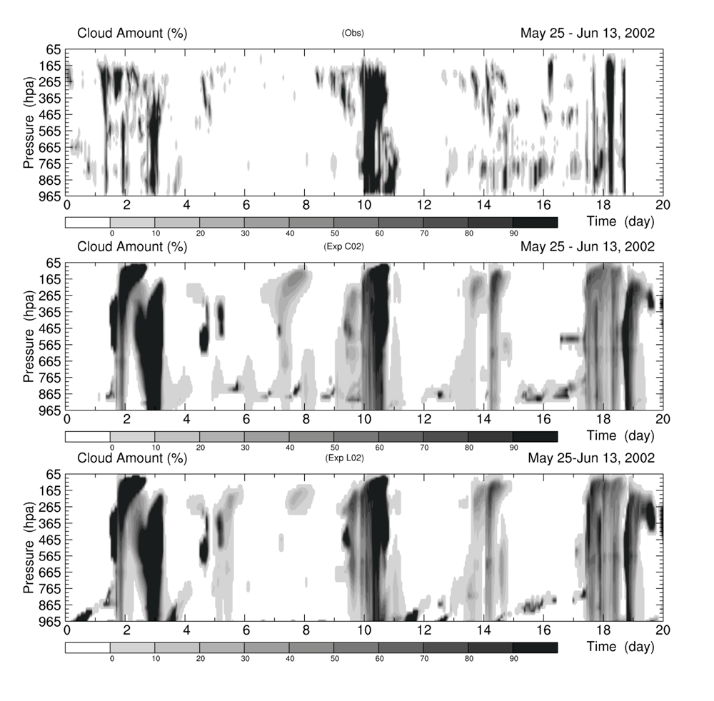
The Goddard Cumulus Ensemble (GCE) model, a CRM, was used to model summertime clouds over the SGP site, and the results were compared with ARM cloud observations (Zeng et al. 2007). High-density energy balance bowen ratio (EBBR) stations provided surface fluxes to the model. For comparison, the National Aeronautics and Space Administration (NASA) land information system (LIS), a land data assimilation system with 1-km horizontal resolution also was used to provide surface fluxes for cloud simulations. Figure 1 displays the observed and the modeled cloud amount for comparison. There is a strong diurnal variation of modeled cloud amount from day 4 to 9, when the ARM surface fluxes are used but not when the LIS fluxes are used. This cloud amount difference coincides with a difference between the ARM and LIS surface fluxes from day 4 to 9.
Summary
Since the number density of the EBBR stations is high, this modeling result suggests that it is necessary to properly represent the coupling between clouds and a land surface on a sub-grid scale in GCMs.


