

Revisiting Antarctica’s AWARE
Published: 22 February 2024
Concerns today spark reflections on an ARM campaign whose data from West Antarctica remain uniquely useful eight years later
A 2023 article in Nature Climate Change sparked a flurry of news reports on scientific concern over the fate of ice in Antarctica.
The authors note that oceans are warming at three times the historical rate. During the 21st century, they argue, it is “inevitable” that vulnerable ice shelves in West Antarctica will melt at an accelerating rate.
If the West Antarctic Ice Sheet (WAIS) fully melted, the global mean sea level would rise by more than 17 feet. Scientists regard the WAIS as a major potential tipping point in earth system behaviors.
Renewed attention to antarctic ice melting is a reminder that, eight years ago, intrepid U.S. researchers took part in a 14-month field campaign conducted in West Antarctica by the Atmospheric Radiation Measurement (ARM) user facility. Managed by the U.S. Department of Energy (DOE) Office of Science, ARM operates fixed-location and mobile atmospheric observatories in climate-critical regions around the world.
To this day, the ARM West Antarctic Radiation Experiment (AWARE) remains “the single largest atmospheric and climate science field program ever sent to Antarctica,” says AWARE Co-Principal Investigator Dan Lubin. “That’s in terms of the sheer number and sophistication of the instruments that were deployed.”
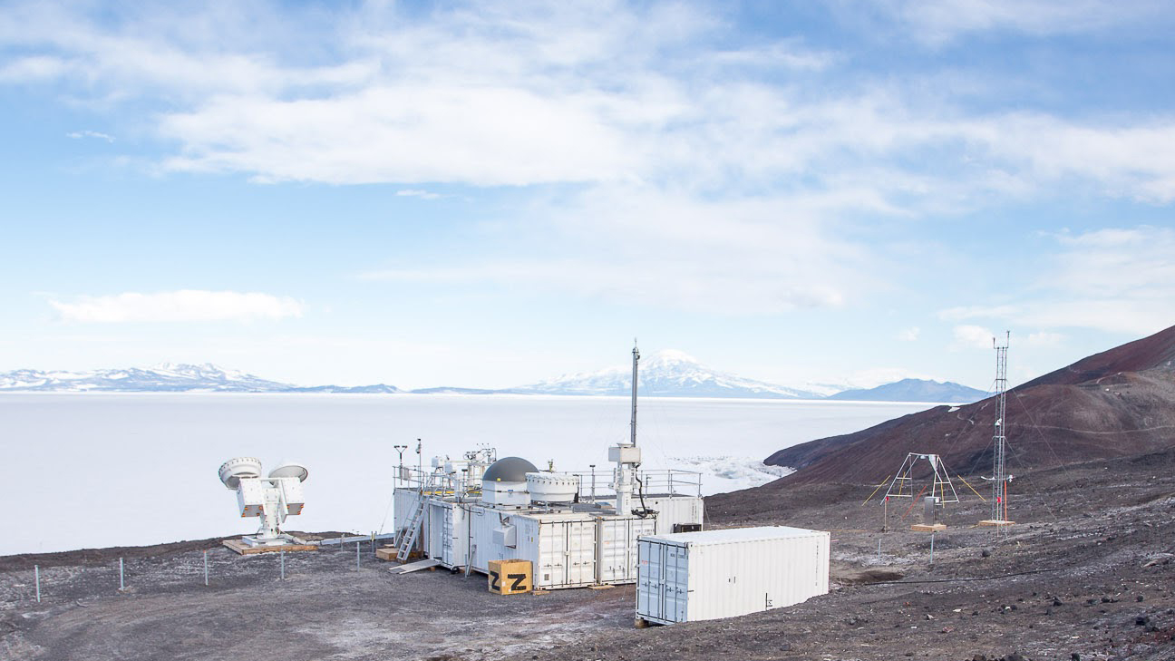
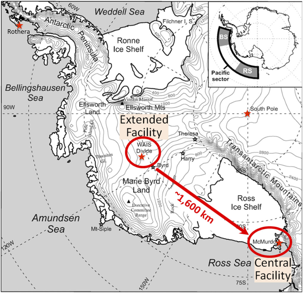
ARM set up a mobile observatory on a flat seaside site less than a mile from McMurdo Station. McMurdo is the main research hub of the U.S. Antarctic Program, maintained by the National Science Foundation. A secondary ARM instrument site was installed at the WAIS Divide Ice Camp, about 1,000 miles to the northwest.
AWARE marked the first time since 1967 that detailed measurements of atmospheric physics had been made in West Antarctica.
Scientists worldwide can freely access AWARE data in the ARM Data Center.
Getting Rare Measurements
In total from the two sites, AWARE ran from November 2015 to January 2017. The campaign was an attempt to broaden observational data on the continent, including measurements of the dynamical atmospheric conditions that might prompt warming. Several decades of satellite imagery and meteorological analysis indicate that West Antarctica is vulnerable to warm marine air and cloud cover from nearby seas: the Amundsen, Ross, and Bellingshausen.
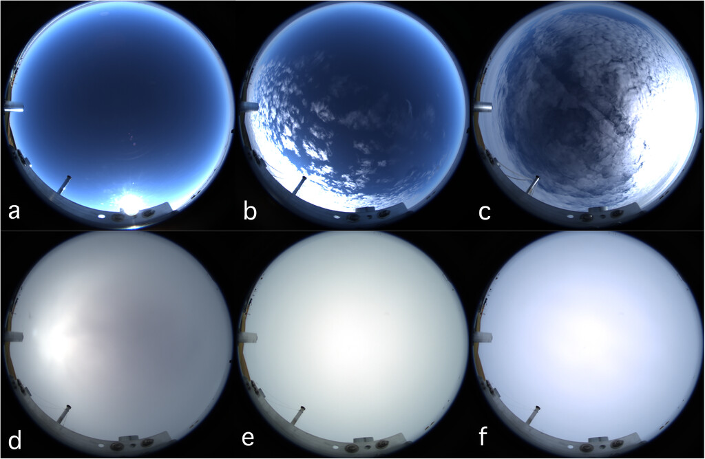
Yet given Antarctica’s extremes of cold and wind, such measurements are sparse and hard to get. In particular, accurate data on surface energy fluxes and related cloud properties are difficult to come by. Low-level clouds over Antarctica and the surrounding Southern Ocean remain a major source of uncertainty in global climate models.
Antarctica is home to at least 50 all-season, long-term international research stations, “all of them doing excellent, first-order work,” says Lubin, a climate sciences researcher from Scripps Institution of Oceanography at the University of California San Diego. But if you were to sum up their instrumentation, he adds, “All of them together would not equal one AWARE, (which) provided a combination of instruments that was very unique.”
Lubin gave the example of combining three radar frequencies to get at cloud microphysics. He also highlighted the ability to get rare data on the antarctic surface and cloud properties that influence incoming solar radiation.
Those rare data included measurements of aerosols, the tiny atmospheric particles that make clouds and precipitation possible.
Aerosol researcher Lynn Russell, a professor of climate sciences at Scripps, co-led the AWARE campaign with Lubin. Russell says that AWARE collected the only yearlong data set on aerosol chemical composition, “as far as I know, at any location in Antarctica.”
AWARE’s Dual Sites
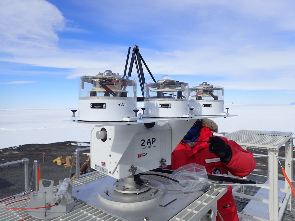
AWARE deployed “an unprecedented, comprehensive suite of ground-based in situ and passive and active remote sensing instruments,” says Israel Silber, an earth scientist at Pacific Northwest National Laboratory in Washington state. He called the AWARE deployment “a great achievement.”
ARM’s mobile observatory at McMurdo Station included cloud radars, high-spectral-resolution lidar, and a suite of aerosol instruments. A team from Los Alamos National Laboratory in New Mexico and the Australian Bureau of Meteorology set up the observatory.
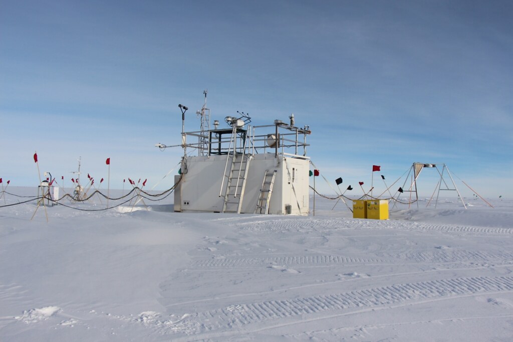
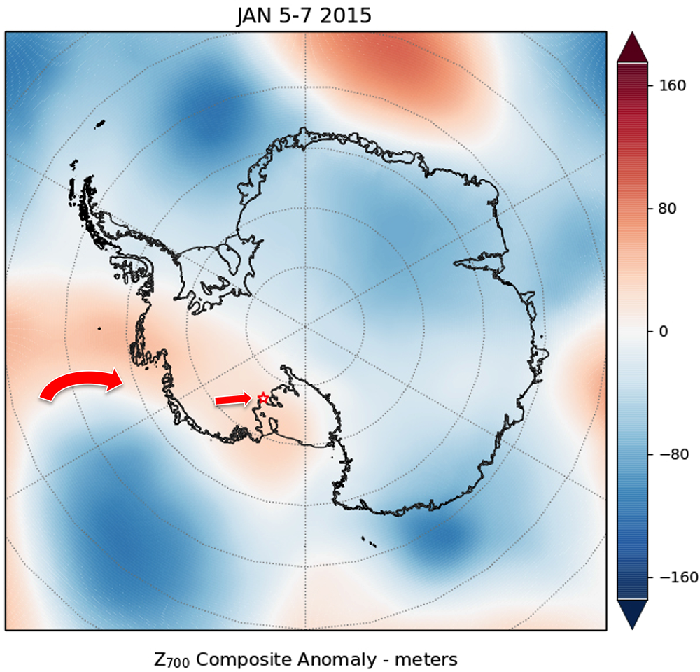
ARM’s secondary instrument site at the WAIS Divide Ice Camp operated for about six weeks during Antarctica’s summer of 2015–2016. Researchers there got to observe a significant ice melt event, described in a 2017 paper in Nature Communications.
AWARE’s radiation observations in the upper air, in clouds, and at the surface provided valuable context for the 15-day melt event.
Valuable Antarctic Data
Almost a decade later, the AWARE campaign is worth looking back at for its trove of atmospheric data from the world’s southernmost continent.
AWARE is also worth a glance after eight years because of its copious contribution to antarctic research literature, including 44 journal articles and nine technical reports as of February 2024.
“Antarctica is a very unique environment, which requires continual study in its own right,” apart from the more widely studied Arctic, says Lubin.
AWARE data consider variations in cloud microphysics and El Niño storm tracks that influence ice shelf warming and melting.
That said, adds Silber, “Our observational knowledge is still deficient over the polar regions in general, especially over Antarctica.”
Polar-orbiting satellites help, he adds, but their samples of Earth’s high latitudes are limited—and create data that are challenging to interpret. For one, analyzing surfaces covered by ice and subject to extreme cold is difficult, especially in nighttime darkness.
The limitations of satellite data make local ground measurements a valuable way to “observe, characterize, and study this region,” says Silber, and “to gain essential process understanding that could have been otherwise overlooked.”
An AWARE ‘Sequel’
Lubin led an October 2023 paper that used cloud and radiation data from a suite of new portable instruments deployed in Antarctica. The instruments operated on a 60-square-mile ice cap called Siple Dome.
Lubin describes the 2019–2020 experiment as a “sequel” to AWARE.
“We took the energy balance instruments from AWARE and a spectroradiometer for cloud physics,” along with an ALCOR System camera to surveil the sky, says Lubin. “Then we miniaturized them and made them transportable. In principle, we can go to many, many remote locations. The experiment was successful and a good proof of concept.”
Hardy and autonomous field instruments, which Lubin sees as the future, address the plainest fact about Antarctica—that it is a place of extremes. It is more cold, dry, and windy than anywhere else on Earth.
The work at Siple Dome illustrates a thread that runs through many of the most recent AWARE-related papers: that one way to dodge measurement difficulties in Antarctica is to develop a new generation of simple, inexpensive, and robust instruments that are automated.
Lubin and his co-authors show that their instruments, field-hardened and with renewable energy sources, can provide measurements that will help scientists evaluate climate model simulations.
The Utility of AWARE Instruments
The theme of small, rugged instruments also appears in an August 2023 study led by onetime University of California San Diego master’s student Kristopher Scarci.
Lubin was one of Scarci’s co-authors. Their paper explores the use of what they call “basic and relatively low-cost broadband and filter radiometers.” According to the authors, such instruments can measure how even small climate changes influence cloud microphysics.
The radiometers, whose data can reveal the presence of liquid water or ice in clouds, were part of AWARE’s main instrument site on Ross Island in McMurdo Sound.
Other recent AWARE-related papers include a pair of connected studies on blowing snow at McMurdo Station. Their authors were University of Manitoba PhD student Nicole Loeb and University of North Dakota snow researcher Aaron Kennedy.
Blowing snow affects the distribution of atmospheric aerosols and influences processes that cool and moisten the boundary layer over Antarctica. It also has an impact on the mass balance of ice sheets that is not reflected in current climate models.
Both papers by Loeb and Kennedy illustrate the durable utility of AWARE data.
In their first paper, Loeb and Kennedy estimated that blowing snow at McMurdo occurred 7.4% of the time during AWARE. The March 2021 study relied on surface and remote sensing (ceilometer) observations from the campaign. It also used an updated algorithm for detection of blowing snow.
Loeb and Kennedy’s second paper came out in December 2022. The authors used AWARE radar reflectivity observations, micropulse lidar backscatter data, and ceilometer measurements to inform an algorithm for estimating snow depth. The algorithm estimated an average depth of 168.2 meters (about 550 feet).
Ice-Melt Dynamics
Scripps alum Madison Ghiz led a July 2021 paper that drew on AWARE data. Lubin calls the paper “a very nice analysis of the various mechanisms by which the atmosphere can induce surface melt in Antarctica.”
The researchers analyzed case studies from the Thwaites and Pine Island glaciers, which are close to each other in West Antarctica. They also used data from Siple Dome, where fieldwork is easier to perform.
Glaciers are slabs of ice and rock that start on land and edge downward, eased ahead by weight and gravity. The Thwaites Glacier, about the size of Wisconsin, is gradually nosing into the sea, where its meltwater contributes about 4% of global sea level rise. That said, recent research shows that gigantic jags of rock under the glacier are slowing its progress to the sea.
With Lubin among her co-authors, Ghiz demonstrated three main mechanisms of ice melt in West Antarctica:
- longwave heating by cloud cover that is optically thick, which like a thermal blanket would concentrate solar energy onto the ice
- enhanced radiation, from all wavelengths, in the presence of optically thin clouds
- föhn winds, warm downslope mountain winds that can spike ambient temperatures in a matter of hours.
Polar Modelers
The Ghiz et al. contribution to AWARE literature reminded Lubin of Silber’s extensive modeling work on the contribution of polar clouds to surface warming in Antarctica. Silber often works with Ann Fridlind, a climate modeler at NASA’s Goddard Institute of Space Studies in New York.
Since 2019, Silber and Fridlind have led or co-authored more than 15 peer-reviewed papers using AWARE data—often supplemented by contextual cloud and aerosol measurements from satellite platforms.
In one study from 2019, Silber, Fridlind, and other scientists used a range of AWARE observations to evaluate downwelling longwave radiation biases in two widely used forecast and reanalysis models.
Longwave radiation, emitted from the Earth’s surface, is partially re-radiated back to the surface by water particles in the atmosphere. That means the distribution of clouds, for example, strongly affects atmospheric heating and cooling calculations.
Drizzle and Other Polar Puzzles
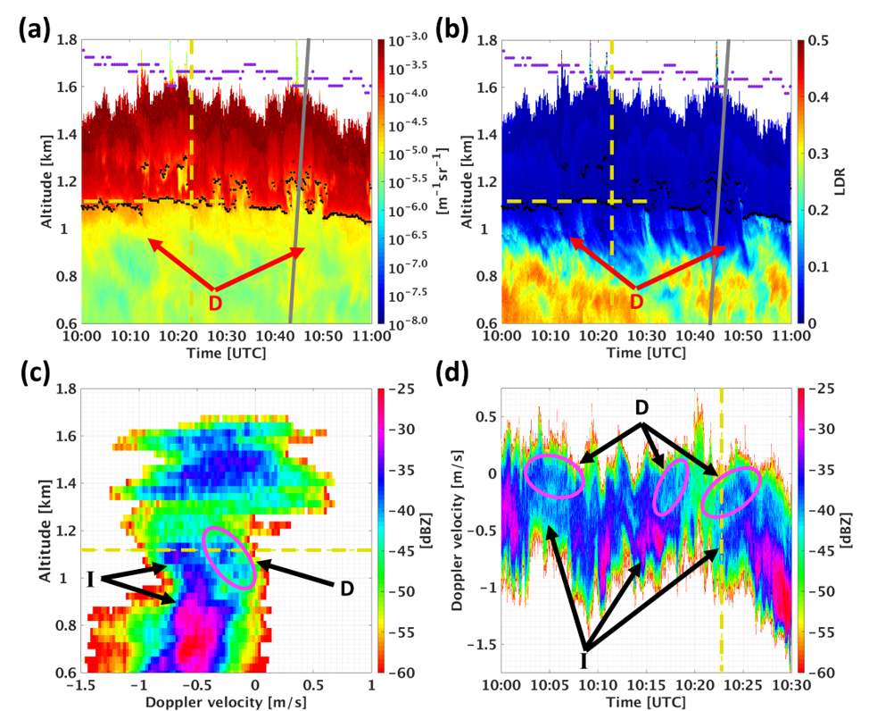
Another Silber-Fridlind study from 2019 shed light on a rarely reported phenomenon in the Earth’s high latitudes: the occurrence of drizzle when cloud temperatures are below minus 20 degrees Celsius (minus 4 degrees Fahrenheit). Normally, drizzle is not thought to persist in very cold environments.
The paper focused on a 2016 drizzle event at McMurdo Station that lasted for more than seven hours and occurred when cloud temperatures were minus 25 degrees Celsius (minus 13 degrees Fahrenheit) or colder. The drizzle may have been part of a moving cloud field that stretched more than 1,000 kilometers (about 620 miles) along the Ross Ice Shelf coast.
In addition to using AWARE measurements, the two modelers used satellite data from a 2006–2023 joint U.S.-French mission called Cloud-Aerosol LIDAR and Infrared Pathfinder Satellite Observations (CALIPSO). The purpose of CALIPSO was to measure impacts of clouds and aerosols on the Earth’s climate and, in turn, inform three-dimensional models of the atmosphere.
The Silber-Fridlind simulations indicated that drizzle at those temperatures may contribute more water than ice. The work also showed that cold-cloud drizzle is likely common in the low-aerosol conditions of Antarctica and the Southern Ocean.
Such studies “could not be developed without extensive use of the full unprecedented active remote sensing instrument suite at AWARE,” says Silber.
He adds more examples of modeling work boosted by AWARE—in each case with partial funding from DOE’s Atmospheric System Research (ASR) program:
- an evaluation of the Community Atmosphere Model version 6 (CAM6) using AWARE cloud observations
- a study evaluating high-latitude clouds simulated by the atmospheric model in version 2 of DOE’s Energy Exascale Earth System Model (E3SM)
- the evaluation of summer cloud microphysics simulated by the Polar Weather Research and Forecasting Model (WRF) and the Antarctic Mesoscale Prediction System (AMPS)
Other modeling studies that rely on AWARE data are currently under review, says Silber. “So, eight years after, we still see the fruits.”
Complementary Campaigns
AWARE data could soon pair with measurements from other coastal campaigns.
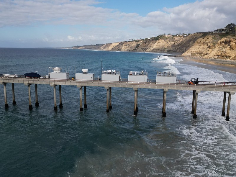
With Lubin and Silber as co-investigators, Russell led ARM’s 2023–2024 Eastern Pacific Cloud Aerosol Precipitation Experiment (EPCAPE).
ARM deployed instruments for EPCAPE in La Jolla, California, on a pier and at a mountain site overlooking the Pacific Ocean. The multi-institutional, international field campaign wrapped up in mid-February 2024.
Russell notes similarities between the EPCAPE and AWARE locations.
“They’re both coastal sites affected by clouds and cooled by clouds,” says Russell. “In both, as the clouds change, the climate changes. Understanding the cloud cover at both sites is super important.”
Another ARM campaign could have scientific crossover with AWARE.
From April 2024 to September 2025 in northwestern Tasmania, the Cloud And Precipitation Experiment at kennaook (CAPE-k) will use components of the same ARM mobile observatory deployed for AWARE.
Led by professors Gerald “Jay” Mace of the University of Utah and Roger Marchand of the University of Washington, CAPE-k will study largely pristine air masses coming in from the Southern Ocean.
CAPE-k will be ARM’s first Southern Ocean campaign since it finished conducting a pair of studies in the region in 2018.
Lubin likes the timing and location of CAPE-k. In 2025, on the other side of the Southern Ocean, he will lead a group of researchers setting up instruments at Palmer Station in northwestern Antarctica.
Interested in AWARE data? Check out past data announcements, and go to the ARM Data Center.
With funds from the National Science Foundation’s Office of Polar Programs, Lubin will set in motion a study called Antarctic Low Cloud Interaction with Natural Aerosol (ALCINA). The 18-month study is intended to have an AWARE-like duration of continuous measurements.
To reduce errors in climate simulations of Antarctica and the Southern Ocean, ALCINA will measure aerosol chemistry and microphysical properties, as well as cloud optical properties. Samples will come from continental and marine sources.
AWARE, EPCAPE, CAPE-k, and ALCINA all represent opportunities for collaboration and data-sharing as scientists take “one step at a time” in understanding cloud microphysics, says Lubin. “You learn to crawl before you walk.”
Follow Us:


Keep up with the Atmospheric Observer
Updates on ARM news, events, and opportunities delivered to your inbox
ARM User Profile
ARM welcomes users from all institutions and nations. A free ARM user account is needed to access ARM data.


