

ARM Collaborations Aim to Solve Mysteries of Southern Ocean Clouds
Published: 20 May 2018
MARCUS, MICRE field campaigns are part of effort to understand Earth system processes in region
The Southern Ocean is one of the most remote—and stormiest—places on Earth. It also has significant influence over the planet’s oceanic and atmospheric circulation.
However, earth system models struggle to accurately simulate clouds, aerosols (tiny particles in the air), and precipitation in the region. In particular, they have difficulty capturing supercooled liquid clouds, which remain composed of liquid droplets rather than ice even though the temperature in the clouds is below freezing. Models also tend to underestimate sunlight reflected by near-surface clouds. These modeling challenges are linked to poor understanding of cloud and aerosol properties over the Southern Ocean.
Two recent field campaigns coordinated by the Atmospheric Radiation Measurement (ARM) Climate Research Facility, a U.S. Department of Energy scientific user facility, are helping to shed light on these properties.
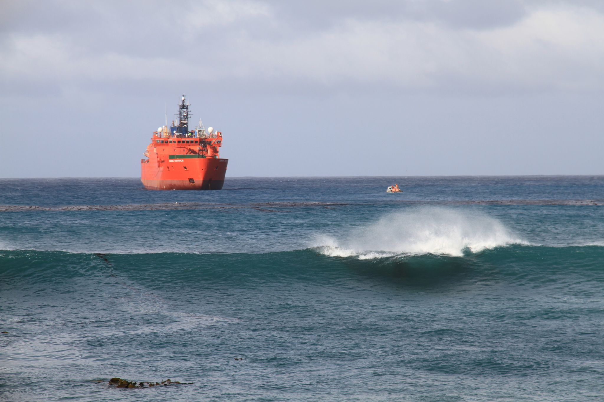
The Measurements of Aerosols, Radiation, and Clouds over the Southern Ocean (MARCUS) field campaign took an ARM mobile facility on four voyages aboard the Australian Antarctic supply vessel Aurora Australis from October 2017 to April 2018. Meanwhile, the two-year Macquarie Island Cloud and Radiation Experiment (MICRE), a ground-based deployment that wrapped up in March 2018, provides a longer set of observations over a complete seasonal cycle.
MARCUS and MICRE, both collaborations between the ARM Facility, Australian Antarctic Division, and Australian Bureau of Meteorology, are part of a larger international, multi-agency effort that seeks to expand understanding of clouds, aerosols, radiation, precipitation, air-sea exchanges, and their interactions over the Southern Ocean.
Remote Island Research
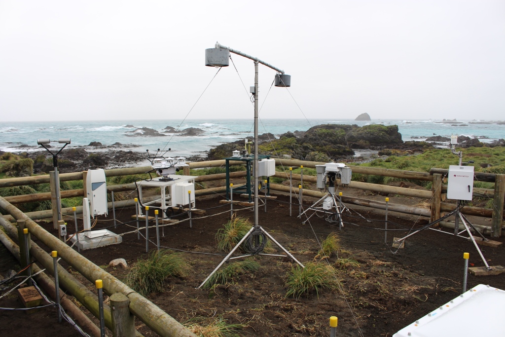
The MICRE team is checking the accuracy of satellite data against observations at Macquarie Island, which is located between New Zealand, Australia, and Antarctica.
“Analysis using satellite data suggests that models are having difficulty in correctly calculating the amount of sunlight reaching the surface at high southern latitudes, and this is largely due to clouds,” says Roger Marchand, MICRE’s principal investigator and a research associate professor of atmospheric sciences at the University of Washington. “But there’s some concern about how good the satellite data are over the Southern Ocean. These data have really not been tested in this area and were designed based primarily on Northern Hemisphere observations.”
So far, in comparing surface radiative fluxes observed during MICRE with satellite-based estimates, shortwave estimates are doing well while longwave data are coming up short.
“We’re still trying to understand what’s driving those differences,” says Marchand, whose team also plans to evaluate precipitation, aerosol, and cloud properties—not just their effect on radiative fluxes.
MICRE collected data over a two-year period—much longer than can typically be done with ship or aircraft campaigns—with a goal of studying seasonal and diurnal variability. ARM Facility instruments used in MICRE included:
- microwave radiometers (measuring water vapor and cloud liquid water)
- passive radiative flux instruments
- a laser ceilometer (measuring cloud-base height and backscattered radiation)
- a sunphotometer (measuring direct solar irradiance and sky radiance at the surface)
- a multifilter rotating shadowband radiometer (measuring aerosol optical depth)
- a disdrometer (measuring precipitation).
The ARM instrument data will be used in combination with Australian cloud radar and lidar observations, as well as other surface measurements.
Anticipating instrument issues because of the salty marine air, the MICRE team also sent along spare parts for the hardware expected to be the most problematic on the remote island. On-site technicians made some repairs when instruments went down, but sometimes replacement instrumentation had to be sent on the next resupply mission. It was often a long wait—Macquarie Island is resupplied from Australia twice a year.
“We knew it was a harsh environment, and we planned as best as we could for some possible failures,” says Marchand. “This was helpful in maximizing our operational time, but nonetheless we do have some significant gaps in some of the instrument datastreams. On the good side, we have at least a year of data from all of the major instruments.”
Science at Sea
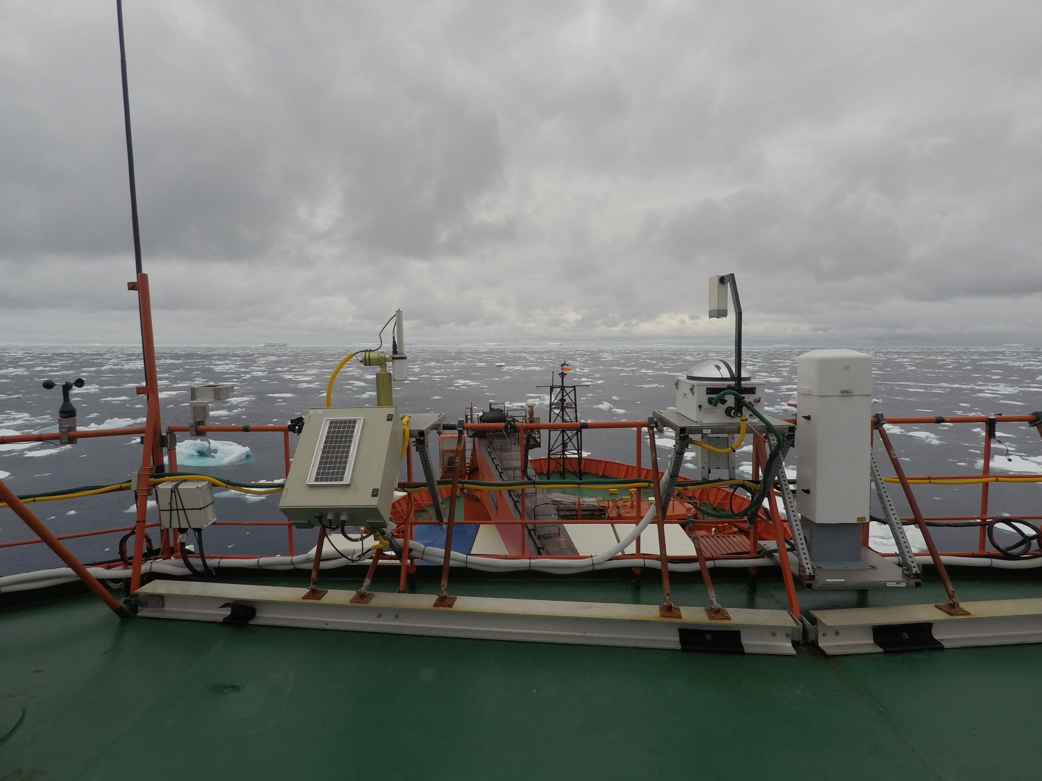
MARCUS, which obtained key atmospheric data via the second ARM Mobile Facility (AMF2) deployed on the Aurora Australis, can claim a Southern Ocean research milestone.
As the supply vessel traveled from Hobart, Australia, to Australian Antarctic research stations Mawson, Casey, and Davis, and to Macquarie Island, shipborne instruments gathered continuous measurements that captured the properties of clouds and aerosols north and south of the oceanic polar front (typically around 60 degrees south) in spring, summer, and autumn.
“It’s really the first set of comprehensive data that describe the seasonal properties of clouds and aerosols south of the oceanic polar front,” says Greg McFarquhar, the campaign’s principal investigator. “It’s been really unique seeing how pristine the clouds are. There seems to be lots of supercooled water in them, and we just need to do a better job of quantifying that.”
Full quality-controlled data should be available by fall 2018, and production of ARM value-added products (higher-order data products) is also underway. In the meantime, preliminary data analysis has focused on how cloud properties vary with meteorological conditions and aerosol amounts.
“We’re seeing some of the dependence of the cloud properties on the lower atmospheric stability,” says McFarquhar, director of the Cooperative Institute for Mesoscale Meteorological Studies and a professor in the School of Meteorology at the University of Oklahoma. “We’re going to look at how they depend on the air mass origin, wind speed and direction, sea surface temperature, whether we’re north or south of the oceanic polar front, and the location of the observations within the cyclone.”
Despite rough waves and frequent encounters with sea spray, the instruments were quite resilient. This feat resulted from the work of ARM staff members at Los Alamos National Laboratory and ARM instrument mentors from multiple institutions who hardened the instruments for some of the worst conditions on the planet.
MARCUS required up to 12 ARM staff to install instruments on the Aurora Australis and up to eight while uninstalling. There were three technicians on each voyage, overseeing the instruments and conducting about 600 radiosonde (weather balloon) launches during the field campaign.
“Never will you be able to get 100 percent when you’re working in an environment like that, but overall, everything worked exceedingly well apart from just a couple of small failures,” says McFarquhar. “That I would say is probably the most significant accomplishment to come out of this to date.”
Working in Harmony
The rest of 2018 is shaping up to be monumental for the Southern Ocean research effort.
In July, presentations using MARCUS data will take place during the 15th Conference on Cloud Physics, hosted by the American Meteorological Society in Vancouver, Canada.
At the American Geophysical Union’s 2018 Fall Meeting in December in Washington D.C., a special session of Southern Ocean clouds and aerosols will feature results from MARCUS, MICRE, and other recent campaigns in the region.
“All of the data sets are very complementary to each other,” says McFarquhar. “You get a lot of synergy by using the data sets together.”
Investigators hope these results will eventually help improve the accuracy of earth system models. Already, some sounding data have been incorporated into the Australian Community Climate and Earth-System Simulator (ACCESS), an Australian Bureau of Meteorology model that produces Southern Ocean forecasts. Large-eddy simulation modeling runs are also being explored.
“It’s really exciting after all these years of planning to finally see the data coming available, coming online,” says McFarquhar, “and beginning to see some of the stuff that we can do with it.”
The ARM Climate Research Facility is a DOE Office of Science user facility. The ARM Facility is operated by nine DOE national laboratories.
Follow Us:


Keep up with the Atmospheric Observer
Updates on ARM news, events, and opportunities delivered to your inbox
ARM User Profile
ARM welcomes users from all institutions and nations. A free ARM user account is needed to access ARM data.


