

ARM Begins Making Moves to Balance Scope and Resources in FY2024
Published: 27 October 2023
Aim is to meet user needs and ensure continued delivery of impactful data
Changes have started coming to the Atmospheric Radiation Measurement (ARM) user facility in fiscal year 2024.
ARM is making site enhancements while retiring some instruments and relocating others. The user facility is also reducing the footprint of its Southern Great Plains (SGP) atmospheric observatory.
These changes are intended to meet needs of the science community within existing constraints, and they address recommendations from the 2020 Triennial Review and goals of the ARM Decadal Vision. ARM is also responding to feedback from users and making important additions to meet their stated needs. These needs include the expansion of spatial sampling to better link ARM sites to models and filling gaps in aerosol measurements.
Budget considerations are also driving a lot of the changes within ARM. Enhancements come with a cost, says ARM Director Jim Mather, and there have been significant unexpected costs across several projects.
Following a significant budget increase in 2022, ARM saw a decrease in 2023 and is expecting a decrease in 2024. With a flat budget or decrease, ARM needs to look at how it balances new scope and its resources, namely staff, time, and money.
In addition, inflation has driven up overall costs. “That put us in a situation where we really needed to make some decisions now,” says Mather.
“There’s virtually no measurement that we’re making that we wouldn’t prefer to simply keep making because all measurements have value, but we have seen that some measurements are having a significantly greater science impact than others, and we just don’t have the resources to keep doing everything.”
Spatial Measurements
Over a number of years, users have asked ARM to expand its measurements in certain ways. One of those ways is through better spatial sampling—a topic that ARM takes on in its Decadal Vision and is important for linking ARM sites to larger scales and to models. This has been happening at the SGP much more than at other ARM sites, says Mather.
ARM Mobile Facilities (AMF) have not always had that capability, but in recent years, scientists have relied on supplemental sites to provide spatial context for AMF measurements. During the 2021–2022 TRacking Aerosol Convection interactions ExpeRiment (TRACER), ARM operated a group of supplemental sites in addition to an AMF in the Houston, Texas, area.
Like TRACER, the Coast-Rural-Urban Atmospheric Gradient Experiment (CoURAGE), a 2024–2025 ARM field campaign in and around Baltimore, Maryland, will have ancillary sites to study the heterogeneous environment. ARM’s forthcoming Bankhead National Forest (BNF) observatory in northern Alabama will have three supplemental sites and two radar sites. In addition, supplemental sites will be a part of the next AMF call, coming later in 2023.
All of this means some changes for the SGP, ARM’s oldest observatory.
“We’re trying to make spatial measurements more typical of the ARM sites and make the SGP more consistent with that general model for overall sustainability,” says Mather.
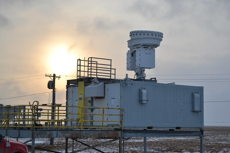
SGP Reconfiguration
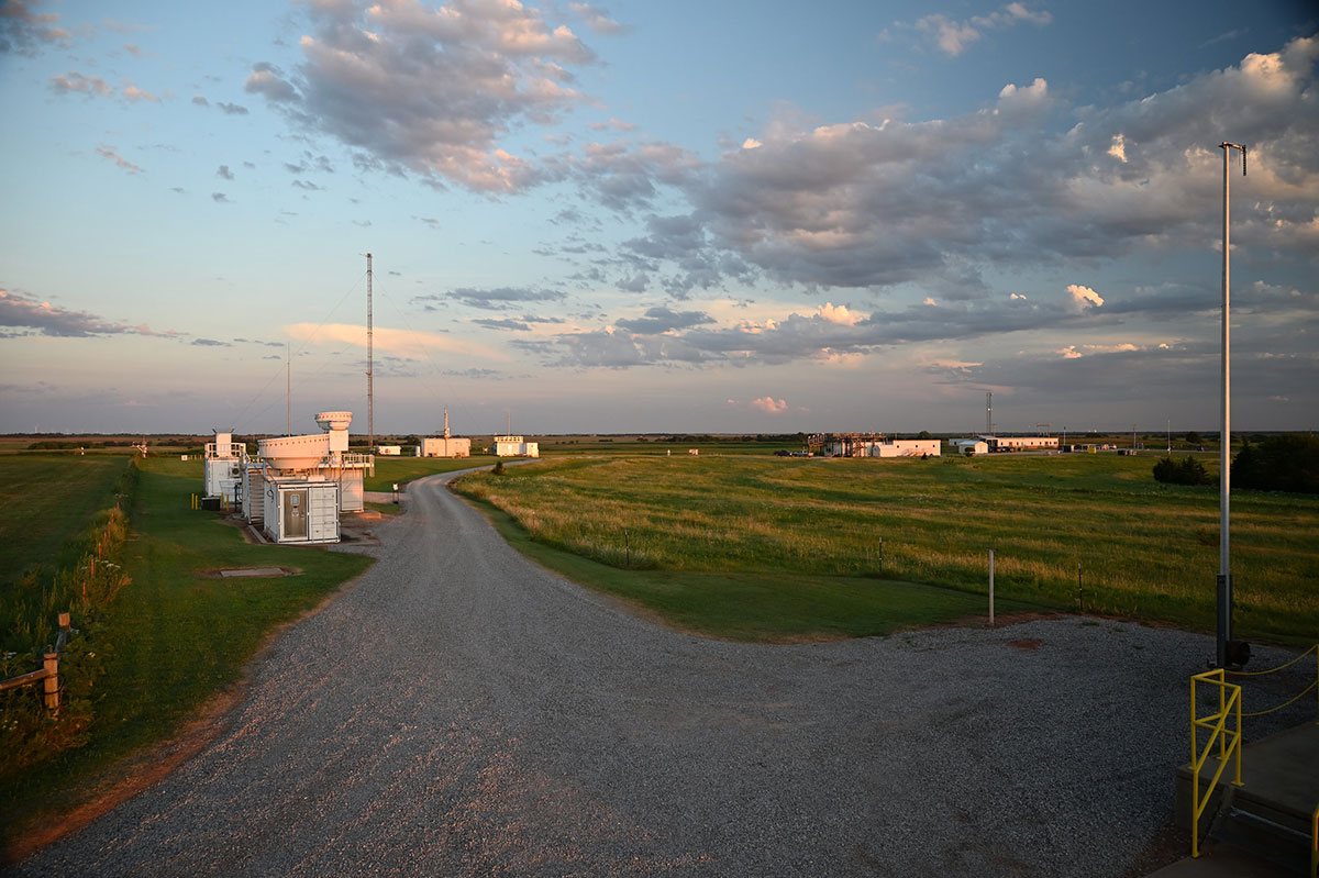
The SGP is the ARM site with the most diverse capabilities. It is also ARM’s most prolific site in terms of publications produced each year.
ARM put an array of extended facilities at the SGP to sample spatial variability, but facility management found that these measurements are used less than the core facility, and some of the measurements are seeing very little use.
To generate savings that offset extra costs at other sites, ARM has begun ceasing operations of some SGP extended (E) and intermediate (I) facilities. This move will also create more uniform treatment and consistency between the SGP and BNF.
The changes will reduce the SGP’s footprint from about 9,000 square miles to roughly 3,000 square miles.
“By engaging with the modeling community, we believe we can continue to support the integration of modeling with SGP observations with a smaller set of sites,” says Mather.
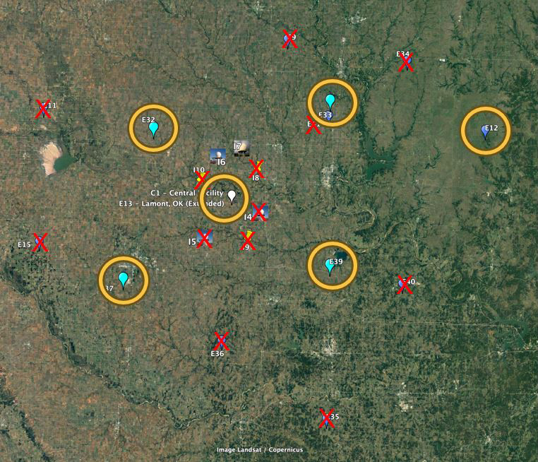
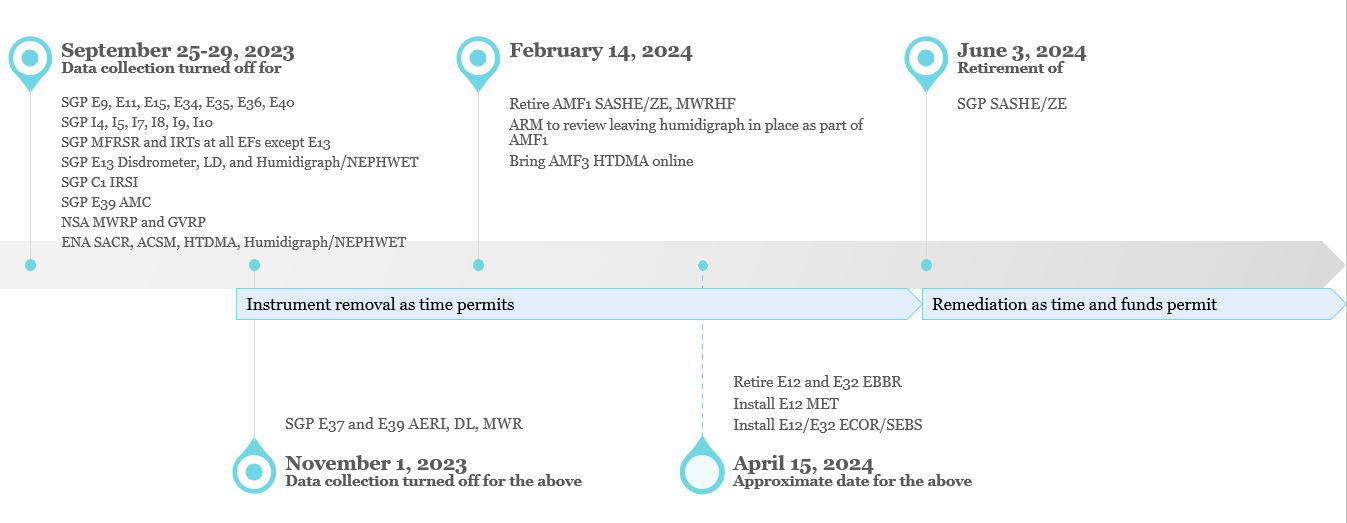
At the end of September 2023, ARM shut off data collection at the following sites:
- E9 (Ashton, Kansas)
- E11 (Byron, Oklahoma)
- E15 (Ringwood, Oklahoma)
- E34 (Maple City, Kansas)
- E35 (Tryon, Oklahoma)
- E36 (Marshall, Oklahoma)
- E40 (Pawnee, Oklahoma)
- X-Band Scanning ARM Precipitation Radar (XSAPR) sites I4 (Billings, Oklahoma) and I5 (Garber, Oklahoma)
- C-Band Scanning ARM Precipitation Radar (CSAPR) site I7 (Nardin, Oklahoma)
- radar wind profiler (RWP) sites I8 (Tonkawa, Oklahoma); I9 (Billings); and I10 (Lamont, Oklahoma).
ARM is retaining the I7 site for future use of its deployable C-band radar. It is also keeping the I6 site (Deer Creek, Oklahoma), which has an XSAPR.
In addition to E13, which is co-located with the SGP Central Facility near Lamont, ARM plans to retain five other extended facilities:
- E12 (Pawhuska, Oklahoma)
- E32 (Medford, Oklahoma)
- E33 (Newkirk, Oklahoma)
- E37 (Waukomis, Oklahoma)
- E39 (Morrison, Oklahoma).
E12 is unique from other SGP extended facilities in that it is located in native prairie grass. ARM sited most of its extended facilities on cultivated land.
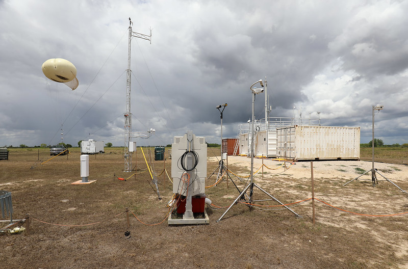
E32, E33, E37, and E39 were used for the Large-Eddy Simulation (LES) ARM Symbiotic Simulation and Observation (LASSO) activity, which produced data bundles of shallow convection for five seasons (2015–2019). While the extended facilities will remain, ARM plans to turn off the atmospheric emitted radiance interferometers (AERIs), Doppler lidars (DLs), and microwave radiometers (MWRs) at E37 and E39 by the beginning of November 2023. These instruments have already been removed from E32 and E41 (Peckham, Oklahoma) in support of the American WAKE experimeNt (AWAKEN) and will be used for the BNF.
“We are making a concession in taking away extended instruments from the boundary-layer profiling sites, which were by far the most used, but they were specifically put there to support LASSO,” says Mather.
“We’re reducing the scope that we’ve had at SGP, but it will continue to be the ARM testbed, with an extensive guest facility, calibration facility, and an extensively instrumented Central Facility, so we expect it to continue to be very productive.”
ARM Director Jim Mather
The boundary-layer profiling capability will be available at the BNF, which is expected to run at least five years. It is possible that the capability could return to the SGP in the future, but “it’s an intensive activity that can’t be sustained long term at multiple sites,” says Mather.
Across the SGP, ARM is retiring the energy balance Bowen ratio (EBBR) system to streamline operations with one flux system—the eddy correlation flux measurement (ECOR) system. The ECOR/surface energy balance system (SEBS) will be installed at E12 and E32.
A surface meteorology (MET) system will also be installed at E12, and ARM will remove the AmeriFlux Measurement Component (AMC) system at E39 to move toward having a consistent footprint across the extended facilities, says ARM Instrument Operations Manager Adam Theisen.
ARM will continue to support the AmeriFlux network, which measures ecosystem carbon, water, and energy fluxes in the Americas. ARM still has an AMC at its North Slope of Alaska (NSA) observatory.
Though ARM will no longer be in Kansas with the removal of E9 and E34, the data for all removed sites will remain freely available in the ARM Data Center.
Data from retired/removed instruments will also stay available.
“We’re reducing the scope that we’ve had at SGP, but it will continue to be the ARM testbed, with an extensive guest facility, calibration facility, and an extensively instrumented Central Facility, so we expect it to continue to be very productive,” says Mather.
Radar and Aerosol Operations
Radars and aerosol instruments combine for the largest part of ARM instrument operations, which means they require a lot of resources.
ARM recently published its FY2024 aerosol operations plan. The user facility’s FY2024 radar plan will soon be published.
“We’re trying to achieve a sustainable set of measurements that maximize science impact,” says Mather.
The plans should help ARM get closer to achieving balance in the two areas.
For the radar plan, ARM is taking into account user feedback on its radar operations. ARM obtained this feedback during a set of 2022 listening sessions. Those sessions indicated significant value in operating a single precipitation radar at the SGP, but the impact of running multiple radars at the same time diminished after that. That factored into the decision to end most SGP precipitation radar operations. However, when discussing the value of radar pairs, session participants strongly favored having both an X- and a C-band radar, so ARM is keeping the I6 XSAPR and I7 infrastructure to provide the ability to deploy a C-band system for intensive operational periods or field campaigns in the future.
At the NSA, ARM will reduce or defer support for a few radars in FY2024. The NSA’s scanning ARM cloud radar (SACR) will not operate this fiscal year because of needed repairs. Based on the listening sessions, the SACR is expected to be of high importance because of its potential for supporting mixed-phase cloud studies, so ARM will work this year on bringing it back to full health with the hope of returning it to service in FY2025.
Meanwhile, ARM is looking at what it can support at the Eastern North Atlantic (ENA) observatory, located in the Azores archipelago west of mainland Portugal.
“The ENA is a challenging site to operate scanning radars long term,” says Mather.
The ENA SACR will not operate in FY2024, and there are no immediate plans for that system. ARM will explore mechanisms to support an ENA X-band radar to capture the state of drizzle, which is a high measurement priority for users. The XSAPR is expected to be the observatory’s most valuable scanning radar because it provides an opportunity to observe the spatial occurrence of drizzle, a critical observation at the ENA.
In its aerosol plan, ARM lists its progress in addressing recommendations from the Aerosol Measurement Science Group (AMSG), which consists of experts across ARM and the atmospheric science community. The AMSG provides input to Mather to improve the operational performance, characterization, and science impact of ARM’s aerosol and trace gas measurements along with the development, processing, and delivery of aerosol data products.
A recommendation for ARM to add aerosol measurements at the NSA came out of the first AMSG workshop in 2017. ARM will now be implementing those measurements.
Meanwhile, a new aerosol calibration facility will address user requests for more comprehensive calibration standards and transparency. The facility will be located at Brookhaven National Laboratory in New York, where most of ARM’s aerosol instrument mentors work.
To offset these new aerosol measurement capabilities, ARM has begun making changes to other areas of its aerosol instrument operations.
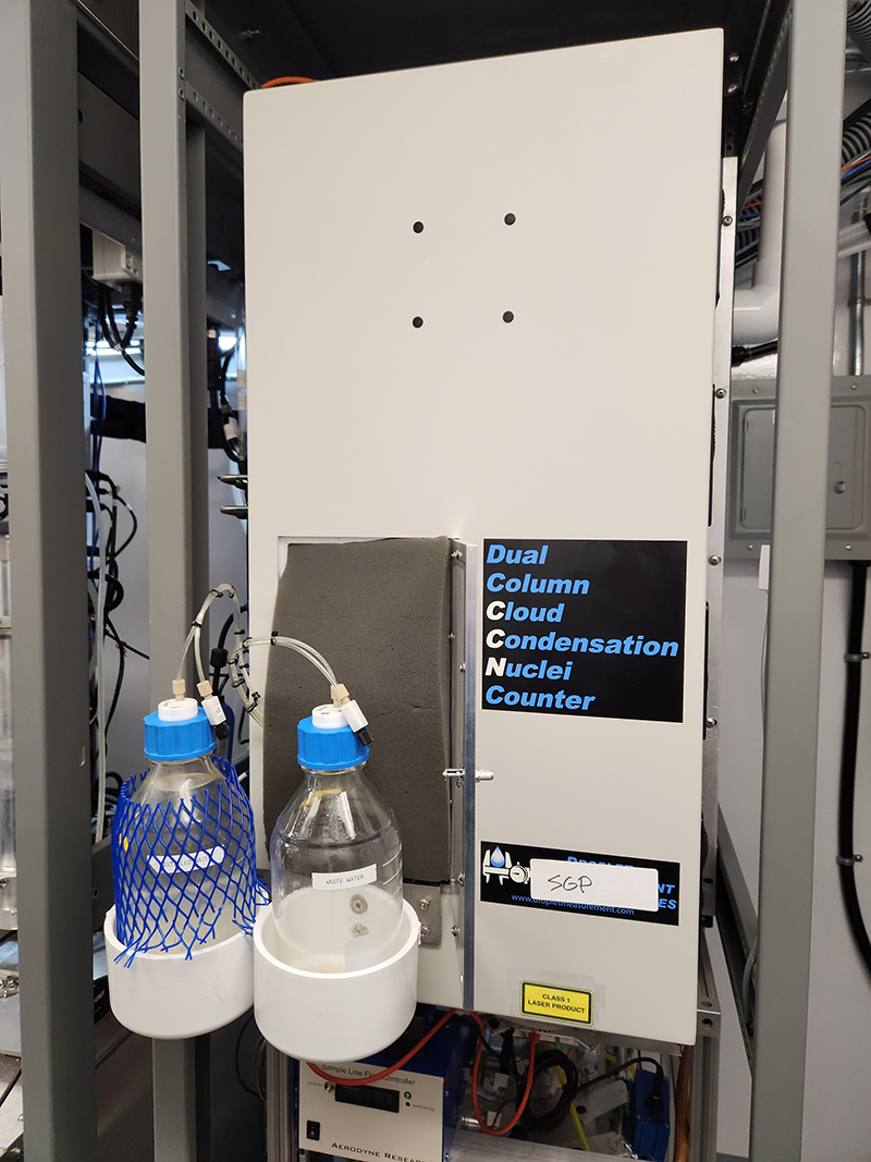
The most significant aerosol measurement changes are coming in the area of hygroscopicity—the ability of particles to take up moisture from the environment. ARM is currently making measurements related to hygroscopicity through the cloud condensation nuclei counter (CCN), humidigraph, and humidified tandem differential mobility analyzer (HTDMA). In the near term, ARM will emphasize CCN measurements, shift to episodic HTDMA operations, and cease humidigraph operations.
ARM is also taking one aerosol chemical speciation monitor (ACSM) offline to maintain the current number of operational instruments of that type. Operating an ACSM is a high priority at the NSA, but ARM currently cannot operate this instrument at all sites, so the ENA ACSM is now offline. The ACSM is one of ARM’s more difficult instruments in terms of data complexity and cost, says Mather.
Other Instrument Operations
One of the recommendations to come out of the 2020 Triennial Review was for ARM to evaluate its capabilities and sunset those that are less impactful.
An ARM team completed an evaluation of instruments based on the following metrics:
- data downloads (usage)
- impact (publications)
- sustainability
- cost/uptime.
“We don’t want to be collecting data that we can’t support,” says Mather. “We don’t want to have commitments to instruments that we can’t reasonably maintain.”
During the evaluation process, the ARM review team found that some measurements were being used less than others and/or were less central to the user facility’s core mission than other measurements.
ARM was not seeing desired data downloads or publications for the following instruments:
- the high-frequency microwave radiometer (MWRHF), which is currently operating as part of a deployment in Southern California, and the NSA G-band vapor radiometer profiler (GVRP) and microwave radiometer profiler (MWRP)
- the infrared sky imager (IRSI) at the SGP Central Facility
- infrared thermometers (IRTs) and multifilter rotating shadowband radiometers (MFRSRs) at the SGP extended facilities
- shortwave array spectrometers (SAS-zenith [SASZE] and SAS-hemispheric [SASHE]).
As a result of its findings, ARM shut down the SGP IRSI and the NSA GVRP and MWRP at the end of September 2023. The SASZE/SASHEs and MWRHF will be retired in FY2024 after ongoing field campaigns conclude.
While the MFRSRs and IRTs will be removed from the SGP extended facilities, those at the Central Facility will remain.
In addition, ARM plans to remove the impact disdrometer and laser disdrometer (LDIS) at SGP E13 because they are duplicate instruments.
Provide Your Feedback
If you have questions or comments on these changes, please share them with ARM by using the Ask Us link.
Follow Us:


Keep up with the Atmospheric Observer
Updates on ARM news, events, and opportunities delivered to your inbox
ARM User Profile
ARM welcomes users from all institutions and nations. A free ARM user account is needed to access ARM data.


