

Standard-Setting ARM Data Started in a Pasture 25 Years Ago
Published: 16 April 2017
This is the first article in a series about the first 25 years of data at the ARM Climate Research Facility.
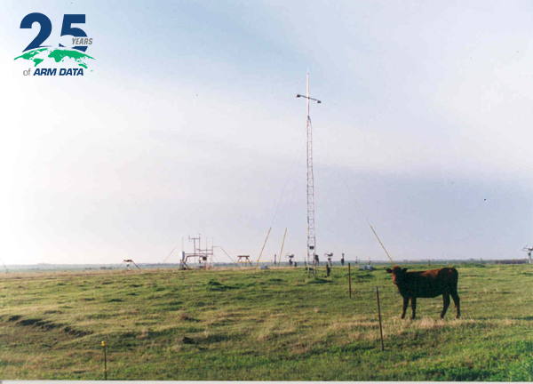
One day in May 1992, four men—two engineers, a scientist, and a local farmer—unloaded a Portable Automated Mesonet II (PAM II) from a truck on a cow pasture between Billings and Lamont, Oklahoma.
They assembled the tripod and pole for the PAM II’s slender tower, staked it to the ground with specialized rebar, and flipped a switch. The battery-powered device, fitted with a small solar panel, began to collect observations on wind speed and direction at 10 meters, temperature and relative humidity at 2 meters, barometric pressure, and precipitation rate.
Flipping that switch on Saturday, May 16, 1992, was one of those small moments with big consequences. The PAM II pulled down the very first data for the Atmospheric Radiation Measurement (ARM) Climate Research Facility, known then as the ARM Program.
Almost 25 years later, there is more than a petabyte of ARM data, distributed free, and used to test climate models and power research by scientists all over the world. Starting with the Southern Great Plains (SGP) Central Facility in weather-active Oklahoma, ARM broke the mold of using just field campaigns to collect detailed data on atmospheric processes relevant to climate. This U.S. Department of Energy (DOE) program set the global gold standard for 24/7 continuous collection of measurements vital to understanding clouds, the Earth’s radiation (energy) balance, and other climate-critical factors.
Let history note that the first operational ARM instrument, the PAM II of that May 16, was situated on a slight rise of ground at 36.604255,-97.485262. Of the four men working that day, two are deceased. The survivors are Danny Nelson, now a technologist at the Pacific Northwest National Laboratory (PNNL) in Richland, Washington, and Stanley Tomich, a research engineer at PNNL’s Marine Sciences Laboratory in Sequim, Washington.
“I didn’t realize the impact that (moment) had at the time,” says Nelson. “I really didn’t understand what ARM was going to be.”
Out of Concerns, a New Program
Few people really did. The longevity, operational durability, and influence of ARM was at first aspirational. The DOE intended the program to expand the collection of field observational data and to improve the predictive capabilities of climate models. The idea—spearheaded by a PNNL astrophysicist by the name of Gerald M. “Gerry” Stokes—rose out of growing concern over climate change among federal agencies in the 1980s and going all the way back to a DOE program on atmospheric carbon dioxide in the 1970s.
“We changed the way people do atmospheric science. We set a brand new standard,” says Stokes, who is now a research professor at Stony Brook University in New York. Twenty-five years ago he was widely regarded as the project’s visionary—a “philosopher king,” as one colleague put it. (Stokes was the first ARM chief scientist and stayed on until 1998.)
Immediately, ARM focused on gaps in scientific understanding, “how to do radiative transfer,” he says, “and how to consider clouds.”
ARM outlined a grand plan for a series of fixed observation sites in climatologically significant regions of the world. Before that, data were largely gathered during short-term field campaigns, (“Genghis Khan and the Mongol horde would descend on a place,” says Stokes). These were by nature periodic, limited regionally and temporally, and uncoordinated in the way data collected, standardized, archived and distributed—all problems that ARM eventually addressed.
“The founding fathers of ARM did a great job in anticipating needs,” says David D. Turner, a National Oceanic and Atmospheric Administration (NOAA) meteorologist working in Boulder, Colorado, and an ARM principal investigator for the past two decades. (He was also lead editor of a 30-chapter ARM history monograph that spells out the evolution of ARM, from SGP and beyond.)
Those anticipated needs, said Turner, included instrument mentors, the processes necessary to collect continuous data, and the practice of hiring local people as technicians.
The Raman lidar that runs operationally at several ARM sites is a good example. Before it was hardened for field work, operating it “was a three-Ph.D. activity,” he said. Now local technicians—some of them at SGP for 20-plus years already—handle the repair and maintenance of the Raman lidar and other similarly sophisticated gear.
Beyond the robust procedures and practices that started at SGP, Turner says the ARM model eventually inspired a series of observation sites internationally, including those in Germany, the Netherlands, France, the UK, and elsewhere.
Where It’s Important to Be
Meanwhile, campaigns—historically the way climate data were once collected—remain an ARM fixture, but they are called Intensive Operational Periods (IOPs), and are usually coordinated with continuous-data instrumentation at fixed sites.
Identifying the locations for those fixed sites was an early ARM challenge. Though the original program plan was silent on the matter, by 1991 a series of DOE reports had identified primary and supplementary sites—a wish list of locales that represented a desired variety of surface and atmospheric conditions. By 1997, three fixed sites were a reality—SGP, and sister observatories in the western Pacific and in Alaska.

The Oklahoma site was a natural first choice. It is dramatically stormy. (On his first day in the area it rained 5 inches, says Nelson, and he and other technicians were routinely chased off instrument sites by bolts of lightning close enough to raise hair.)
It was on U.S. soil; international and marine sites posed additional logistical challenges. It had roads—a plus for getting ARM infrastructure in place. And the environs of Lamont and Ponca City were in the middle of a region climatologically influenced by Canada, the Rocky Mountains, and the Gulf of Mexico. “Those weather patterns,” says Stokes, “waged war over Oklahoma.”
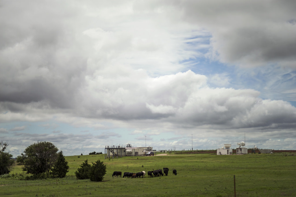
The SGP—which at its spatial peak spanned 55,000 square miles in Oklahoma and Kansas—turned out to be a proof-of-concept for many advances in data gathering that have matured and survived over 25 years.
Developed there, for instance, was the methodology for measuring water vapor profiles using the atmospheric emitted radiance interferometer (AERI). On that, Henry “Hank” Revercomb from the University of Wisconsin-Madison was in the lead during the 1990s. The site was also important to advances in radiosonde technology, and in the quality of radiometric calibration. (A “world-class” calibration site is still at SGP, says Stokes, transferable to international data standards.)
The Oklahoma facility was also the field laboratory for the single-column observational model; the efficacy of remote and boundary instrument sites; and the organizational leap of involving as many of DOE’s national laboratories as possible.
“My charge from Ari Patrinos [then Director of DOE’s Atmospheric and Climate Research Division] was to go out and find the best people in the laboratories to make this happen” smoothly, quickly, and cooperatively, says Stokes. Before a shovel-full of dirt was dug, he assigned tasks and future sites, at first, to five Labs. “It was us at our best,” says Stokes.
SGP, the First Observation Central
Doug Sisterson was named site manager at the SGP. Before getting the call from ARM in 1990 he was a busy and successful expert in acid rain at Argonne National Laboratory (ANL).
“I was the first guy,” says Sisterson of his new role, tasked to plan and execute everything within 18 months. “I learned how to follow the paradigm and get it done. I just charged ahead.”
Stokes had set on a timeline that called for the first site data to be collected in April 1992. (Since the timing was delayed slightly, he calls May 16, the day Nelson flipped the switch on the first PAM II, “the 46th of April.”)
Sisterson, years later, was lead author of the monograph chapter on how the SGP site grew. He was site manager there until 1999, filled other ARM roles, and is now ARM’s instrument operations manager. For the first 18 months of construction, he spent two weeks a month in Oklahoma, flying round trips so often that even the pilots got to know him.
SGP started as 160 acres—a quarter section—of pasture and wheat fields. It was leased from a Lamont farmer named Stanley Schuelein, now deceased, who was on hand for the first PAM II assembly. His plot of land had been identified by Geographic Information System at Argonne. “We knew where the middle of things had to be,” says Sisterson.
Back in those days, with a robust Internet more an aspiration than a reality, much of the data were transported from field instruments to the Central Facility by “sneakernet,” says Sisterson. That is, someone would collect floppy disks and run them to the nearest computer. “We were doing presentations then on clear vellum overheads,” he added.
Sisterson had a lot of set-up help. Jim Teske, a Navy veteran and one-time NOAA staffer ran day-to-day operations, overseeing everything from upgrading roads to siting trailers. He was not yet on the job, though, when Nelson and a colleague picked up 10 PAM II instruments from the National Center for Atmospheric Research (NCAR) in Boulder, Colorado. (Most of the first SGP instruments were leased from NCAR, and for a brief while that’s where the data went too, by satellite.)
In the early days, other key players sold local residents on the idea of so many scientific instruments in their midst, in a project that included the word “radiation.” Sisterson opened a “general store,” a small rented space for the SGP project office and community outreach run by Wayne Meadows from the Los Alamos National Laboratory (LANL).
It was connected to a small country store in Lamont where local farmers and ranchers would gather most days to talk about the weather, futures, and politics. “If you want to be a good neighbor,” says Sisterson, “you have to be part of the neighborhood.” Today, SGP is the third-largest employer in Grant, Oklahoma’s poorest county. Only schools and grain elevators have more people on the payroll.
One public relations problem turned out not to be a problem at all. An instrument called the radio acoustic sounding system (RASS) put out an alternating high whistle and deep warbling that could be heard from two miles away. “You had to tell people it wouldn’t startle and stampede their cattle,” says Sisterson. So bleachers were set up at a local farm for a public test, and farmers brought in 500 head of cattle, who set to grazing near the device. They never even looked up, and everyone went home.
In the campaign to be neighborly, it helped that a native Oklahoman, Argonne atmospheric scientist Jack D. Shannon, knocked on doors in Oklahoma and Kansas to get land leases for the extended and boundary facilities. (Shannon, who died in 2007, was the fourth man helping to assemble that PAM II in 1992.) Argonne meteorologist Marvin L. Wesely, who died in 2003, directed early instrument siting at the Central Facility.
Laurel Chapman, the recently retired ARM Science Liaison based at Argonne, also put in her time on behalf of the nascent SGP site—to great effect, says Nelson, praising her work ethic and insight. “Laurel was on board from Day One and was the glue that held everything together.”
Among many other steady voices during the startup at SGP was Sumner Barr of LANL, who had earlier helped assess candidate locales in the continental United States (DOE named eight in 1990) and who later helped establish measurement sites within SGP itself. Sisterson called him the “ARM program statesman,” and a personal mentor. “So many people gave their all in those early days,” he says.
SGP, and ARM, Grow Up
By 1995, the SGP site had reached its first full phase of operation, with one Central Facility, 20 extended facilities, and four boundary facilities—a flexible operational plot regime still in action today.
The idea, says Sisterson, was to install field instruments in such a way that the Central Facility got a vertical “soda-straw” view of conditions. Added to data from outlying sites, scientists got a good view of an energy budget—the atmosphere and radiative balances—within the 300×300 km grid cell of a climate model.
Early measures of balancing atmospheric warming of the sun’s radiant energy for clear skies were very successful. Today, ARM data appears “wherever you go,” says Sisterson, and SGP remains “the largest climate observatory in the world.”
Over time, models increased their resolution, and SGP has decreased its measurement footprint to approximately 150×150 km. Current SGP site manager Nicki Hickmon notes that instruments are now configured to support understanding of clouds and aerosols and their interaction with the Earth’s surface, all of which provides improved representation in earth system models.
In the 25 years since SGP transformed farmland to a world-class climate observation site, ARM has built on its decades in support of atmospheric and climate research to establish other fixed sites; on the books today are observatories in Alaska and the Azores.
Meanwhile, says Hickmon, there was a continued need for flexible instrumentation suites, so beginning in 2005 ARM developed and deployed three ARM Mobile Facilities (AMF). Over the last 12 years, AMFs have made measurements in locations around the world, from the Amazon to Antarctica.
In 2005, ARM also formalized its airborne operations as the ARM Aerial Facility (AAF). Both the mobile sites and a robust airborne research presence have been called for in ARM’s prescient early plans.
Nelson is aware how busy and big ARM has gotten in 25 years. He works for the AAF now and has a unique view of both the distant past and the emerging future. In late March he finished loading two sea containers with gear needed for an aerial campaign in the Azores.
“Good memories,” he says, looking back at the first PAM II and what rose out of that first flip of the switch. “Thanks for stirring them up.”
# # #
The ARM Climate Research Facility is a national scientific user facility funded through the U.S. Department of Energy’s Office of Science. The ARM Facility is operated by nine Department of Energy national laboratories.
The ARM Climate Research Facility is a DOE Office of Science user facility. The ARM Facility is operated by nine DOE national laboratories, including .
Follow Us:


Keep up with the Atmospheric Observer
Updates on ARM news, events, and opportunities delivered to your inbox
ARM User Profile
ARM welcomes users from all institutions and nations. A free ARM user account is needed to access ARM data.


