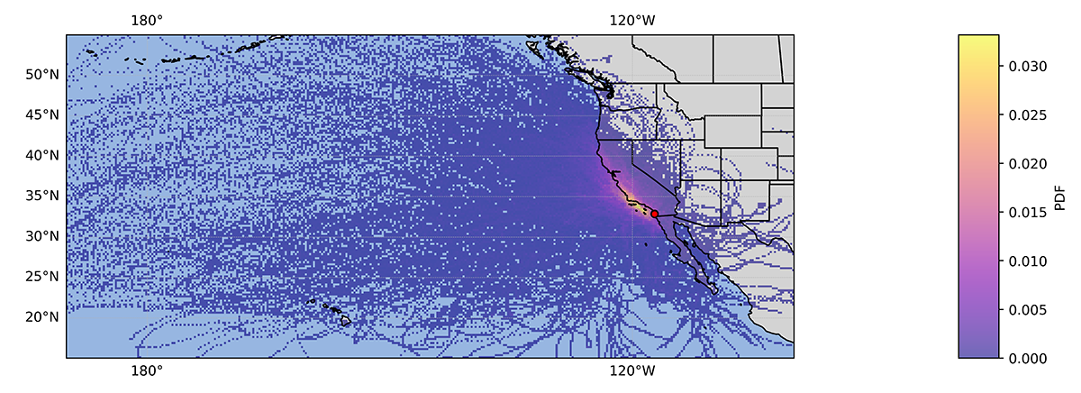
A new evaluation value-added product (VAP) from the Atmospheric Radiation Measurement (ARM) user facility provides back and forward trajectories for airmasses over ARM Mobile Facility deployments.
Data from the multipurpose ARM trajectory (ARMTRAJ) VAP can provide information on the likely history of airmasses before they were observed over an ARM site, such as origin and surface interaction. Moreover, back and forward trajectories can suggest that an airmass has passed over other ground-based measurement sites upwind and downwind, respectively.
ARMTRAJ data also enable better synthesis of ARM and satellite observations and can provide boundary conditions for modeling studies constrained by ARM data.
The ARMTRAJ VAP consists of four trajectory data sets to support atmospheric research using ARM data:
- surface aerosol (listed as the ARMTRAJSFC data product in ARM’s Data Discovery portal)
- distinct liquid-bearing cloud layers identified using radiosonde data (ARMTRAJCLD)
- primary cloud decks identified from ARM Active Remote Sensing of CLouds (ARSCL) VAP data (ARMTRAJARSCL)
- the planetary boundary layer (ARMTRAJPBL), with the layer height provided by ARM’s Planetary Boundary Layer Height (PBLHT) VAP.

All four trajectory data sets are initialized at ARM deployment coordinates and configured using ARM data sets. Trajectories are calculated using the Hybrid Single-Particle Lagrangian Integrated Trajectory (HYSPLIT) model informed by the European Centre for Medium-Range Weather Forecasts Reanalysis version 5 (ERA5) data set at its highest spatial resolution (approximately 31 kilometers).
Daily trajectory data files, available in netCDF format, include airmass coordinates and state variables extracted from ERA5 before and after an ARM site overpass. Back trajectories are available for all four data sets, and forward trajectories are also available for ARMTRAJCLD and ARMTRAJARSCL. Ensemble runs generated for each model initialization enhance trajectory robustness, while ensemble variability serves as a valuable uncertainty metric for reported airmass coordinates and state variables.
The initial set of ARMTRAJ evaluation data is now available for the 2023–2024 Eastern Pacific Cloud Aerosol Precipitation Experiment (EPCAPE) in La Jolla, California. After the VAP becomes operational, it will run for past, present, and future ARM deployments.
More information on ARMTRAJ is available on the VAP web page and in a recent Earth System Science Data preprint (Silber et al. 2024).
Access the data in the ARM Data Center. (To download the data, first create an ARM account.)
To ask questions, provide feedback on this VAP, or report data problems, please contact Israel Silber.
To cite the data, please using the following DOIs:
- ARMTRAJPBL: doi:10.5439/2309848
- ARMTRAJARSCL: doi:10.5439/2309849
- ARMTRAJSFC: doi:10.5439/2309850
- ARMTRAJCLD: doi:10.5439/2309851.
Reference: Silber I, Comstock JM, Kieburtz MR, and Russell LM. 2024. “ARMTRAJ: A Set of Multi-Purpose Trajectory Datasets Augmenting the Atmospheric Radiation Measurement (ARM) User Facility Measurements.” Earth System Science Data, in review, https://doi.org/10.5194/essd-2024-127.
# # #ARM is a DOE Office of Science user facility operated by nine DOE national laboratories.

