
Updated: Access New Gridded Cloud Radar Product for COMBLE Campaign
Published: 20 July 2023
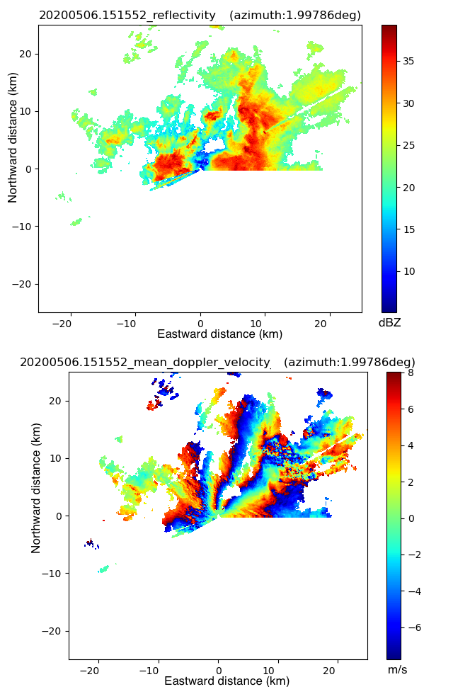
Editor’s note (July 20, 2023): A new KASACRGRIDPPI evaluation release for COMBLE, which uses b1-level calibrated PPI data as input, is now available. Output data from KASACRGRIDPPI are uncalibrated c1-level netCDF files, each comprising gridded observations for a single azimuthal scan. Surveillance scans are gridded for elevations of 0, 0.5, 1, and 2 degrees. Output variables include radar moments remapped onto a 2D Cartesian grid. Access the data from the ARM Data Center. To cite the c1-level data, please use doi:10.5439/1886546.
The Atmospheric Radiation Measurement (ARM) user facility released a new cloud radar value-added product (VAP) from the 2019–2020 Cold-Air Outbreaks in the Marine Boundary Layer Experiment (COMBLE) in northern Norway.
The Scanning ARM Cloud Radar Grid (SACRGRID) family of VAPs provides radar moments and quantities from scanning cloud radars on a Cartesian grid. The latest SACRGRID release consists of gridded plan position indicator (PPI) scans from the Ka-Band Scanning ARM Cloud Radar (KASACR), created with the KASACRGRIDPPI VAP.
This VAP and other gridded products from COMBLE make it easier for scientists to use scanning ARM cloud radar observations from the entire campaign. KASACRGRIDPPI is available for the COMBLE ARM Mobile Facility deployment near Andenes, Norway, from December 2019 through May 2020.
The gridded radar moments include reflectivity, mean Doppler velocity, spectral width, signal-to-noise ratio, and differential phase. The moments are accompanied by the linear depolarization ratio and copolar-to-crosspolar correlation coefficient.
Currently an evaluation product, KASACRGRIDPPI remaps the radar PPI-type scanning to a Cartesian grid. During COMBLE, the PPI scan strategy used consecutive surveillance scans for a 90- to 240-degree sector overlooking the ocean. The scans consisted of multiple elevation angles ranging from 0 to 2 degrees.
The input data are a1-level uncalibrated PPI data. A nearest neighbor algorithm is used for gridding, with a censor mask applied to flag significant echoes. Gaseous attenuation correction is also applied for the KASACR before gridding. This correction eliminates water vapor as a source of signal attenuation.
The output data are c0-level netCDF files, each comprising gridded observations for a single azimuthal scan. For this release, only the 2-degree elevation surveillance scans are gridded. Output variables include all aforementioned radar moments remapped onto a two-dimensional (2D) Cartesian grid. Note that calibrated reflectivity factor measurements will be available in a future c1-level data release.
Scientists can use the new COMBLE data now. For more information about KASACRGRIDPPI, go to the VAP web page.
Users are encouraged to provide feedback on the data quality and accuracy of this evaluation product. To give feedback or ask questions about the data, please contact Meng Wang or Scott Giangrande.
Access the KASACRGRIDPPI data in the ARM Data Center. (Go here to create an account to download the data.)
To cite these KASACRGRIDPPI data, please use doi:10.5439/1768878.
Follow Us:


Keep up with the Atmospheric Observer
Updates on ARM news, events, and opportunities delivered to your inbox
ARM User Profile
ARM welcomes users from all institutions and nations. A free ARM user account is needed to access ARM data.


