AMF3 Site Science Team Blog: Putting Maps to Work

 
Published: 18 May 2021

Editor’s note: A site science team led by Brookhaven National Laboratory in New York will develop a science plan and initial research project for the upcoming Southeastern U.S. (SEUS) deployment of the third ARM Mobile Facility (AMF3). Brookhaven associate ecologist Shawn Serbin, the site science team’s land-atmosphere interactions topical lead, provided the following blog update.

Shawn Serbin stares into the distance.
Shawn Serbin

Since our last blog post, we have continued to discuss science, siting, and instrumentation during our regular teleconferences with the full site science team (SST), topical subgroups, ARM/ASR program managers, site operations partners at Sandia National Laboratories, and SEUS partners (U.S. Forest Service) and measurement networks (AmeriFlux, NEON operations and scientists). We also have stayed engaged with the broader scientific community. The SST held virtual town halls during the 2020 American Geophysical Union (AGU) Fall Meeting and 2021 American Meteorological Society (AMS) Annual Meeting, providing updates on the status of the SEUS deployment, siting criteria, potential regions, and a summary of the overall scientific objectives of the deployment.

Throughout these outreach activities, our team has been actively engaged in articulating SEUS-relevant science drivers, defining a corresponding set of preferred siting criteria, and developing geographic information system (GIS) mapping capabilities. We are using GIS to quantitatively capture these scientific, logistical, and other siting requirements to provide more specific guidance on candidate regions in the SEUS. This effort utilizes a range of GIS and remote sensing data across many scientific domains to identify areas that meet SST-desired specifications for terrain, forest, aerosol, and cloud requirements. Let’s dig in a little deeper with some examples that our team has been working on.

Map shows terrain roughness/complexity in Southeastern United States
Terrain Roughness/Complexity: A siting consideration that cross-cuts science drivers and logistical requirements is terrain roughness/complexity (how much surface elevation changes within a defined area and scale). As an example, candidate siting regions for the AMF3 could both: (1) minimize the role of surface topography controls on cloud initiation/development and aerosol evolution, and also (2) enable optimal observational sampling by satisfying field-of-view or measurement requirements. Under this example, candidate siting regions would be characterized by relatively flat locations with low average slope and low terrain roughness, without undue peak/valley influences, circulations, and/or local rapid slope changes. This includes site placement at a distance from mountains, lakes, and rivers with a strong preference to avoid prominent river valley regions (e.g., Mississippi River and/or Savannah River watersheds) due to their attendant atmospheric controls on surface energy and water vapor fluxes. The map above illustrates terrain roughness (meters) across the SEUS, where the roughness value in each pixel (pixel resolution = 90 m x 90 m) is calculated as the absolute difference of elevation in that pixel and its closest eight neighboring pixels. (Map made in R)
Maps illustrate the LandFire 30-meter canopy cover (upper panel) and forest canopy height (lower panel) products, subset to the larger Southeastern U.S. region
Representative Forested Sites: Several SEUS science drivers require sites having a minimum contiguous area of similar forest/vegetation composition (species mix, e.g., oak-pine, pine, or hardwood) and plant structure (similar age structure, height, and/or tree diameters). A larger forested main site is preferred (depending on final deployment configuration), having sufficient canopy cover. Remote sensing and GIS tools provide larger-scale guidance for siting based on SST science requirements, but for specific candidate sites, detailed image analysis and in-person assessment will be needed. Additional land-atmosphere interaction considerations depend on the dominant species type, as needle-leaf evergreen pine forests will typically have a lower mean canopy cover than a deciduous broadleaf forest. Overall, forested sites should not be fragmented by large roads, rivers, ponds, clearings, or breaks (e.g., fire breaks, power lines). The maps above illustrate the LandFire 30-meter canopy cover (upper panel) and forest canopy height (lower panel) products, subset to the larger SEUS region. (Map made in QGIS)
Representative Air Mass Sampling and Regional Cloud Observational Networks: Aerosol science drivers require regionally representative sampling. It is desirable to have contributions from both urban and natural environments to study the role of human-caused and vegetative emissions (and their interactions) on aerosol properties and processes. Preferred siting regions could be characterized by exposure to a regionally representative range in human-caused (e.g., nitrogen dioxide, or NO2) and vegetative emissions (e.g., isoprene). The map above illustrates the annual column maximum value NO2 map (TROPOMI/TEMIS retrievals, 2018), with regional NOAA-National Weather Service NEXRAD locations (black circles) and associated radar ring buffers (100-kilometer radius) for optimal coverage. The NEXRAD network is an example of a potential SEUS-partner operational observational network that could enhance site measurement capabilities for science drivers that cross-cut aerosol and cloud topics. (Map made in R)

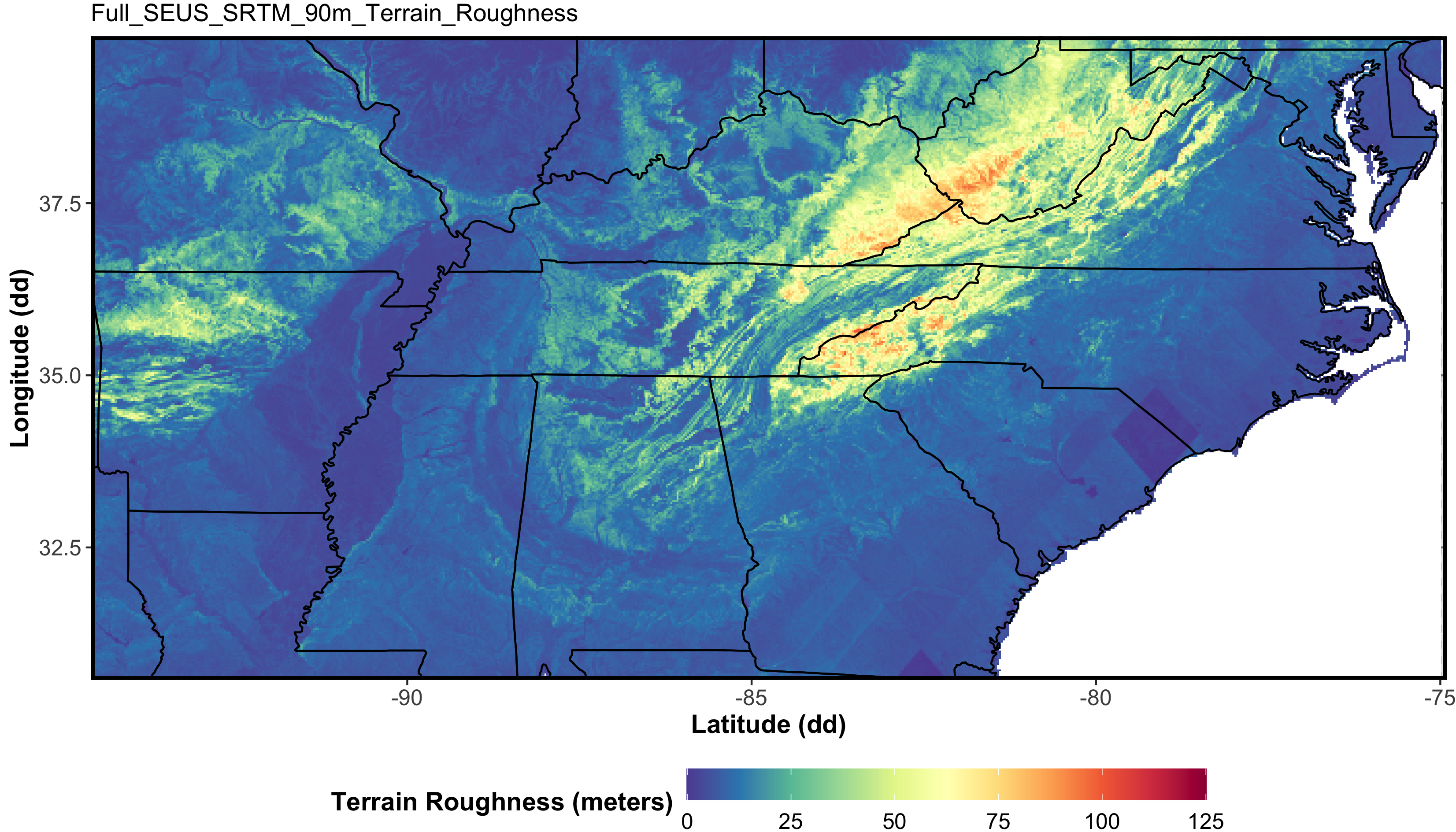
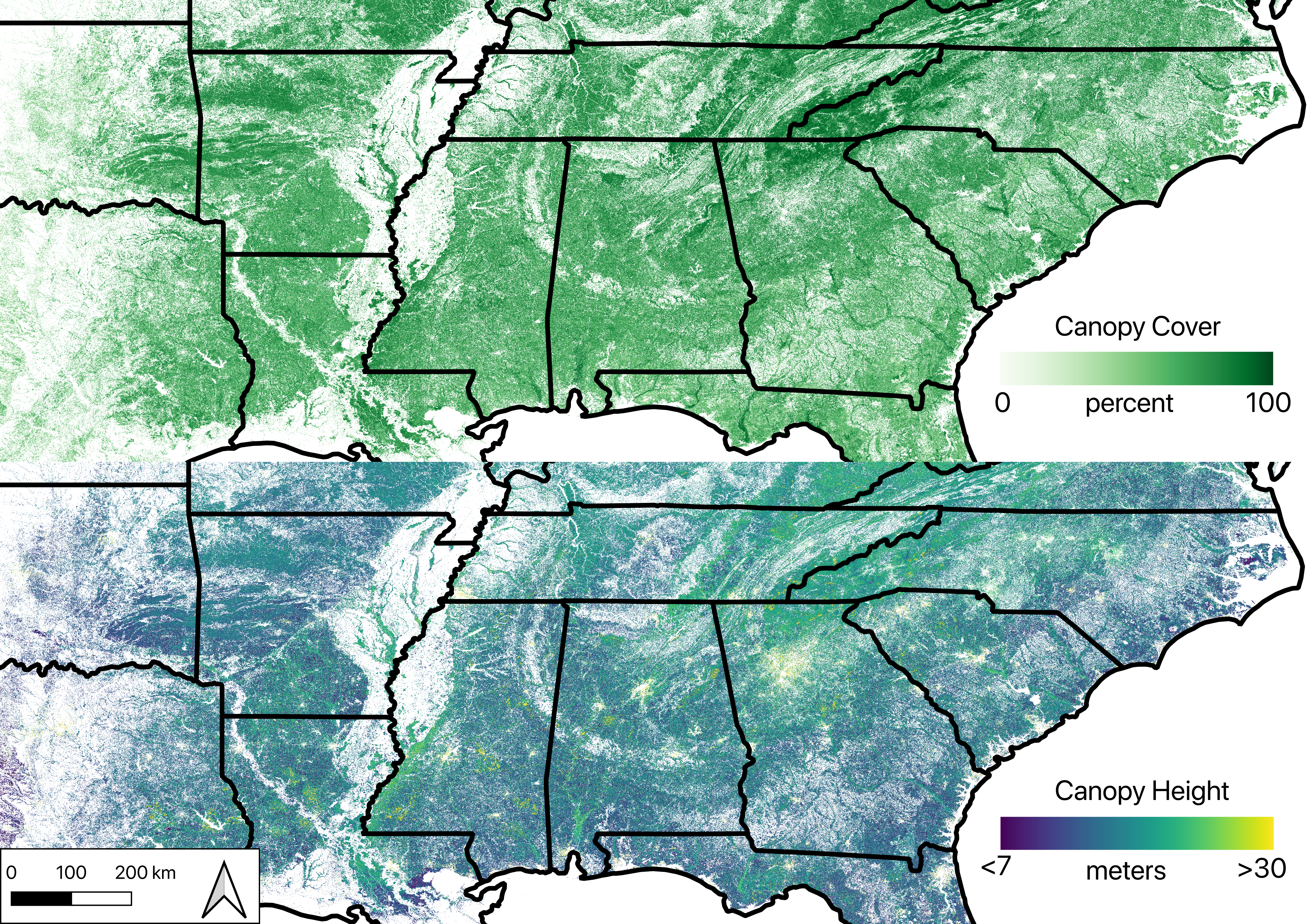
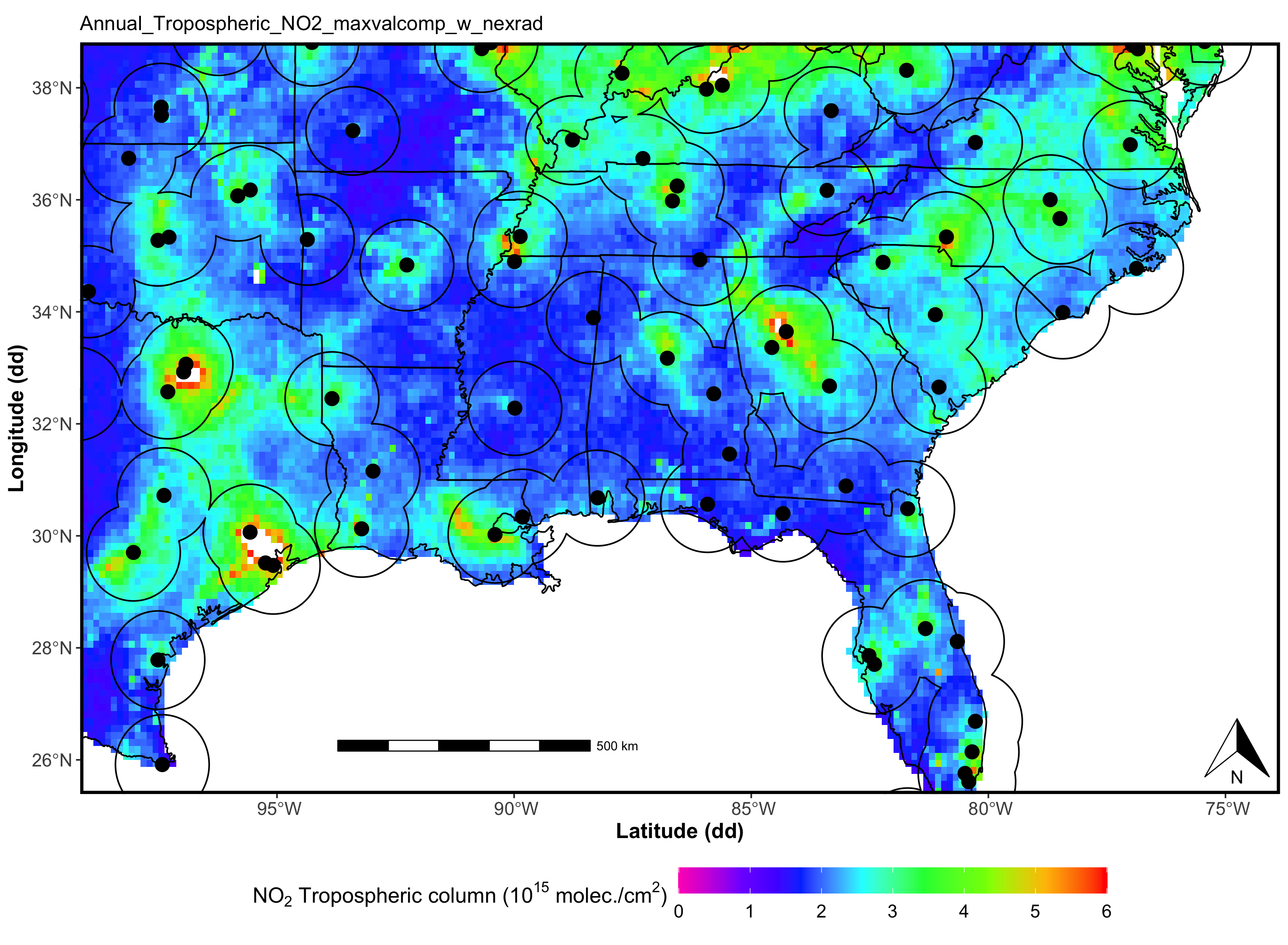
From these resulting individual guidance maps, our team has been developing composite maps where several GIS layers are analyzed together, showing where locations meet specific, joint requirements based on land-atmosphere interaction, aerosol, and cloud science drivers. These composite maps will motivate more specific exploration of these areas to assess other considerations (e.g., permitting, specific tower siting) and to provide a short list for in-person site visits to inform the site selection process.

As we are working toward our final site short list, we are selecting further specific GIS data sets in defining regional inclusion/exclusion areas, and further developing site deployment strategies and assessing their impacts on preferred siting criteria.

The SST looks forward to participating in the upcoming Joint ARM User Facility/ASR Principal Investigators Meeting and providing updates on our pre-deployment activities, and in the joint AmeriFlux/DOE Land-Atmosphere Interactions Workshop, where we look forward to additional opportunities to engage with the scientific community on SEUS science drivers, siting, and instrumentation.