

VALCLRADAR
The Storm Peak Lab Cloud Property Validation Experiment (STORMVEX)
15 November 2010 - 25 April 2011
Lead Scientist: Gerald Mace
Observatory: AMF (ARM Mobile Facility) - SBS
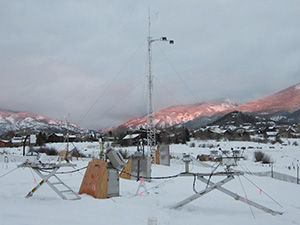
The core goals of the ARM Climate Research Facility included improving the representation of clouds in global models. To accomplish this goal, ARM invested considerably in creating long-term data sets from suites of ground-based remote sensors placed at climatically important locations around the world. However, the ability to convert the remote sensing measurements to cloud properties has been hampered by a critical shortage of correlative data that could be used for validation and development of new algorithms. Such correlative data sets are normally created by episodic and expensive aircraft measurements. The field deployment of the second ARM Mobile Facility (AMF2) provided the potential to create a correlative data set equivalent to between 200 and 300 aircraft flights in liquid and mixed phase clouds. This was achieved by placing the AMF2 in close proximity to an elevated platform that was heavily instrumented with aerosol, cloud and precipitation sensors. The Storm Peak Lab (SPL), located east of Steamboat Springs, Colorado, is a well-established cloud and aerosol research facility operated by the Desert Research Institute. SPL is located at 3210 meters above sea level and is above cloud base 25 percent of the time during the winter season. The already extensive instrument suite at SPL was augmented with additional state-of-the-art instruments that are typically used for airborne cloud research by the Stratton Park Engineering Corporation (SPEC). SPL and SPEC collected in situ cloud and precipitation property measurements while the AMF2 operated at a location approximately 2.4 kilometers west and 2078 meters in elevation during a winter season. This deployment addressed three long-standing ARM objectives:- From a cloud property retrieval perspective, the type of clouds that were observed during this period ranged from stable liquid phase boundary layer clouds to mixed phase clouds to heavily precipitating snow. These cloud types represented some of the most unique challenges for cloud property retrievals and the full Doppler spectra from the scanning cloud radar combined with other AMF2 measurements correlated with continuous in situ data facilitated development of new algorithms and statistically significant validation of the algorithm results.
- The data set was collected in a region of complex terrain. Collecting such a data set has been a long standing goal of ARM and presented a unique challenge and opportunity for modeling groups.
- The extensive aerosol data set that was collected at SPL allowed for investigation of the role of natural and anthropogenic aerosol in cloud and precipitation processes.
Campaign Links
Related Publications
View all- Andrews et al. "Harmonized aerosol size distribution, cloud condensation nuclei, chemistry and optical properties at 10 sites". 2025. 10.1038/s41597-025-04931-y.
Related Campaigns
- Colorado: CFH/CMH Deployment to StormVEx
- Colorado: StormVEX Aerosol Size Distribution
- Colorado : Cavity Attenuated Phase Shift
Co-Investigators
Roger Marchand
Ian McCubbin
Timeline
Campaign Data Sets
| IOP Participant | Data Source Name | Final Data |
|---|---|---|
| Gannet Hallar | Aerodynamic Part Sizer | Order Data |
| Gannet Hallar | Cloud Condensation Nuclei Counter | Order Data |
| Gannet Hallar | Cloud Aerosol Precip Spectrometer(CAPS)/Cloud Imaging Probe (CIP) | Order Data |
| Gannet Hallar | Condensation Particle Counter | Order Data |
| Gannet Hallar | Forward Scattering Spectrometer Probe | Order Data |
| Gannet Hallar | Precipitation Imaging Probe- Stormpeak Lab | Order Data |
| Gannet Hallar | Scanning Mobility Particle Sizer | Order Data |
| Chuck Long | Radiative Flux Analysis- Storm Peak Site | Order Data |
| Chuck Long | Total Sky Imager- Ground | Order Data |
SBS Data Sources
| Name | Full Name | Browse Data |
|---|---|---|
AOD-MFRSR
|
Aerosol Optical Depth (AOD) derived from MFRSR measurements | Browse Data |
AOP
|
Aerosol Optical Properties | Browse Data |
AOSMET
|
Meteorological Measurements associated with the Aerosol Observing System | Browse Data |
CCN
|
Cloud Condensation Nuclei Particle Counter | Browse Data |
CEIL
|
Ceilometer | Browse Data |
CPC
|
Condensation Particle Counter | Browse Data |
CSPHOT
|
Sunphotometer | Browse Data |
ECOR
|
Eddy Correlation Flux Measurement System | Browse Data |
GNDRAD
|
Ground Radiometers on Stand for Upwelling Radiation | Browse Data |
HSRL
|
High Spectral Resolution Lidar | Browse Data |
MET
|
Surface Meteorological Instrumentation | Browse Data |
MFRSR
|
Multifilter Rotating Shadowband Radiometer | Browse Data |
MPL
|
Micropulse Lidar | Browse Data |
MWR
|
Microwave Radiometer | Browse Data |
MWR3C
|
Microwave Radiometer, 3 Channel | Browse Data |
MWRRET
|
MWR Retrievals | Browse Data |
NEPHELOMETER
|
Nephelometer | Browse Data |
OZONE
|
Ozone Monitor | Browse Data |
PBLHT
|
Planetary Boundary Layer Height | Browse Data |
PSAP
|
Particle Soot Absorption Photometer | Browse Data |
QCRAD
|
Data Quality Assessment for ARM Radiation Data | Browse Data |
RWP
|
Radar Wind Profiler | Browse Data |
SEBS
|
Surface Energy Balance System | Browse Data |
SKYRAD
|
Sky Radiometers on Stand for Downwelling Radiation | Browse Data |
SONDE
|
Balloon-Borne Sounding System | Browse Data |
SONDEADJUST
|
Sonde Adjust | Browse Data |
SWACR
|
W-Band (95 GHz) ARM Cloud Radar, mounted to scan | Browse Data |
TSI
|
Total Sky Imager | Browse Data |
Follow Us:


Keep up with the Atmospheric Observer
Updates on ARM news, events, and opportunities delivered to your inbox
ARM User Profile
ARM welcomes users from all institutions and nations. A free ARM user account is needed to access ARM data.


Atmospheric Radiation Measurement (ARM) | Reviewed
March 2025