

ARM data-oriented metrics and diagnostics facilitates use of field data in climate model evaluation
Submitter
Zhang, Chengzhu Jill
— Lawrence Livermore National Laboratory
Xie, Shaocheng — Lawrence Livermore National Laboratory
Area of Research
General Circulation and Single Column Models/Parameterizations
Journal Reference
Zhang C, S Xie, C Tao, S Tang, T Emmenegger, J Neelin, K Schiro, W Lin, and Z Shaheen. 2020. "The ARM Data-oriented Metrics and Diagnostics Package for Climate Models - A New Tool for Evaluating Climate Models with Field Data." Bulletin of the American Meteorological Society, 101(10), 10.1175/BAMS-D-19-0282.1.
Science
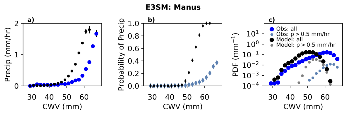
Figure 2. (a) Precipitation conditionally averaged on column water vapor (CWV) for observations based on ARMBE precipitation and gap-filled MWRRET radiometer CWV (blue) and E3SM model output (black) over Manus Island, Papua New Guinea. (b) as in (a) but for precipitation probability (the number of CWV observations with rain rates greater than a small threshold, here 0.5 mm/hr, divided by the total number of CWV samples in each bin). (c) The PDFs of CWV for observations (dark blue) and model (black) and of the contribution to this from points with precipitation exceeding 0.5 mm/hr for observations (light blue) and model (grey). From journal.
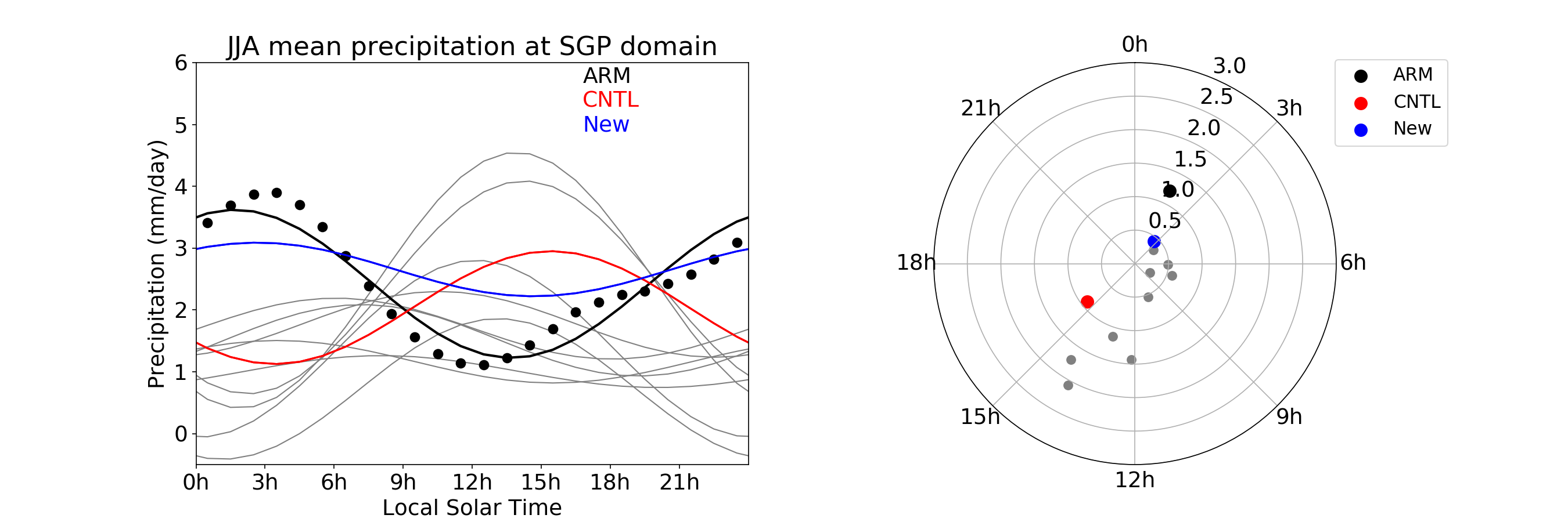
Figure 1. Left: black dots are ARM observations. Curves are the first harmonics: grey is for CMIP5 model AMIP type of runs. Color curves are from DOE’s E3SM (Energy Exascale Earth System Model) Atmosphere Model (EAM v1) with a standard control run and a run using newly developed convection triggers. Right: mapping precipitation peak time and amplitude (mm/day) from the first harmonics to polar coordinate. From journal.
Climate model developers often use a set of standard metrics and diagnostics as a way of routinely assessing general model performance or judging the performance of new physical parameterizations. ARM data can help to address a range of issues, including diagnosing summertime warm bias, the metrics of convective onset, precipitation distribution, and the diurnal cycle of both cloud fraction and precipitation.
Impact
Climate model developers routinely use satellite remote sensing to calibrate and tune models. But employing detailed, high-frequency ground measurements with a tool like ARM-DIAGS provides a complementary test in evaluating models. To date, ARM data have not been extensively used in model development workflows. With growing interest in improving parameterization using process-oriented metrics and diagnostics, ARM observations should play a more important role, especially in the way cloud and precipitation processes are represented in climate models. Inclusion of ARM-DIAGS in evaluation workflow allows climate modelers to compare their models with ARM data and supplemented CMIP data sets.
Summary
ARM’s high-frequency and long-term data sets are unique and invaluable in developing and improving climate models. A metrics and diagnostics package called ARM-DIAGS has been developed to further facilitate the use of ground-based ARM measurements in evaluating climate models. It includes both ARM data sets, CMIP data, and a Python-based analysis toolkit for computation and visualization. The package can serve as an easy entry point for climate modelers to compare their models with ARM data and supplemented CMIP data sets.
Follow Us:


Keep up with the Atmospheric Observer
Updates on ARM news, events, and opportunities delivered to your inbox
ARM User Profile
ARM welcomes users from all institutions and nations. A free ARM user account is needed to access ARM data.


