

Propagating Information Content: An Example with Advection
Submitter
Turner, David D.
— NOAA Global Systems Laboratory
Wagner, Timothy — University of Wisconsin–Madison
Area of Research
Atmospheric Thermodynamics and Vertical Structures
Journal Reference
Turner D, M Cadeddu, J Simonson, and T Wagner. 2025. "Propagating information content: an example with advection." Atmospheric Measurement Techniques, 18(14), 10.5194/amt-18-3533-2025.
Science
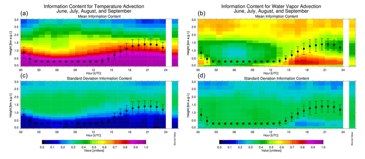
The mean diurnal information content for temperature advection (a) and water vapor advection (b) for the “warm season” (June, July, August, September). The variability of the information content, represented as the standard deviation, over this 4-month period is shown in the panels (c) and (d), respectively. The black dots illustrate the mean depth of the atmospheric boundary layer, which is derived from thermodynamic retrievals using a parcel method, with the error bars indicating the variability of this height for each time over the days included in the analysis. The single bar on the right side of all four panels shows the value averaged over the entire diurnal cycle.
This study provides a methodology to propagate the uncertainties of geophysical variables retrieved from multiple remote sensors in order to estimate the information content of derived quantities. A practical example is provided for water vapor and temperature advection fields derived from remotely sensed temperature, water vapor, and wind profiles.
Impact
The methodology developed in this work, which was demonstrated using advection observations, can be readily applied to other derived products that use one or multiple remote sensors operating in one or multiple locations. Because the methodology accounts for the instrument noise, it can be used to quantify the impact of a sensor degradation over time. This methodology can also be applied to Observing System Simulation experiments to understand how much information can be gained by the addition or elimination of one instrument not only on the retrieved variables, but also on all products that use that specific system.
Summary
New data products can be derived by combining variables retrieved from multiple different remote sensors. However, each sensor has their own uncertainties and information content – the amount of information that can be gleaned from the retrieval (i.e., the degrees of freedom for the signal; DFS). In this work, we propagate the uncertainties and information content from multiple instruments through the derivation equation to provide the uncertainties and information content of the derived quantity using the derivation of water vapor and temperature advection at the Southern Great Plains (SGP) site. A multi-month analysis demonstrates that the information content for temperature advection is nearly unity for all heights below 700 m (i.e., DFS close to 1), suggesting that if there is a true change in the temperature advection below that level, then the observed temperature advection would capture the magnitude of that change at the right level. For water vapor advection the information content varies as a function of height, time of day, and season; nonetheless, the daytime mean information content in the boundary layer in the warm season is above 0.7, suggesting that the magnitude of any true perturbation in the water vapor advection would be largely captured by this instrument suite.
Follow Us:


Keep up with the Atmospheric Observer
Updates on ARM news, events, and opportunities delivered to your inbox
ARM User Profile
ARM welcomes users from all institutions and nations. A free ARM user account is needed to access ARM data.


