

Deep learning of PBL heights using ARM SGP data
Submitter
Zhang, Yunyan — Lawrence Livermore National Laboratory
Su, Tianning — Lawrence Livermore National Laboratory
Area of Research
Atmospheric Thermodynamics and Vertical Structures
Journal Reference
Su T and Y Zhang 2024. "Deep-learning-derived planetary boundary layer height from conventional meteorological measurements." Atmospheric Chemistry and Physics, 24(11), 10.5194/acp-24-6477-2024.
Science
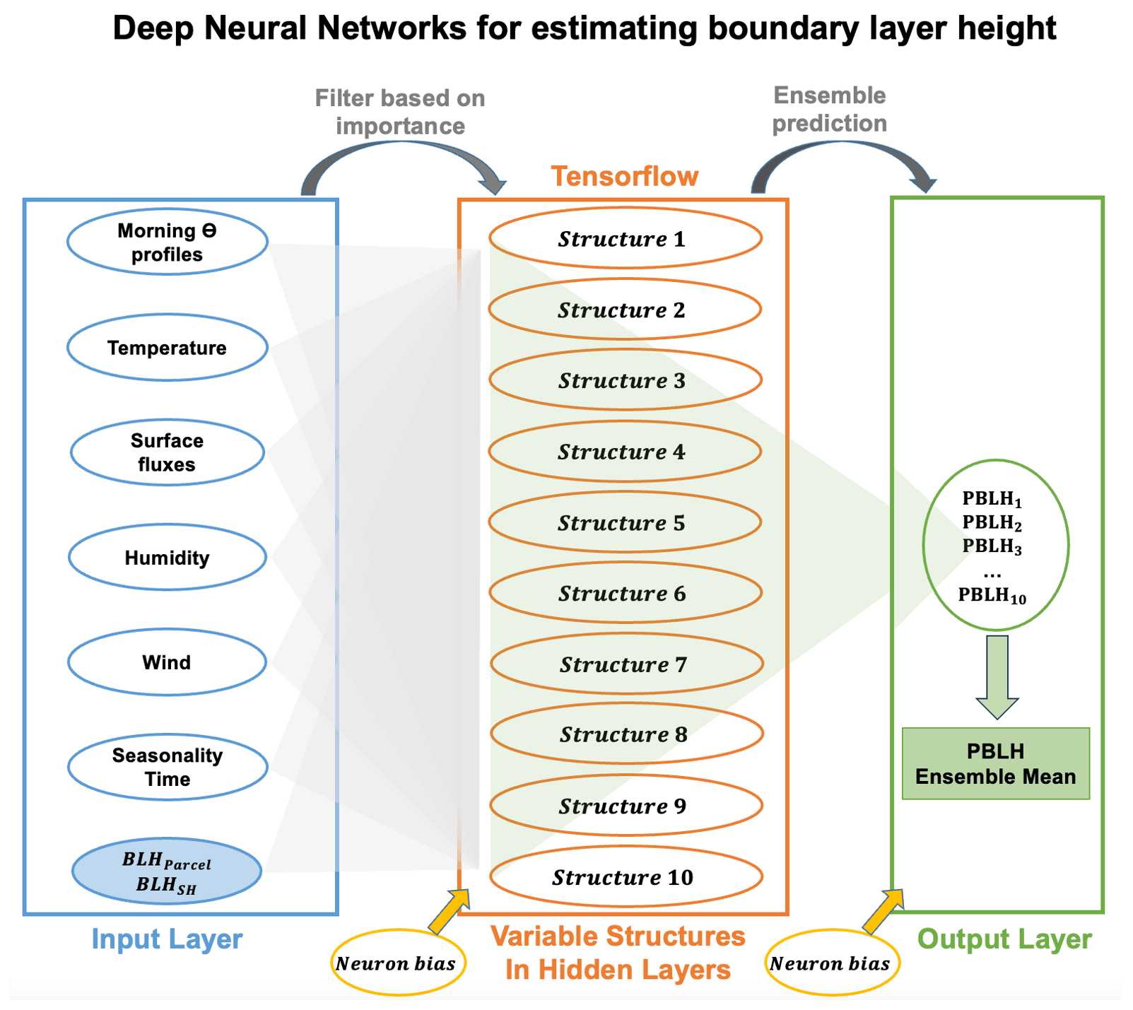
Schematic of the multi-structure deep neural networks (DNNs) used for estimating the planetary boundary-layer height (PBLH). Input features, including morning potential temperature profiles, surface air temperature, wind, humidity, surface fluxes, seasonality, and time, are filtered based on importance and fed into the network. The system comprises 10 distinct hidden-layer structures, each processing the inputs to model PBLH. The outputs from these structures are then synthesized to determine the final PBLH value, leveraging the diverse representations of atmospheric properties captured by each neural network configuration. Neuron biases are applied at the output and hidden layers to fine-tune the model's performance. Image from journal.
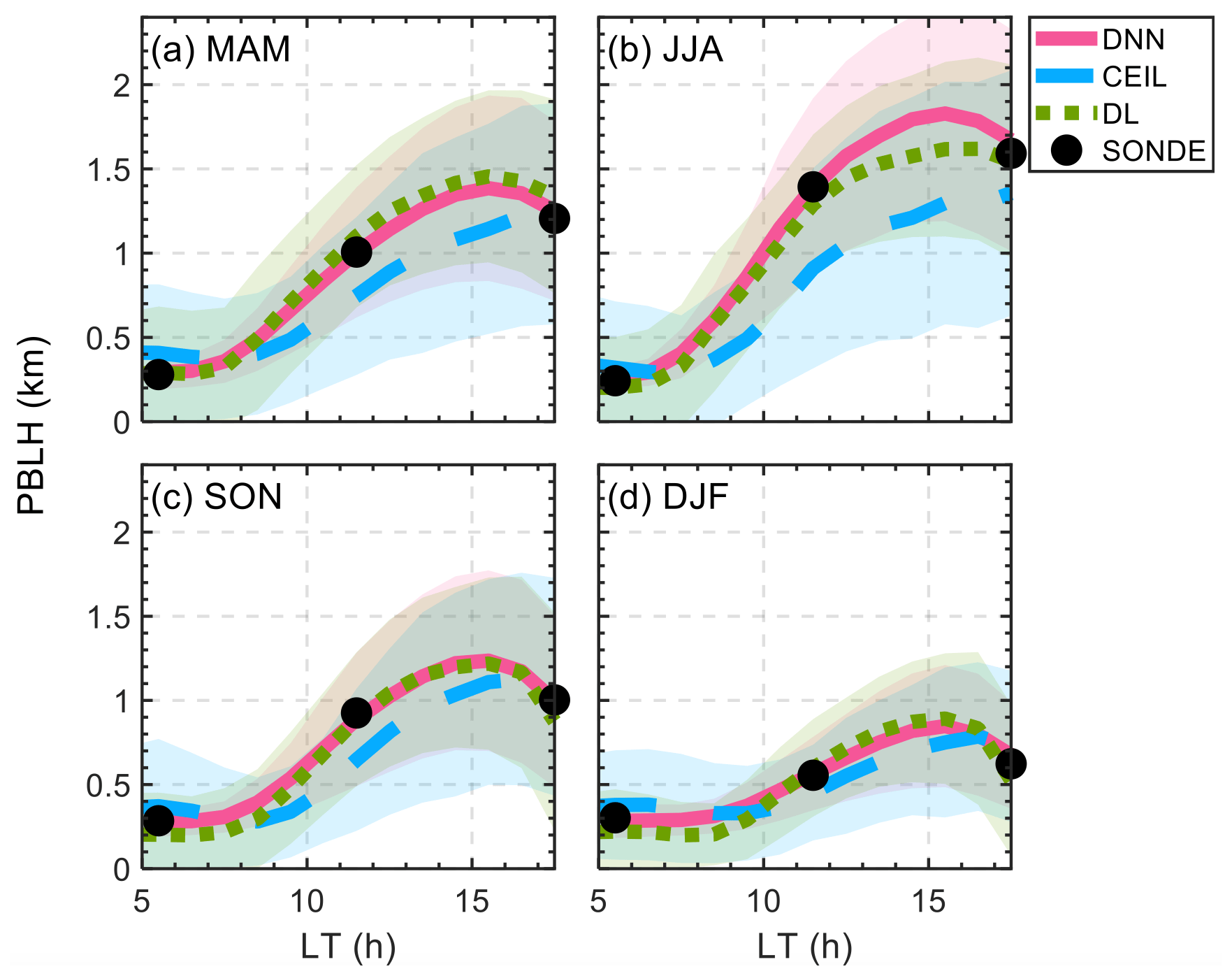
Seasonally averaged daytime evolution of the PBLH derived from various methods. The panels represent the mean PBLH values throughout the day for different seasons: (a) March–April–May (MAM), (b) June–July–August (JJA), (c) September–October–November (SON), and (d) December–January–February (DJF). The PBLH values estimated by the DNN are shown in red, ceilometer-derived (CEIL) estimates are in blue, Doppler lidar-derived (DL) estimates are in green, and observed radiosonde (SONDE) data are in black. Shaded areas around the lines indicate the standard deviations within each method. Image from journal.
This study developed an advanced deep learning model to estimate the planetary boundary-layer height (PBLH) by using morning sounding data and surface meteorological conditions. By training data from Atmospheric Radiation Measurement (ARM) user facility observations, our model examines the influence of various meteorological factors on PBLH and demonstrates effectiveness across different scenarios, offering a reliable tool for understanding atmospheric boundary-layer development.
Impact
This model of deep neural network (DNN) accurately estimates PBLH using conventional weather data as inputs, extending the ARM Southern Great Plains (SGP) atmospheric observatory data set back to 1994 and circumventing the limitations of relying on remote-sensing technologies. This observational-based DNN can also be initialized with reanalysis data, offering broad applicability to other locations. Additionally, it has potential as a diagnostic tool for evaluating model performance in simulating PBL development.
Summary
PBLH is a crucial variable to characterize turbulence development and transport of heat, moisture, and mass in various meteorological and climate conditions. This study introduces a multi-structure DNN model designed to estimate daytime evolution of PBLH by integrating morning temperature profiles with surface meteorological observations. By leveraging an extensive data set derived from long-standing radiosonde records, augmented with high-resolution micropulse lidar and Doppler lidar observations, the DNN model produces a robust 27-year PBLH data set over the SGP from 1994 to 2020. The model evaluates the influence of different meteorological factors on PBLH through an importance test and features an ensemble of 10 distinct hidden-layer structures to enhance accuracy and robustness. The DNN model's performance, validated against radiosonde observations and compared with conventional remote-sensing methods like Doppler lidar, ceilometer, Raman lidar, and micropulse lidar, shows lower biases and reliable performance across diverse conditions. Furthermore, the model, originally trained over a plain region at ARM's SGP site, demonstrates remarkable adaptability to heterogeneous terrains and climates, such as those in ARM's GoAmazon (tropical rainforest) and CACTI (mountainous) field campaigns.
Follow Us:


Keep up with the Atmospheric Observer
Updates on ARM news, events, and opportunities delivered to your inbox
ARM User Profile
ARM welcomes users from all institutions and nations. A free ARM user account is needed to access ARM data.


