

On CCN effects upon convective cold pool timing and features
Submitter
Lasher-Trapp, Sonia — University of Illinois at Urbana-Champaign
Area of Research
Cloud-Aerosol-Precipitation Interactions
Journal Reference
Ross T and S Lasher-Trapp 2024. "On CCN Effects upon Convective Cold Pool Timing and Features." Monthly Weather Review, 152(3), 10.1175/MWR-D-23-0154.1.
Science
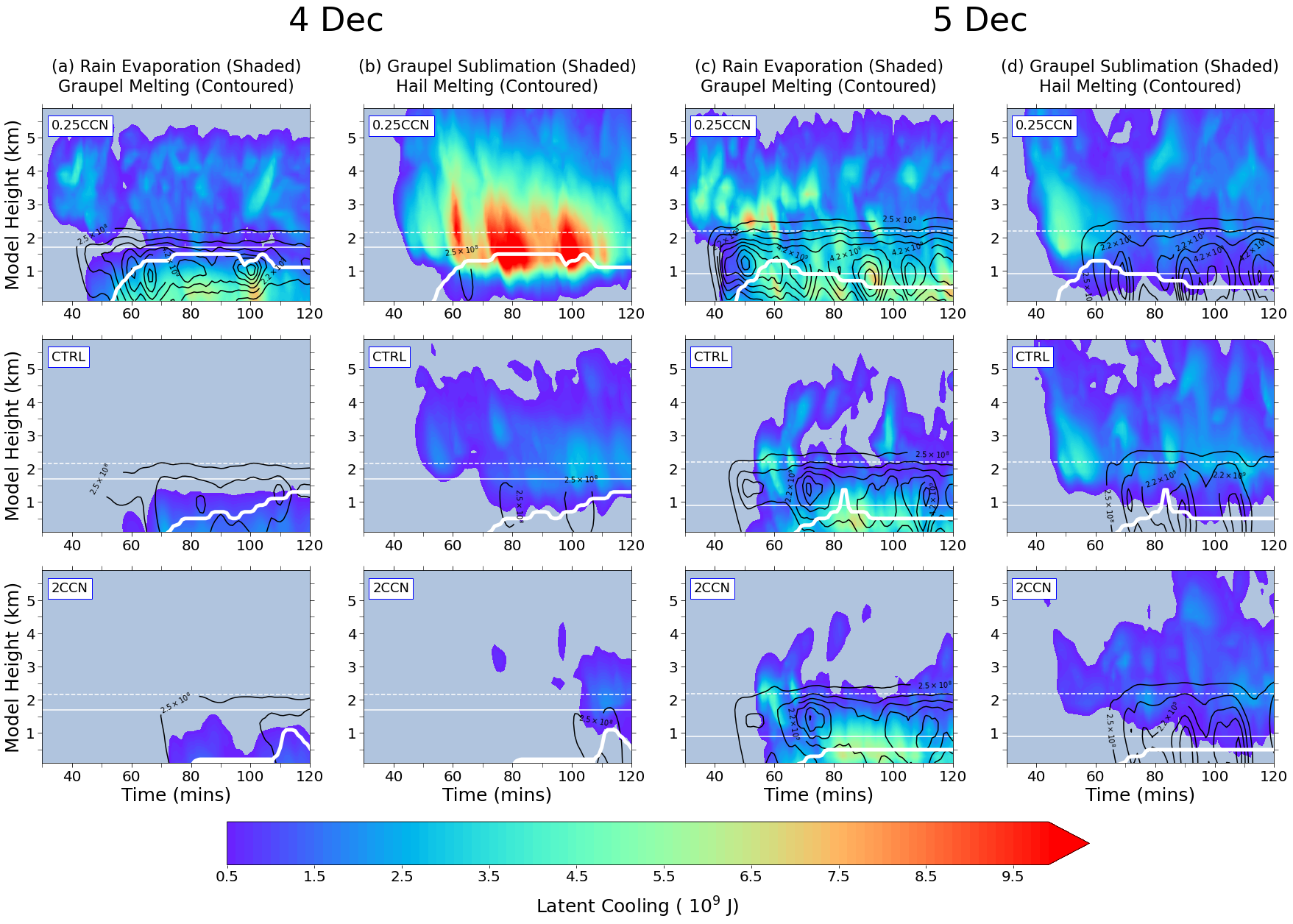
Figure 2. Convective cold pool strength and depth is determined by the amount of latent cooling in their parent downdrafts that result from phase changes in precipitation as it falls toward the ground. Here, time–height diagrams from simulation results illustrate how the latent cooling terms decrease with increasing amounts of environmental CCN, at least for the ordinary thunderstorm shown in columns (a,b), resulting in shallower cold pools (denoted by bold white contour). In columns (c,d) the same analysis for a supercell storm indicates that factors other than CCN are generally controlling the latent cooling and thus the cold pool. In all plots, solid thin horizontal white line denotes storm base height, and dashed horizontal white line denotes 0C isotherm. Image from journal.

Figure 1. An example of the multi-sensor approach to estimate the time of surface cold pool initiation using ARM assets from the 29 Nov storm observed during CACTI, with times indicated in each panel. (a) Low-level radar reflectivity shows the storm that produced the cold pool; (b) XSACR hemispheric RHI scan of radar radial velocity along the blue dotted line in (a), with the red box highlighting stronger speeds indicative of the cold pool expansion, and 20-dBZ reflectivity contour in black denoting storm outline; and (c) AMF1 surface meteorological station time series with the shaded rectangle indicating when the temperature fall and wind direction shift, marking that the cold pool passage occurred. By working backwards through successive XSACR RHI scans and co-located surface observations, the time of the first detectable cold pool was estimated for each case. Image from journal.
Field observations, and numerical modeling based on those observations, suggest that environments with more CCN can delay and weaken the first precipitation, and thus the first cold pools, produced by ordinary thunderstorms. Supercell thunderstorms appear to be less susceptible to these CCN effects.
Impact
Based on the results of this study, consideration of the impact of CCN in cold pool parameterizations appears warranted, especially in environments where supercell thunderstorms are not favored.
Summary
Data sets obtained from the CACTI/RELAMPAGO field campaigns in Argentina, along with idealized numerical modeling, were used to investigate the hypothesis. Aircraft observations of CCN and shallow convection on nine days during CACTI did suggest that drizzle formation was delayed on days with more environmental CCN. Three of those cases later developed into deep convection, and CACTI/RELAMPAGO radar data and ground-based measurements were used to estimate the timing of the first appearance of their respective cold pools. Two of the three cases were ordinary thunderstorms and seemed to imply a delay in the timing of the cold pool in environments with more CCN. Idealized numerical simulations of one of these storms also suggested weaker, slower-moving, and shallower cold pools in higher CCN environments. The third observed case was a supercell thunderstorm that did not follow the expected trend. Idealized simulations of the supercell case suggest that CCN effects on its precipitation and cold pool can be easily overpowered by its unique dynamics.
Follow Us:


Keep up with the Atmospheric Observer
Updates on ARM news, events, and opportunities delivered to your inbox
ARM User Profile
ARM welcomes users from all institutions and nations. A free ARM user account is needed to access ARM data.


