

Intercomparison of field data from LASIC, CLARIFY, and ORACLES
Submitter
Barrett, Paul — Met Office - UK
Zuidema, Paquita — University of Miami
Area of Research
Aerosol Properties
Journal Reference
Barrett P, S Abel, H Coe, I Crawford, A Dobracki, J Haywood, S Howell, A Jones, J Langridge, G McFarquhar, G Nott, H Price, J Redemann, Y Shinozuka, K Szpek, J Taylor, R Wood, H Wu, P Zuidema, S Bauguitte, R Bennett, K Bower, H Chen, S Cochrane, M Cotterell, N Davies, D Delene, C Flynn, A Freedman, S Freitag, S Gupta, D Noone, T Onasch, J Podolske, M Poellot, S Schmidt, S Springston, A Sedlacek III, J Trembath, A Vance, M Zawadowicz, and J Zhang. 2022. "Intercomparison of airborne and surface-based measurements during the CLARIFY, ORACLES and LASIC field experiments." Atmospheric Measurement Techniques, 15(21), 10.5194/amt-15-6329-2022.
Science
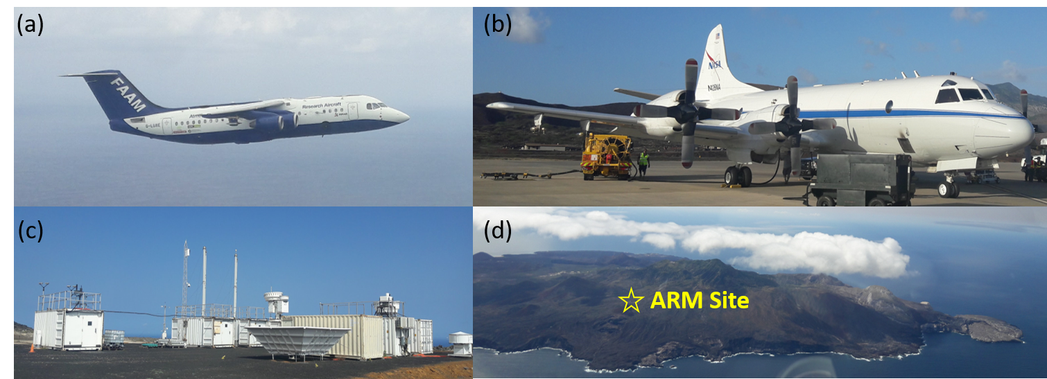
Figure 1. The observation platforms during (a) CLARIFY: the FAAM BAe-146; (b) ORACLES: the NASA P3; and (c) LASIC: ARM Mobile Facility no. 1. (d) The location of the ARM Mobile Facility no. 1 on Nasa Road, Ascension Island. This photograph was taken looking approximately north-north-east, showing the site exposed to the prevailing south-westerly winds. From journal.
Multiple field campaigns took place in the southeast Atlantic over a number of years with the aim of characterising the impact that smoke from fires on the African continent have on modulating the climate system. Using a range of techniques, these projects assessed the physical, chemical, and optical properties of this biomass burning aerosol (BBA) and co-located clouds and atmospheric radiation.
Impact
We have demonstrated and quantified the levels of consistency between the various sampling techniques and systems on the three platforms, thus enhancing the confidence in the measurements of the observed properties of the biomass burning aerosol and associated phenomena. This in turn leads to greater confidence in the outputs of climate simulations that either predict or incorporate the observed properties or impacts of biomass burning aerosols.
Summary
The U.S. Department of Energy first ARM Mobile Facility was located on Ascension Island in the SE Atlantic between June 2016 and October 2017, sampling two full BBA seasons (typically August to October). The FAAM BAe146 aircraft joined from the UK in August/September 2017, flying nearly 100 hours, while the NASA P3 flew over 350 hours across three BBA seasons between 2016 and 2018.
Motivating this study was the requirement to reconcile differences in the specific sampling methods and observation techniques employed on each platform in the real-world environment (as opposed to a well-controlled laboratory). It was demonstrated that aerosol optical absorption properties agreed within uncertainty limits as did solar radiation measurements, thus permitting closure studies. Difficulties still remain, however, as aerosol optical scattering and chemical composition measurements compared better between airborne platforms than between aircraft and the ARM site, suggesting some unidentified source of sampling bias.
This work is a crucial component in understanding spatial and seasonal variations in the observations. The combined data sets provide a well-characterized and comprehensive set of observations that will be useful in developing and evaluating climate simulations for many years to come.
Follow Us:


Keep up with the Atmospheric Observer
Updates on ARM news, events, and opportunities delivered to your inbox
ARM User Profile
ARM welcomes users from all institutions and nations. A free ARM user account is needed to access ARM data.


