

Identifying green vegetation variability over the Southern Great Plains
Submitter
Fast, Jerome D
— Pacific Northwest National Laboratory
Area of Research
Aerosol Processes
Journal Reference
Chand D, L Berg, J Tagestad, B Putzenlechner, Z Yang, S Tai, and J Fast. 2022. "Fine scale variability in Green Vegetation Fraction Over the Southern Great Plains using Sentinel-2 satellite: A case study." Remote Sensing Applications: Society and Environment, 27, 10.1016/j.rsase.2022.100799.
Science
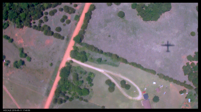
Figure 1. Conventional medium-resolution satellite observations miss the fine-scale variability shown in this image, biasing green vegetation fraction estimates. Image courtesy of the Atmospheric Radiation Measurement Aerial Facility (G-1 Aircraft).
Large uncertainties persist in simulations of near-ground meteorological properties made using weather forecasting models associated with specifying surface properties, including the plant canopy. Scientists frequently derive details of the plant canopy for numerical weather prediction models using the Moderate Resolution Imaging Spectroradiometer (MODIS) satellite. MODIS’s 500-meter resolution cannot resolve fine-scale detail in vegetation cover, such as variability across a field or changes in vegetation near a river. To fill the gap, researchers developed an approach to retrieve the green vegetation fraction (GVF) using Sentinel-2 satellite data at 10-m resolution. They compared their results to available coarser-resolution platforms including MODIS, Sentinel-3, and the Department of Energy’s Atmospheric Radiation Measurement (ARM) user facility Aerial Facility observations.
Impact
Surface properties that play a critical role in determining how much of the sun’s energy is absorbed at the surface and how much is reflected to the atmosphere, like albedo, depend on many factors. GVF is one factor needed to accurately simulate albedo and how energy partitions into fluxes of heat and moisture. The newly developed approach to estimating GVF has the potential to represent surface properties more realistically and to contribute to the development of land-surface parameterizations in numerical weather prediction models.
Summary
GVF at a high spatial resolution (10 m) is retrieved by applying a new method based on image analysis using multiple spectral bands from the Sentinel-2 satellite. The method uses true color and multispectral images at 10-m resolution over a 2,500-km2 domain to recognize green pixels and estimate the vegetation fraction. The domain centers on the ARM user facility’s Southern Great Plains site. The method compares the GVF retrieved from several spectral bands with Sentinel-2 true color images, Sentinel-3, and MODIS vegetation products, and ARM Aerial Facility observations from the Holistic Interactions of Shallow Clouds, Aerosols, and Land-Ecosystems (HI-SCALE) campaign. This new method is independent of absolute reflectance and the photosynthetic response, unlike MODIS and Sentinel-3 approaches. All three satellite retrievals show similar spatial patterns in vegetation distribution, but MODIS underestimates the vegetation cover by about 10% compared to the Sentinel-2 and -3 retrievals. The Sentinel-2-based analysis shows large spatial variability in GVF and a clear disparity with estimates from MODIS and Sentinel-3 satellites. The new approach to estimating GVF can potentially increase the spatial accuracy of surface properties relevant for crop and forest management, energy-balance and surface processes, and land-surface parameterizations in atmospheric models.
Follow Us:


Keep up with the Atmospheric Observer
Updates on ARM news, events, and opportunities delivered to your inbox
ARM User Profile
ARM welcomes users from all institutions and nations. A free ARM user account is needed to access ARM data.


