

LASSO Case Study: Modeling Farmland Soils Swept Skyward
Published: 27 September 2021
One study, aided by ARM’s high-resolution modeling activity, simulates the escalator of turbulence that moves tilled soils high enough to influence clouds
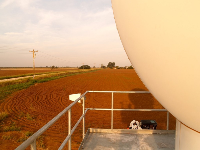
Soil dusts disperse into the atmosphere when farmland is tilled or harvested or when eroded farm soils are swept around by winds. The resulting airborne particles are made of fine bits of plant matter, minerals, microbes, fungi, and bacteria.
To get from farmland into the troposphere (the lowest layer of the atmosphere), such particles require vertical turbulence, which modelers find hard to measure at fine scales. A 2021 study in the Journal of Geophysical Research: Atmospheres demonstrates a new way to accurately simulate this upward motion of air.
Modelers are interested in “how particles, once emitted, might be transported to clouds,” says the study’s lead author, Gavin Cornwell, a postdoctoral researcher at Pacific Northwest National Laboratory (PNNL) in Washington state.
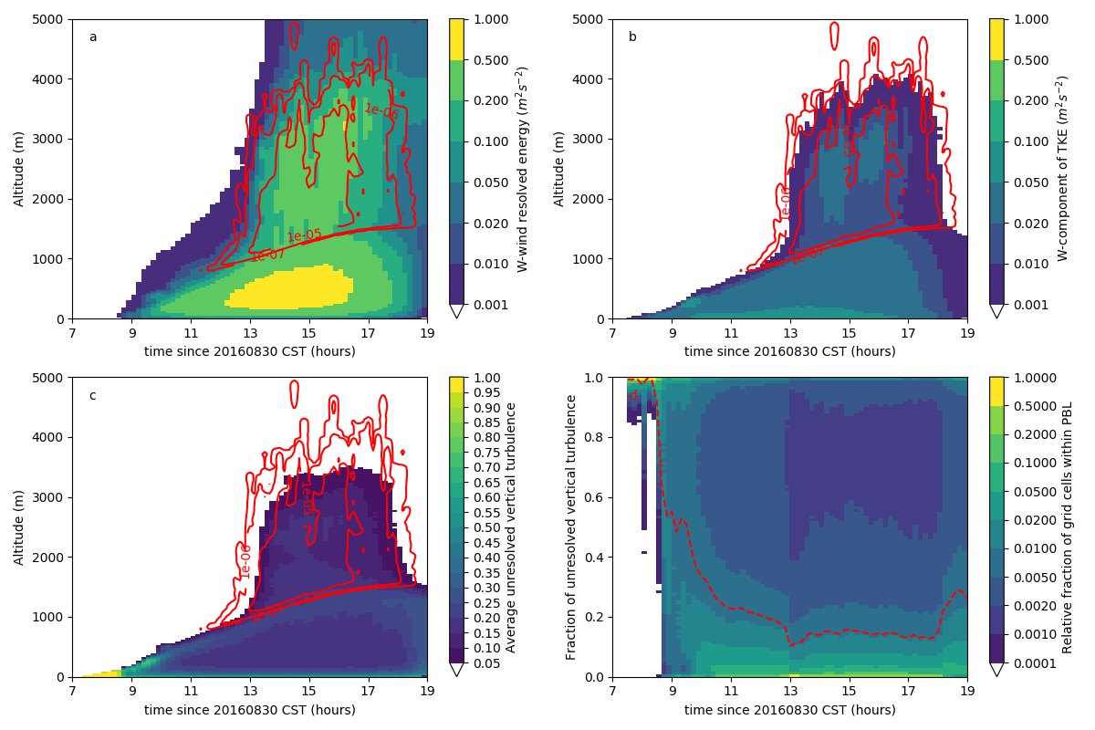
In particular, the new study fills in a gap by simulating dust transport at very fine resolutions, in predictive grids measured in meters instead of kilometers.
“There has not been a lot of work at these higher resolutions,” says Cornwell, “where you start resolving more atmospheric features.”
Looping In LASSO
In farming regions, agricultural dust emissions can modify how long clouds live and how much incoming solar energy they directly absorb.
To have such an influence, soil dusts first have to be mixed vertically upward through the boundary layer, where the Earth’s surface influences how heat, momentum, and moisture mix. Such vertical transport is controlled by turbulence, making it hard to model accurately.
To get around that, Cornwell turned to a modeling tool developed by the U.S. Department of Energy’s (DOE) Atmospheric Radiation Measurement (ARM) user facility. The Large-Eddy Simulation (LES) ARM Symbiotic Simulation and Observation (LASSO) activity is a library of simulations and data bundles that combines ARM observations and high-resolution simulations.
With LASSO, researchers got a horizontal grid resolution of 100 meters (328 feet), fine enough to directly simulate complex moving eddies—or currents—of air. By contrast, most regional models have grids at a scale of around 1 kilometer to 25 kilometers (0.62 miles to 15.5 miles). Even more coarse, global climate models are based on grids with resolutions from tens to hundreds of kilometers.
Convenience matters too.
“LASSO has already run a series of simulations that have been validated against observational data,” says Cornwell.
That means researchers do not go through the burden of setting up a framework for their simulations.
Cornwell described the paper’s researchers as “the exact (right) customer for LASSO. We want to be able to take advantage of that type of research.”
“It is great to see the research community pick up LASSO and use it in ways we never imagined, all to advance our understanding of the atmosphere.”
William Gustafson, LASSO principal investigator
In its first iteration, LASSO formulated cases on shallow cumulus clouds at ARM’s Southern Great Plains (SGP) atmospheric observatory. The Cornwell study, which also includes funding from DOE’s Atmospheric System Research (ASR), used three of those cases.
LASSO developer and PNNL climate modeler William “Bill” Gustafson and others have since expanded LASSO’s focus to deep convective cloud regimes.
Says Gustafson: “It is great to see the research community pick up LASSO and use it in ways we never imagined, all to advance our understanding of the atmosphere.”
Dust and Ice Nucleation
In the past, with good reason, agricultural soil dusts have been deeply investigated for their health impacts on farmworkers, their influence on regional air quality, and the loss of soil nutrients they represent. Dust erosion from farmland may even play a role in the global carbon cycle.
However, the same dusts are only lately being intensively studied regarding how they affect the Earth’s radiation budget. Cornwell and his co-authors believe that no current earth system models include representations of farm-related dusts.
Yet agricultural dusts can modify cloud properties and dynamics by acting as ice-nucleating particles (INPs), which act as seeds for ice crystals. In turn, INPs help create raindrops, determine cloud radiative feedback, and even set the stage for lightning.
By enabling ice to form in clouds (a process called ice nucleation), INPs help determine whether those clouds are frozen or liquid―that is, the “phase” of the clouds.
INPs go on to change a cloud’s microphysical properties. This has major implications for precipitation and how clouds either reflect sunlight, which cools the Earth, or traps heat, which warms the Earth.
Cornwell, who started at PNNL in 2019, works with atmospheric modeler Susannah Burrows, a co-author on the new paper. Her ongoing DOE Early Career Research Program award research is primarily focused on INPs in agricultural and marine settings.
Says Burrows: “We are combining measurements and models to better understand what controls the enormous variations that we see in INP concentrations in the atmosphere.”
A Dispersion Model
With LASSO as a starting place for simulating the vertical transport of agricultural dusts from the SGP, Cornwell and the others used a modified version of the FLEXible PARTicle Weather Research and Forecasting (FLEXPART-WRF) particle dispersion model.
They first focused on alternate treatments of FLEXPART-WRF to select a scheme suitable for LES scales. Then they used a single LASSO simulation to perform sensitivity experiments in FLEXPART-WRF to better understand how particle transport and removal depend on various factors, including density, size, release time, and injection height. To explore the impacts of various meteorological conditions on vertical dust transport, they also used several days from the LASSO ensemble.
FLEXPART-WRF is a Lagrangian particle dispersion model―that is, one intended to simulate the movement and properties of targeted parcels of air. Scientists can choose to follow the dispersion of a number of properties or values, such as turbulence. Lagrangian models work at a variety of scales, and both forward and back in time.
Starting in the 1990s, FLEXPART models have been redeveloped and upgraded many times. They have been used to predict the movement of air parcels following the dispersion of radionuclides, volcanic ash, or some other pollutant.
In atmospheric science, ensembles of Lagrangian air parcels have been widely adapted to model the transport of a specific value or substance, such as humidity, wind speed, particles, or some other well-defined physical property.
In the paper, says Burrows, “Cornwell introduced adaptations of FLEXPART-WRF that more appropriately represent turbulent dust transport.”
To simulate turbulent diffusion, Cornwell and his co-authors deployed a large number of tracers and sent them moving through time and space. They also employed a quasi-single-column model to compare their results with a parameterized treatment of turbulence. (A single-column model encompasses a vertical column over one grid cell in a model from the surface to the top of the atmosphere.)
In all, their results underscored the importance of correctly modeling the role that turbulence plays in vertical particle transport.
Dust Cousins
“Ultimately, we are interested in improving the representation of INPs (ice-nucleating particles) in models.”
Gavin Cornwell, Pacific Northwest National Laboratory
During his PhD work on atmospheric aerosols at the University of California, San Diego, Cornwell mainly researched investigated how dusts can be INPs.
In what he calls the “dust community” of researchers, agricultural dusts have received less attention compared with the abundant mineral dusts swept up from hot, dry places around the world such as deserts and dry lake beds. These dusts, lofted to higher altitudes than their agricultural cousins, are transported through the atmosphere in vastly greater quantities.
“Total global dust burden is quite firmly controlled by mineral dusts,” says Cornwell, and not by lesser and more regionally dispersed agricultural dusts.
Yet for more than a decade, research has shown that agricultural soils seem to be more efficient INPs than their mineral counterparts. Dusts from deserts and agricultural regions both contain mineral components, but agricultural dusts have a more complex composition that includes organic and biological materials. They are also more likely to initiate ice nucleation at warmer temperatures, and thus at lower elevations in clouds.
Why farm soils make better sources of INPs is a puzzle that still needs solving, says Cornwell, though the answer, so far, “is thought to be biological.”
His paper on simulated dust transport in the boundary layer can be viewed as an incremental step toward a larger interest.
“Ultimately,” says Cornwell, “we are interested in improving the representation of INPs in models.”
How Many INPs Reach Clouds?
To create INPs (or to have any other effects on clouds), agricultural dusts have to be transported into the atmosphere high enough to where clouds reside. That means modeling the turbulent vertical transport of particles at fine resolutions is an important contribution to the literature.
The Cornwell et al. paper is also a reminder that reaching cloud altitudes at all can be quite an accomplishment for a particle of leaf or fungus or bacteria.
A lot of what the wind sweeps into the air falls back to Earth or gets caught on vegetation or another surface―a process known as dry deposition.
Or a wind-swept particle gets beaten back to the surface by rain: wet deposition.
Particle size and density are factors too because they control what Cornwell calls a particle’s “aerodynamic diameter.”
On the way skyward, “there are definitely a lot of opportunities (for a particle) to be lost,” he says.
In the end, only a few particles get injected high enough, and at the right time, to enter a cloud in such a way that they enable freezing (and therefore become atmospherically consequential). The exact number of agricultural dust particles that enter clouds under different atmospheric conditions has been difficult to quantify.
“How many make it up there?” asks Cornwell. “It would be awesome to find out.”
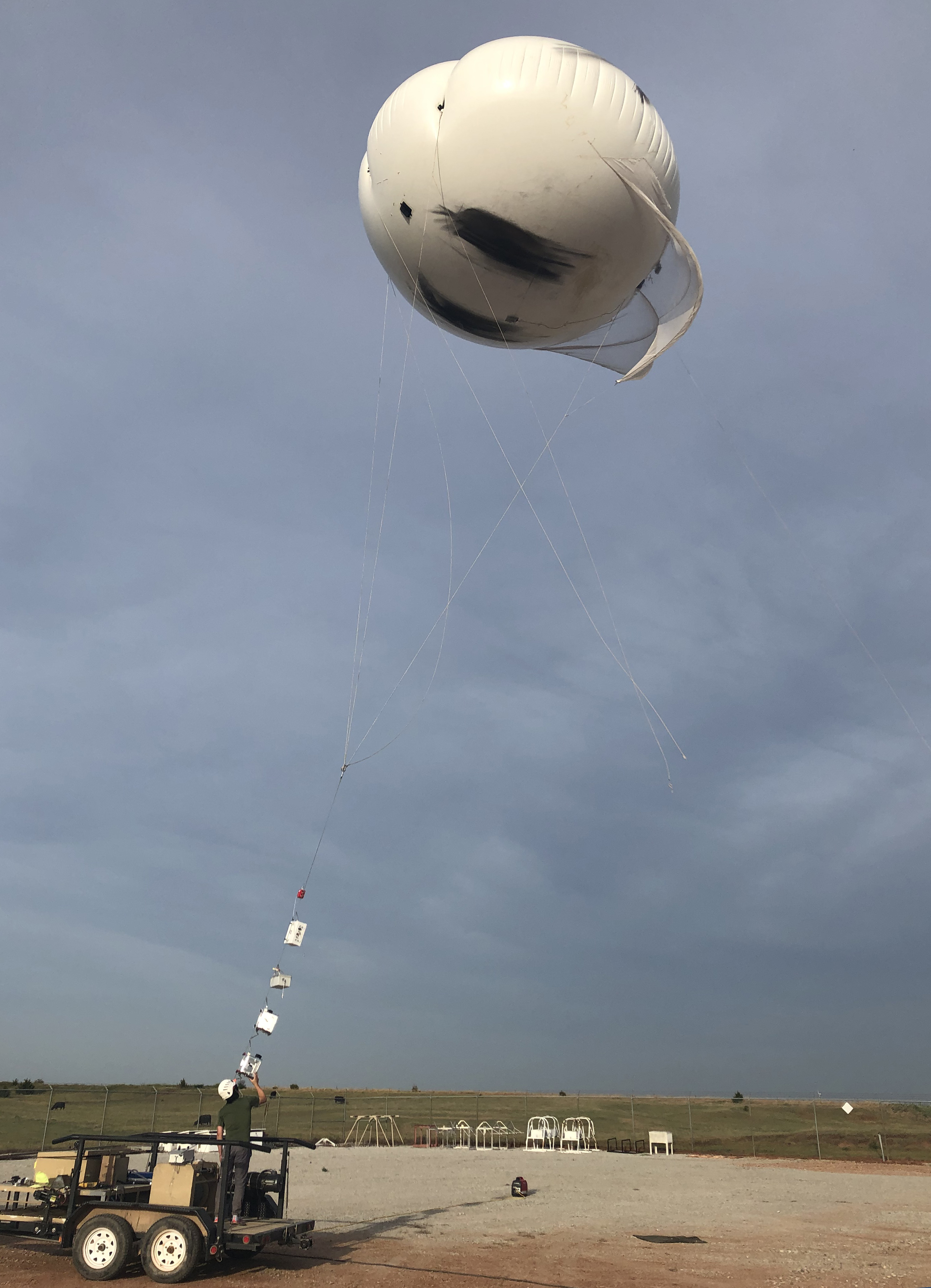
The Promise of Tethered Balloons
Cornwell points out that “generally speaking, it’s really difficult to measure aerosols aloft,” and that obtaining such measurements requires crewed aircraft, uncrewed aerial systems, or tethered balloon systems (TBS).
It is the last possibility that excites Cornwell the most because TBS “can be parked in one location and at one altitude―a capability you’re starting to see more research groups deploy globally.”
Paired with the right particle counter and other aerosol instrumentation, he says, TBS promise fruitful data. ARM has already made advances in that direction by linking PNNL atmospheric scientists, such as Burrows, with instrument-miniaturization specialists.
One is Swarup China, an aerosol chemist at the Environmental Molecular Sciences Laboratory (EMSL), a DOE Office of Science user facility located on the PNNL campus. He has already collaborated with ARM on TBS launches of his briefcase-size automated aerosol collector.
In the spring of 2022, Cornwell will join Burrows and other scientists in a field study near the SGP. For starters, they will measure INP properties and composition during tilling season, when agricultural dusts sift abundantly into the air.
The Burrows group will use only ground instruments, he says, and even do some offline INP calculations. But promisingly, the work will overlap with at least one TBS deployment.
“Combining the ground-based measurements with vertical profiles and sampling during different seasons,” says Burrows, “will give us a much better overall picture of where these particles come from and how much they may impact clouds.”
Follow Us:


Keep up with the Atmospheric Observer
Updates on ARM news, events, and opportunities delivered to your inbox
ARM User Profile
ARM welcomes users from all institutions and nations. A free ARM user account is needed to access ARM data.


