

Chasing Down the Science of Thunderstorms
Published: 22 January 2019
Dual campaigns are underway in Argentina, where the largest convective storms in the world gather and grow
The video describes the work being done during ARM’s Cloud, Aerosol, and Complex Terrain Interactions (CACTI) field campaign in the Sierras de Córdoba mountain range of north-central Argentina. CACTI is designed to improve understanding of cloud life cycle and organization in relation to environmental conditions so that cumulus, microphysics, and aerosol parameterizations in multiscale models can be improved.
A U.S. Department of Energy (DOE) field campaign called CACTI—Cloud, Aerosol, and Complex Terrain Interactions—is aptly named for its prickly science mission: to learn more about large regional convective storms, including their life cycle—how they form, grow, and organize.
Such storms contribute most of the rainfall in many regions of the world. Yet to date, a fine-tuned sense of how they work remains absent, which results in poor representations of them in earth systems models.
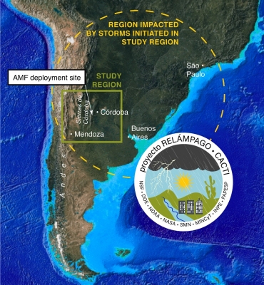
CACTI, which began in October 2018 and will run through April 2019, will help close current knowledge gaps when an international team of as many as 150 scientists will gather off and on at the birthplace of the largest thunderstorms in the world: the Sierras de Córdoba mountain range in north-central Argentina.
The seven-month effort happens from fall through spring. It is during this wet season that the normally arid region east of the Andes receives nearly all of its rainfall—about 700 millimeters (27.5 inches).
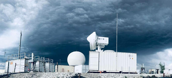
Much of the data will stream into open-source archives thanks to DOE’s Atmospheric Radiation Measurement (ARM) user facility, which is providing CACTI’s main eyes on the sky, a multi-instrument portable platform called the ARM Mobile Facility (AMF).
ARM’s C-band scanning precipitation radar is being deployed for the first time. Along with more than 50 other instruments, it will sample environmental properties in and around growing clouds that become thunderstorms—including measurements of aerosols, clouds, and precipitation.
The Right Site
ARM’s first AMF, known as AMF1, will be set up near Villa Yacanto, an Argentine village of a thousand residents about 20 kilometers (12 miles) east of the highest ridge top in the Sierras de Córdoba mountain range.
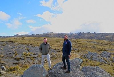
With an elevation of 1,150 meters (about 3,800 feet), and right within the complex orographic terrain that focuses development of the big storms, the site is “ideally situated” to observe how these storms initiate, grow, and organize, says CACTI principal investigator Adam Varble, an atmospheric analyst and modeler at Pacific Northwest National Laboratory.
These processes will take place virtually overhead, he says, sketching out the unique terrain and where the CACTI observations location fits on it. Uphill flows of air converge into convective clouds just west of the site, then grow over and past the site to the east.
AMF1 radars will strategically scan cumulus clouds, early-stage isolated deep convection, and later-stage organized convective cloud systems within the vicinity of Villa Yacanto.
At the AMF1 site and to the west of the Sierras de Córdoba ridge top, radiosondes will be launched every two to six hours to gather data on atmospheric properties.
In order to “tease out environmental conditions that are important,” says Varble of studying deep convective initiation and growth, “you need a site where it happens frequently with range of measurements.”
From October 30 to December 13, 2018, ARM’s Gulfstream-159 (G-1) research aircraft will supplement data from CACTI ground instrumentation. Staged at Las Higueras Airport in Rio Cuarto, a two-hour drive away from AMF1, the aircraft will fly transects at multiple altitudes upstream (west), downstream (east), and through developing cumulus clouds.
Instruments aboard the G-1 during its orographic cumulus flights will primarily take in data on in-cloud dynamics, microphysics, aerosols, and environmental variables around clouds near the site.
“It counts a lot,” says Varble of what the G-1 adds to CACTI, including data on the shapes and weight and water-ice content of cloud particles and the “cold pools”: convective downdrafts generated at lower altitudes.
Safety, however, comes first, he adds. No one in the G-1 will be flying through thunderstorms.
A Living Lab for Thunderstorms
Varble scouted the Villa Yacanto site with Stephen Nesbitt of the University of Illinois, one of 17 U.S. and Argentine CACTI co-investigators. Both earned their PhD at the University of Utah—Varble about a decade after Nesbitt.
Nesbitt is also the principal U.S. investigator for an Argentine-led campaign that is concurrent with CACTI, though it is shorter in duration. RELAMPAGO, an acronym that means “lightning flash” in both Spanish and Portuguese, stands for Remote sensing of Electrification, Lightning, And Mesoscale/microscale Processes with Adaptive Ground Observations.
It will focus on high-impact weather in the lee of the Andes Mountains, with an eye toward improving forecasts of severe weather systems. Funded largely by the National Science Foundation (NSF) and with support from NASA, RELAMPAGO will involve about 15 Argentine researchers. The science lead for Argentina is veteran researcher Paola Salio of the University of Buenos Aires.
Weather agencies and universities in Argentina and Brazil are also contributing money and resources.
With a series of truck-mounted radars emplaced to measure storms, RELAMPAGO researchers will track large hail, strong winds, and heavy precipitation.
One ultimate goal is to assist Argentina’s meteorologists. Nationwide, there are only 25 within the Argentinian national weather service. Their ability to accurately forecast early warnings for severe weather is hampered by the large region they have to cover, technological obstacles, and limited observations.
Knowledge gained from the campaign will hopefully improve weather prediction and will therefore benefit Argentina’s civil society.
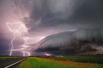
Severe thunderstorms are among the atmosphere’s most destructive phenomena. They can produce hail, high winds, hundreds of lightning strikes per minute, and—in some cases—tornadoes.
On the ground, such storms can flood rivers and roadways, damage crops, and produce baseball-size hail that (if heavy enough) rocket to the ground at 60 mph.
In all, northern Argentina “is a very turbulent, very useful place to be,” says Nesbitt, a storm-savvy native of suburban Buffalo, New York, who not long ago sat for an explanatory RELAMPAGO video.
Helping Nesbitt with campaign logistics is Paloma Borque, a University of Illinois postdoc and McGill University PhD who studied with Salio as an undergraduate.
Borque is a radar expert with experience studying cloud physics and the South American low-level jet stream east of the Andes that transports thunderstorms fueling moisture from the Amazon to Argentina. She looks forward to what she calls “a gold mine of data” that will come out of CACTI-RELAMPAGO.
“In my case,” says Salio of the coming campaigns, “it’s like a dream come true.”
There will be plenty of binational data to analyze, she agrees, and meteorological prediction systems in Argentina may improve.
The dual campaigns may also prompt her government to invest in more radars, says Salio, including more powerful S-band radars and radars in regions where severe storms happen.
Nesbitt hopes for the same thing—“a huge legacy of many radars is to study severe weather.” He also sees the campaigns as a rare opportunity to study how clouds behave and how rainfall is distributed over complex terrain.
CACTI-RELAMPAGO will also deepen science relationships between the two nations, says Salio. “We are on the other side of the world. It is important to have these kinds of ties.”
For CACTI, the most intensive data gathering will take place from October 30 to December 13, 2018, a period that coincides with the peak of austral spring and—the researchers hope—the most interesting storms: all the better for good data.
By design, RELAMPAGO will take place at nearly the same time as the CACTI intensive period, from November 1 to December 18, 2018.
Salio recalled being with Nesbitt during a 2012 campaign to observe thunderstorms in southern Brazil.
“We started to think the storms in central Argentina were more interesting. It was too sunny. We had beautiful days, but this is not what we like,” she says. “This was the moment RELAMPAGO was born.”
Hail, High Winds, and Floods
In the case of CACTI and RELAMPAGO, what Salio and other scientists like are places where severe weather happens.
Thunderstorms are familiar to all because of their heavy rainfall and lightning. Such storms are technically “severe” if they pack straight-line winds over 58 mph and drop hail that is at least 1 inch in diameter.
In the United States, about 15,000 severe storm and tornado warnings are issued every year by the National Weather Service. Some of them are tracked by instruments at ARM’s Southern Great Plains (SGP) atmospheric observatory.
SGP instrumentation covers 9,000 square miles of flat rural terrain in Oklahoma and Kansas, a region where the most epic U.S. thunderstorms take place.
The CACTI site in Argentina is different from the SGP in that it is located where many storms initiate and begin growing—processes that will be targeted by measurements.
To date, Argentine storms are poorly measured relative to their U.S. counterparts, says Varble. They also display larger cloud shields, longer duration, more rainfall, and deeper convection than the most extreme SGP storms—for yet-unknown reasons.
A landmark 2006 paper by University of Utah scientist Edward Zipser and others established that this region of northern Argentina, east of the Andean cordillera, produces the most extreme convective systems in the world.
One reason that CACTI and RELAMPAGO are happening at all was a connection that Varble, Nesbitt, and Salio all share: Each has studied with Zipser at the University of Utah (Salio as a postdoctoral fellow).
Each considers him a mentor, says Varble. “He passed on his love of field experiments.”
In 2006, Zipser’s conclusion that northern Argentina was Thunderstorm Central was based on satellite snapshots that highlighted the depth and internal structure of some of the storms.
Among other satellite-data proxies modelers use to define intense convection are wind gusts, large hail, lightning flash rates that can exceed 300 per minute, and—perhaps most important of all—the magnitude of updrafts (convective vertical velocities) that penetrate into the stratosphere.
The Zipser paper described one “champion thunderstorm” that took place in northern Argentina on December 30, 1997. Its cloud top reached temperatures colder than minus 110 degrees Celsius. Radar echoes indicated the presence of large, dense ice particles at an altitude of 19.5 kilometers (more than 12 miles).
The storm was taller than any others in the study, which looked at more than 13 million precipitating events from 1998 to 2004. As of 2018, says Varble, “it remains the champion storm measured by space-borne radar.”
It is clear to Zipser (and now to most of those in atmospheric science) that north-central Argentina is the place to be for atmospheric scientists who call themselves cazadores de tormentas: in Spanish, “storm chasers.”
A Nation of Weather Watchers
Storm chasers or not, RELAMPAGO and CACTI “are not like ‘Twister’,” says Salio in a reference to the 1996 American disaster movie. There is serious science underway.
However, she and Nesbitt both point to a deep-seated culture of weather watchers in Argentina, where an epic hailstorm (for instance) will light up Twitter, Facebook, and YouTube. (RELAMPAGO has its own Twitter feed.)
With a touch of national pride, Salio referred to a February 8, 2018, hail storm in Villa Carlos Paz, Córdoba, that was said to produce the largest hailstone ever recorded in the Southern Hemisphere, a spiky projectile more than 7 inches in diameter.
Extreme weather stories are “always in the newspaper,” says Nesbitt, who in the spring of 2015 moved with his family to Buenos Aires for a university sabbatical and to polish up his Spanish.
“They’re intense, they’re scary,” he said of hail storms in the region. “Definitely a force to be reckoned with.”
Salio has watched hail clatter into Buenos Aires, denting cars.
Borque, the Illinois postdoc, appreciates severe storms. “You realize that is what you are trying to understand.”
She remembers one in 2006, when she was still in Buenos Aires. “You are in a snowfield,” says Borque. “But the snow was hail.”
In a nod to the importance of social media to storm watchers in Argentina, Varble says the first order of business upon arriving will be to reach out to the Argentine public about the science that is being done.
He will also write a CACTI blog.
Storm chasers, stay tuned.
Follow Us:


Keep up with the Atmospheric Observer
Updates on ARM news, events, and opportunities delivered to your inbox
ARM User Profile
ARM welcomes users from all institutions and nations. A free ARM user account is needed to access ARM data.


