
POPEYE Could Offer New Insights on Atmospheric Processes in the Arctic
Published: 19 June 2018
Campaign is part of large international effort to improve modeling capabilities around the poles
The Atmospheric Radiation Measurement (ARM) user facility is preparing for a heavy flight schedule of unmanned aerial systems (UAS) this summer and fall at its Oliktok Point site in northern Alaska.
The flights are part of a field campaign called Profiling at Oliktok Point to Enhance YOPP Experiments (POPEYE). It is associated with the Year of Polar Prediction (YOPP), a large international effort taking place from mid-2017 to mid-2019. YOPP seeks to collect atmospheric observations that will help improve modeling and forecasting capabilities around both poles.
POPEYE, which will run from July 1 to September 30, coincides with the second special observing period of YOPP. These periods represent concentrated efforts to provide as much observational information as possible on the arctic environment.
At Oliktok Point, where the U.S. Department of Energy (DOE) controls restricted airspace supporting ARM’s UAS efforts, campaigns have usually consisted of several measurement periods lasting a few weeks at a time, and often over a couple of years.
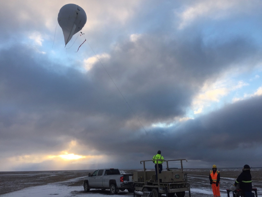
POPEYE is a different kind of undertaking. Tethered balloons and DataHawk UAS will operate continuously, with the two teams alternating in two-week shifts over the three-month POPEYE period.
“This is definitely the most condensed, intense period where something’s going to be flying all the time,” says Dari Dexheimer, a Sandia National Laboratories atmospheric scientist who is coordinating the tethered balloon efforts in conjunction with a team from Pacific Northwest National Laboratory.
The Influence of Light and Darkness
When POPEYE starts, Oliktok Point will be under 24-hour daylight. During summer in the Arctic, this sunlight can drive a convective boundary layer over land in which the formation of eddies generates turbulence and clouds—sometimes even a thunderstorm.
“That’s becoming more common in some ways in the Arctic,” says POPEYE principal investigator Gijs de Boer, a research scientist at the Cooperative Institute for Research in Environmental Sciences at the University of Colorado, Boulder. “As we get more open water and we get warmer conditions, we start to see things like thunderstorms in the Arctic, which generally haven’t occurred very frequently.”

As fall approaches, a temperature gradient begins to build over the water. “You can have cold air coming off of the sea ice pack, which is still offshore, blowing over that warmer water surface and generating convection there,” says de Boer, the DOE Atmospheric System Research science lead for ARM’s efforts at Oliktok Point. “And the land starts cooling off as well through the month of September, so you see this really stark evolution from what is really close-to-shore ice in the beginning of July to open water offshore and then the ice coming back as you get toward October.”
In late September, when POPEYE concludes, the sun will rise around 8 a.m. and set around 7:30 p.m. De Boer says the POPEYE team hopes to see stable boundary layers—warm air sitting on top of cold air—as the dark hours start to return. These layers and the limited turbulence within them have historically been difficult for models to represent.
Probing the Clouds
In July and August, most clouds seen at Oliktok Point are small, puffy, and largely made up of liquid water. Deeper into fall, stratiform (layered) clouds with more ice in them become prevalent.
Tethered balloons, which operate up to 1.5 kilometers (0.93 miles) above Oliktok Point, will be used during POPEYE to gather in situ data from within and above the clouds. In addition to collecting data on temperature and humidity, tethered balloons will be equipped with aerosol instruments, such as optical particle spectrometers and a condensation particle counter, “so we get profiles of the aerosol structure vertically and we can start to see how different sources of particles might impact the clouds at any given time,” says de Boer.
Aerosols could come from a variety of areas, including the nearby oil fields, Alaskan forest fires, or the ocean.
A DataHawk team from Pacific Northwest National Laboratory will fly the UAS between the surface and the clouds to measure temperature, humidity, and winds. The transfer of heat and energy will be derived from these measurements as well.
“DataHawk measurements will provide more spatial coverage and profiles of atmospheric properties in the boundary layer,” says Fan Mei, the ARM Aerial Facility’s director of science.
Data from an ARM Mobile Facility deployed at Oliktok Point—part of ARM’s North Slope of Alaska atmospheric observatory—will supplement the UAS measurements and provide much-needed broader context.
In May, the monthlong Aerosol Vertical Profiling at Oliktok Point field campaign included some instrument and balloon preparation for POPEYE.
A Unique Environment

The POPEYE team expects to encounter the infamously harsh winds that often blow along the North Slope. Tethered balloons and DataHawks tend to be grounded if the sustained winds get much above 20 miles per hour. The DataHawks are “powered by relatively small electric motors, so if the winds are too high, they’re actually flying backwards,” says North Slope of Alaska Facility Manager Mark Ivey, who works at Sandia.
With more sunlight available in the summer, some flights might take place much later than usual if winds cooperate.
“I think we’re going to activate the airspace 24/7, so yeah, that could happen,” says Dexheimer.
The two-week intervals away from Oliktok Point will help give the tethered balloon and DataHawk teams opportunities to replenish their resources and gear up again for the challenges of working in such a remote area. Many oil field workers also have a schedule of two weeks on, two weeks off.
With a lack of weather radars north of Fairbanks (about 600 miles from Oliktok Point), forecasting activities in northern Alaska are informed by satellites, weather balloon data, and sea ice and ocean measurements. POPEYE and YOPP could be critical in providing insight into the types of data that are essential for better forecasts for residents, as well as for industries that are vital to the Alaskan and global economies.
“There’s a significant stakeholder community in northern Alaska that can benefit from improved models and forecasts for that region,” says de Boer, “both on short and long timescales.”
The ARM Climate Research Facility is a DOE Office of Science user facility. The ARM Facility is operated by nine DOE national laboratories.
Follow Us:


Keep up with the Atmospheric Observer
Updates on ARM news, events, and opportunities delivered to your inbox
ARM User Profile
ARM welcomes users from all institutions and nations. A free ARM user account is needed to access ARM data.


