

LASIC Data Reveal Smoke Aerosol Presence Higher Than Previously Believed
Published: 15 April 2018
Particles Causing Atmospheric Changes Are Common in Mid-Atlantic Boundary Layer
Researchers recently completed the first study to gather comprehensive, daily data with ground-based instruments on the properties of prolific smoke crossing the Atlantic from biomass fires in Africa within a remote cloudy trade-wind regime.
New data from the Layered Atlantic Smoke Interactions with Clouds (LASIC) field campaign, conducted by the ARM Climate Research Facility, reveal that high amounts of aerosols (tiny particles in the air) that can affect the Earth’s energy balance and cloud properties are common in the marine boundary layer during the African burning season (June-October).
ARM, a U.S. Department of Energy national scientific user facility, launched LASIC in June 2016 to gather data on how smoke properties (e.g., ability to absorb shortwave radiation) change after long-range atmospheric transport, as well as the smoke’s effect on clouds. The campaign captured data from two biomass-burning seasons over a 17-month span that reflected repeatable trends across two summers.
Data were obtained at the latitude zone for maximum aerosol outflow: Ascension Island, in the middle of the South Atlantic Ocean. Winds carry smoke over one of Earth’s largest stratocumulus cloud decks, with the clouds transitioning to shallow cumulus at Ascension.
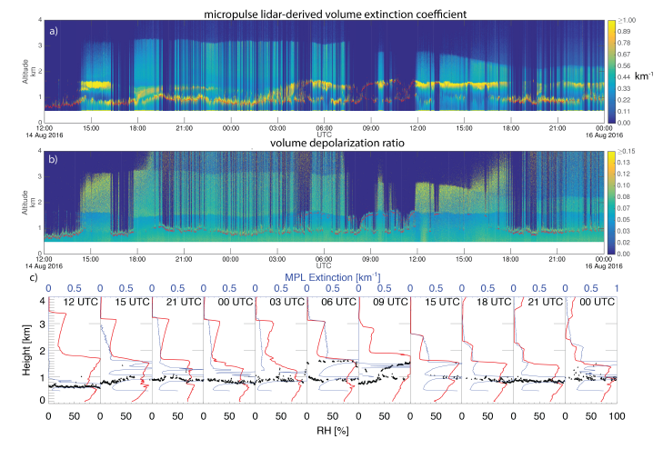
Early measurements showed that one type of light-absorbing smoke aerosol was present over Ascension Island approximately 94 percent of the time—at times in extremely high concentrations.
Concentrations of this smoke aerosol, light absorption coefficients, and cloud condensation nuclei concentrations varied and peaked in August. Smoke was more predominantly present in the boundary layer early in the biomass-burning season and more likely in the lower troposphere in autumn, when it typically rested on the cloud-top inversion. The most light absorption occurred in June, and the single-scattering albedo appeared to increase from August to October.
“We were surprised by the high levels of smoke and the unique composition,” says Paquita Zuidema, LASIC principal investigator and a professor at the University of Miami. “There is clear evidence of drizzle suppression from smoke in certain cloud types. I think we’re in store for more surprising results.”
Long-Distance Discoveries
Southern Africa releases smoke particles from primarily agricultural burning (e.g., wood and grasses) that can travel as far west as Brazil. Smoke particles can either warm or cool the planet, depending on how much sunlight they absorb and whether or not the smoke is above a reflective low cloud deck. Many aspects of this large subtropical aerosol-cloud system remain poorly understood, and modeling and predicting how smoke affects atmospheric processes needs to be improved.
Understanding the cloud response to smoke—in particular, whether and how the presence of smoke strengthens or weakens the low cloud deck that independently cools the atmosphere—requires data not previously available from this region.
LASIC data help characterize the myriad absorbing aerosol-cloud radiation interactions and will help constrain modeling studies capable of testing specific processes. Before LASIC, satellite studies, modeling simulations, and a few widely separated sunphotometers provided the most data about the aerosol-cloud interactions in this region.
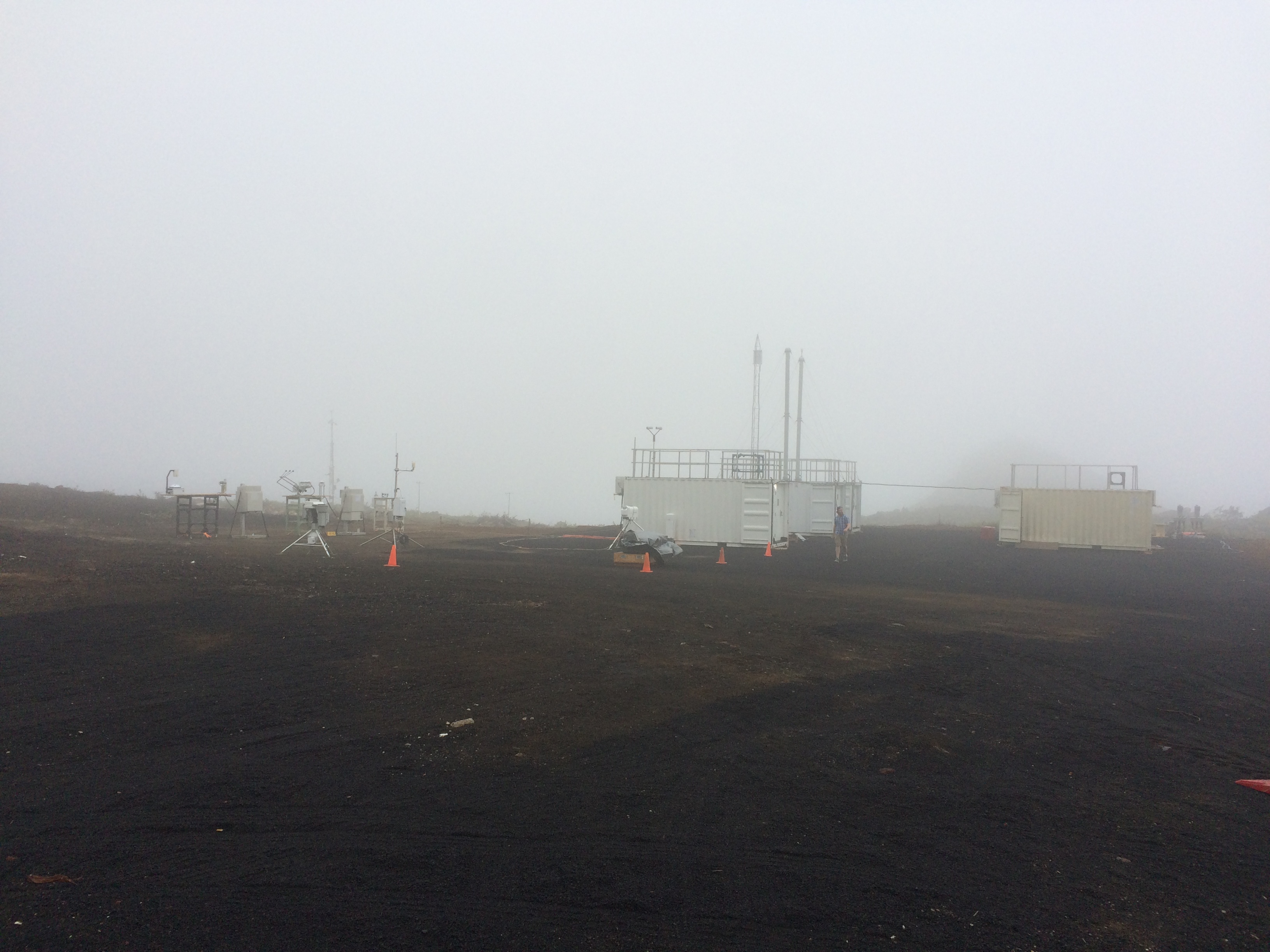
An ARM team based out of Los Alamos National Laboratory deployed and managed the first ARM Mobile Facility (AMF1), a portable observatory containing some of the most advanced atmospheric research instruments. These include a suite of in situ and remote aerosol and cloud sensors, including a scanning radar and a lidar able to fully profile the aerosol vertical structure between the clouds. Radiosondes released four to eight times a day captured the first characterization of the diurnal cycle with and without smoke present—a useful test for smoke-cloud process hypotheses.
LASIC researchers included scientists from the United States, United Kingdom, and France. Important data contributions also came from a U.K. aircraft-based research campaign on Ascension in 2017 and NASA aircraft sampling in Namibia and the Gulf of Guinea in 2016 and 2017, allowing LASIC results to be extrapolated vertically and establishing a spatial context. The LASIC findings, in turn, provide a seasonal context to the shorter-term aircraft campaigns.
Researchers said that the omnipresence of smoke over Ascension Island was especially remarkable because the African source was 1,700 kilometers away.
“Preliminary analysis of the aerosol data from the Aerosol Observing System during LASIC shows significant increases in the aerosol mass concentration in the boundary layer during the South African biomass-burning season,” says Allison Aiken, Los Alamos atmospheric scientist, LASIC collaborator, and ARM’s Mobile Aerosol Observing System manager. “The chemical composition of the biomass-burning aerosols also looks quite different from what we’ve observed over the continental U.S. and during other campaigns.”
Facing—and Overcoming—Logistical Challenges
Ascension Island provided unique challenges to ARM, primarily due to the remoteness of the mid-Atlantic island.
“The LASIC data return is fantastic, especially when you consider the logistical hurdles involved, and the data will be mineable for a long time,” says Zuidema.
Personnel travel and the shipping of infrastructure and instruments to and from Ascension was only available by infrequent military services. The Los Alamos team expertly coordinated the circuitous transport of AMF1 equipment from the previous deployment site in Brazil’s Amazon jungle to Ascension Island.
“Getting items from Brazil, known for import/export challenges, and transporting equipment and personnel to Ascension was a massive challenge,” says Amon Haruta, LASIC logistical manager from Los Alamos. “LASIC comprised the most complex logistics I’ve seen in my 20 years with ARM.”
Ascension Island is one of the most isolated populated locations on the planet. The Los Alamos team staffed the AMF1 with more on-site technicians to ensure that operators could leave the island on occasion while keeping the facility monitored and maintained as data were collected 24 hours per day. Still, travel difficulties arose, exacerbating the sense of isolation. A runway closure meant that a two-week ship voyage was the only way to travel on and off the island.
Vagner Castro, Bruno Cunha, and Juarez Viegas staffed the site the entire length of the deployment, which ended in November 2017.
“The staff and their partners managed it admirably,” says Haruta. “They had a wonderful attitude and integrated themselves into the community. This was one of the best-managed ARM sites, and this was an extremely disciplined operation.”
Haruta credited Los Alamos’ Maciej Ryczek, the LASIC mobile facility operations lead, with remarkable leadership and a supportive relationship with the local government.
“The success of the deployment reflects on a highly dedicated local logistics team as well as diligent instrument mentors,” says Zuidema.
Zuidema and collaborators from the University of Miami and Brookhaven, Los Alamos, Pacific Northwest, and Argonne national laboratories wrote a paper about their LASIC findings that has been accepted by Geophysical Research Letters.
“We are looking forward to delving into the data further to better understand how the boundary layer aerosol relates to the free tropospheric aerosol and what information we can discern about cloud processing from the LASIC data set,” adds Zuidema. “We’ve barely begun to tap the data sets, and I think the most significant findings are ahead of us.”
The ARM Climate Research Facility is a DOE Office of Science user facility. The ARM Facility is operated by nine DOE national laboratories.
Follow Us:


Keep up with the Atmospheric Observer
Updates on ARM news, events, and opportunities delivered to your inbox
ARM User Profile
ARM welcomes users from all institutions and nations. A free ARM user account is needed to access ARM data.


