

From STORMVEX, Novel and Deep Correlative Data Sets on Cloud Properties
Published: 19 March 2017
Linking radiosondes, planes, and mountainside instruments to study winter clouds
It is rarely a good idea to tell a scientist she has her head in the clouds. But Anna Gannet Hallar, an atmospheric scientist who specializes in aerosol and cloud microphysics, thinks that is a lovely idea.

She directs the Storm Peak Laboratory (SPL), a Rocky Mountains satellite of the Nevada-based Desert Research Institute, or DRI. Hallar was among the dozens of scientists, students, and citizen-science volunteers who took part in a five-month study of mountaintop clouds in Colorado’s Park Range during the winter of 2010-2011. STORMVEX, the Storm Peak Lab Cloud Property Validation Experiment, will be spinning reams of golden data for years on cloud and precipitation patterns in mountainous winter terrain. Hallar called the campaign’s multi-instrument data sets “unprecedented.”
Those sets included data from cloud radar scans taken more frequently than ever before, says STORMVEX lead scientist Gerald “Jay” Mace, as well as first-time looks at radar backscatter during certain types of snowfall.
“We’re still learning, and a lot of the analysis we had planned is still emerging,” says the University of Utah atmospheric scientist six years after the experiment closed. “We’re on the verge of really amazing stuff.”
Hallar and Mace are among the hundreds of climate-related scientists worldwide who use data from the U.S. Department of Energy’s (DOE’s) multi-decadal Atmospheric Radiation Measurement (ARM) Climate Research Facility. A recent search showed that STORMVEX data alone, to date, is linked to at least 11 journal articles, four reports, and three theses.
The most recent published research, from February 2017, used STORMVEX data to track how North American aerosol properties are influenced by the trans-Pacific transport of African and Asian dust.
A 2016 report investigated cloud condensation nuclei (CCN) and the composition and size of associated particles. The authors took advantage of a high-elevation STORMVEX research site to investigate the properties of particles that form ice and mixed-phase clouds. They are less studied than warm clouds, even though they dominate precipitation formation globally.
Another STORMVEX paper, from 2015, investigated the impact of blowing snow on precipitation, a phenomenon that has not been studied extensively. Small fractured snow particles, they found, may act as a cloud-seeding mechanism that enhances snow growth.
Hallar co-authored a related 2013 study, which took a detailed look at single particle composition and changes in CCN activation over four days. Researchers recorded dominant sulfate-containing particles, along with those associated with biomass burning, sea salt, and organics.
STORMVEX was possible because of data from an ARM Mobile Facility and because of support from DOE, the National Science Foundation, agency and university collaborators, and the Steamboat Ski and Resort Corporation.
“People were very excited in town. They like weather,” says Hallar of how residents of Steamboat Springs (on the southwestern flank of the Park Range) took in the experiment’s anomalous arrays of observation gear. The local paper added some below-freezing love by publishing a gallery of photos.
Hallar and Mace first conceived of this chilly experiment in July 2006, during a brutally hot NASA aircraft field campaign in Georgia. (With them was DRI scientist Ian McCubbin.) Four other researchers later joined the STORMVEX science team: Sergey Matrosov and Matthew Shupe, both of University of Colorado; Roger Marchand, University of Washington; and Art Sedlacek, Brookhaven National Laboratory.
Skiing to Work
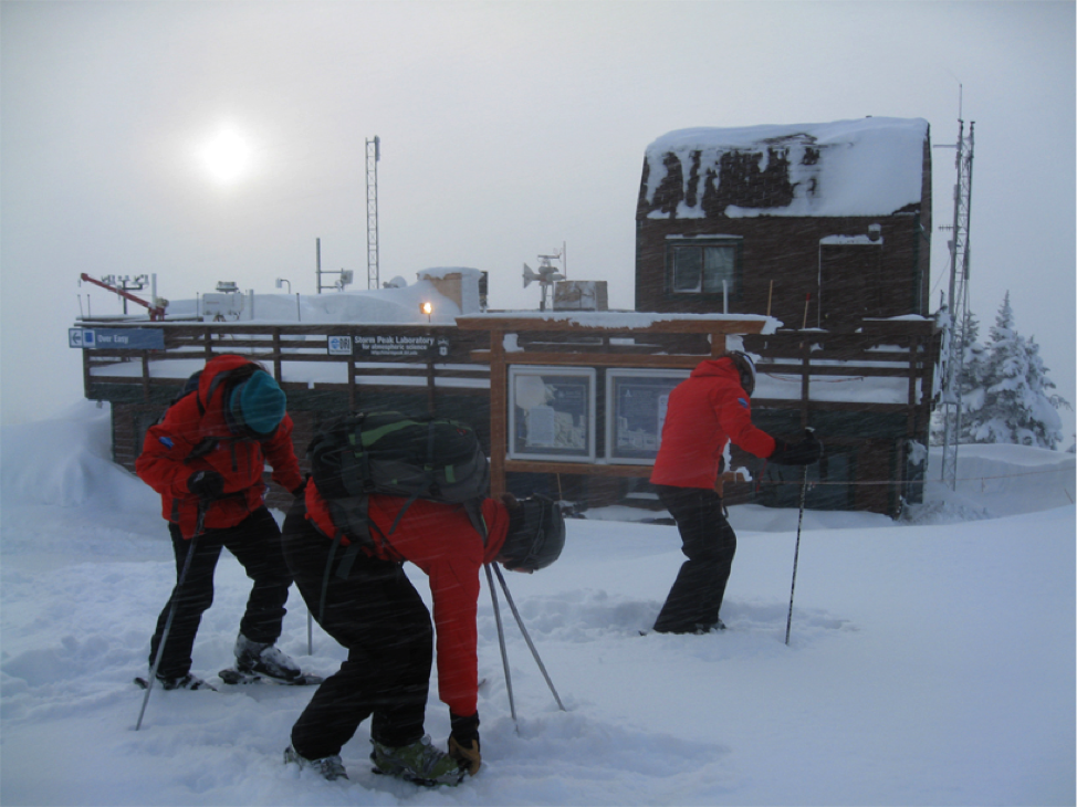
From November to March that year, during the five data-gathering winter months of STORMVEX, about 500 inches of snow fell, an unusually heavy amount. Hallar skied to work at SPL with Mace and other researchers, all clad in black and red snow outfits, helmets, and heavy gloves.
Storm Peak Lab is perched atop Mount Werner at a lung-squeezing altitude of 3.2 kilometers (10,500 feet), and for more than 30 years has been a research site (at first informally) in mountainously remote Steamboat Springs, Colorado, a town of 12,000 just to the west. During the experiment, SPL was the highest-altitude instrument site; three others were on the mountainside and in Steamboat Springs on the valley floor.
From a plane-mounted camera that winter, SPL looked like a snow castle wrapped in clouds. During STORMVEX, says Hallar, conditions were very lucky for cloud scientists: 65 percent of the days were cloudy, close to three times the local winter average. That made Mount Werner an ideal place to study those mutable masses of water and ice that have such powerful effects on weather and climate.
STORMVEX set out to measure the properties of liquid, mixed-phase, and precipitation clouds. Data are intended to improve the way they are represented in computer simulations of the Earth’s climate system. Luckily for those models, says Hallar, a wide range of cloud types appeared during the experiment—thin clouds, thick storm-system clouds, and hard-to-measure mixed-phase clouds, which are part ice and part water.
At Different Heights, a String of Sites
By design, STORMVEX gathered multiple layers of data from multiple altitudes. Some data came from an airborne platform, but ground-based instruments predominated. The standard instruments at SPL (including torpedo-like cloud probes) were cross-validated with other measurement sources: about two dozen instruments at three different altitudes, all in search of a rare vertical profile of clouds as they skimmed above and through mountain terrain. The grand aim was to collect a large correlative data set on wintertime clouds and precipitation in a mountainous setting.
Most correlative data on cloud properties require expensive airborne measurements linked to ground-based data. But penny-pinching STORMVEX was able to gather data equivalent to as many as 400 flights through clouds, says Mace. STORMVEX collected 400 hours of data, which Hallar says is equivalent to “10 air campaigns.”
Some instruments were aboard a University of Wyoming research plane, which flew layered patterns 2,000 feet and more above the mountains. The 29 flights (for 98 hours in the air) were coordinated with ground-based instruments, but created a separate datastream.
Still, it contributed to the lineup of publications related to STORMVEX. One master’s thesis used data from both STORMVEX and the Colorado Airborne Mixed-Phase Cloud Study to compare airborne and mountaintop cloud microphysics. The author found that both sets of data were consistent in matters of snow growth processes and on how terrain flow affected cloud formation.
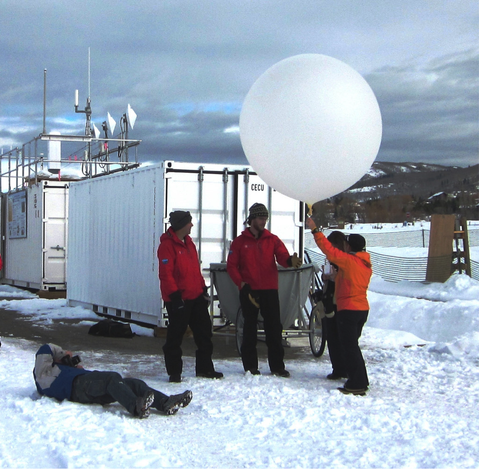
At Thunderhead Lodge, a ski resort 2,760 meters (9,065 feet) up, the ARM Facility deployed part of its second ARM Mobile Facility (AMF2), a portable instrument cluster that includes devices for observing aerosols, profiling the atmosphere, and characterizing clouds. There are three mobile facilities, each one usually deployed for about a year in campaigns all over the world. More AMF2 gear was stacked on snow-white ARM shipping containers at Christie Peak, a ski gondola point 2,103 meters (6,900 feet) up Mount Werner.
Moving valuable and sometimes very heavy instruments to rugged mountain sites was not easy, says Hallar. It often took serial trips by Snow-Cat, gondola, and snowmobile.
On the valley floor, citizen volunteers launched radiosondes eight times a day. These instrumented meteorological balloons, rigged with radio transmitters, rose as much as 100,000 feet into the troposphere. The launch site was near the snug, computer-packed STORMVEX operations hut and data center, where in a newer housing development, power and internet were already in place. Within 24 hours, in near-real time, scientists could view graphical representations of the experiment’s data.
The speed of those daily views belies how climate research works most of the time. “Science really moves very slowly,” says Mace, and good climate data have a long shelf life. “Some of the best field programs I’m aware of from the 1970s are still being published about today.”
STORMVEX data, he adds, have already joined those valuable and long-lived data sets.
# # #
The ARM Climate Research Facility is a national scientific user facility funded through the U.S. Department of Energy’s Office of Science. The ARM Facility is operated by nine Department of Energy national laboratories.
The ARM Climate Research Facility is a DOE Office of Science user facility. The ARM Facility is operated by nine DOE national laboratories, including .
Follow Us:


Keep up with the Atmospheric Observer
Updates on ARM news, events, and opportunities delivered to your inbox
ARM User Profile
ARM welcomes users from all institutions and nations. A free ARM user account is needed to access ARM data.


