

Busy at Bankhead
Published: 27 February 2025
More instruments are going up at ARM’s newest long-term observatory, and science activity is increasing
Since October 2024, the Atmospheric Radiation Measurement (ARM) User Facility has provided data from its Bankhead National Forest (BNF) atmospheric observatory in northern Alabama. Data from new BNF sites and instruments will soon be on the way.
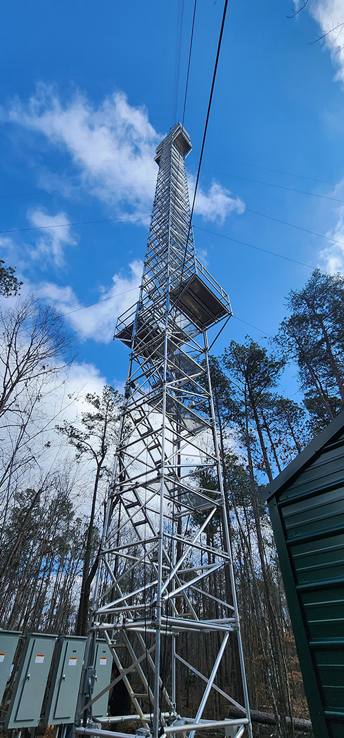
With support from the U.S. Forest Service, which is hosting the BNF, ARM has erected a 140-foot (42.7-meter) tower near the observatory’s main site. Instruments on the tower will sample a variety of properties below, within, and above the forest canopy.
Several instruments are now up on the tower, including multi-level meteorological instrumentation, infrared thermometers, and photosynthetically active radiation sensors. Inlets for some trace gas monitoring and flux measurement systems are also up on the tower. However, the instruments are not yet connected to data communications systems. Meanwhile, infrastructure is being installed for other instruments that will go on the tower.
Final site data system installation for the tower is expected by early March 2025, says BNF Site Technical Operations Specialist Mark Spychala.
Two under-canopy towers near the main site have been assembled, with several instruments installed. Spychala says they will be raised up after the placement of infrared thermometers on the towers is finalized.
Outside the forest, Ka- and X-band scanning ARM cloud radars are currently providing data, while evaluation of data from the second-generation C-Band Scanning ARM Precipitation Radar (CSAPR2) is underway. Data from the CSAPR2 are expected to be available soon.
ARM is also operating three supplemental sites outside the forest, with data available on surface fluxes and thermodynamic and wind profiles.
Browse all available BNF data in the ARM Data Center.
Building Scientific Interest and Collaborations
As more instruments pop up around the BNF, science action is ramping up there.
On December 4 and 5, 2024, ARM hosted a BNF site kickoff meeting at the University of Alabama in Huntsville. A total of 139 people registered to attend in person and online. In addition, 55 people registered for a BNF site tour held on the afternoon of December 5.
The kickoff meeting drew government officials, ARM leaders, researchers, and other parties wanting to know more about the BNF. Attendees learned about ARM and BNF resources for the scientific community, opportunities for science and collaboration with local partners, and how to get started and work with ARM.
Video recordings from Day One and Day Two of the meeting are available on YouTube.
BNF-themed breakout sessions will be part of the 2025 Joint ARM User Facility/Atmospheric System Research (ASR) Principal Investigators Meeting from March 3 to 6 in Rockville, Maryland, and online. These sessions will focus on:
- couplings between volatile organic compounds, organic aerosols, and clouds
- community organization, planning, and coordination of intensive operational periods
- collecting input for a planned BNF scenario as part of the Large-Eddy Simulation (LES) ARM Symbiotic Simulation and Observation (LASSO) activity, which combines high-resolution model output and ARM observations to provide highly detailed descriptions of the atmosphere around ARM sites.
More information is available in the breakout session descriptions.
Aerial Updates
The BNF will see a flurry of aerial activity in March and April 2025.
Flights of the ArcticShark uncrewed aerial system are planned to occur along with the first round of tethered balloon system (TBS) flights at the BNF.
From March 3 to 24, the ArcticShark is scheduled to collect aerosol and meteorological measurements over and around the BNF.
Data from the ArcticShark’s BNF flights in July and August 2024 are freely available through the ARM Data Center.
Currently, ARM has a call open for scientists to deploy the ArcticShark in the BNF region in June and/or August 2025. Letters of intent are due March 7, and abbreviated proposals are due March 21.
TBS flights are planned from March 19 to April 4 and April 9 to 28. Other BNF TBS flights in fiscal year 2025 are slated for June and August.
Follow Us:


Keep up with the Atmospheric Observer
Updates on ARM news, events, and opportunities delivered to your inbox
ARM User Profile
ARM welcomes users from all institutions and nations. A free ARM user account is needed to access ARM data.


