

ArcticShark Flies Its First Instruments
Published: 19 November 2017
Landmark Flights This Fall Test the Utility of ARM’s Newest Unmanned Measurement Platform
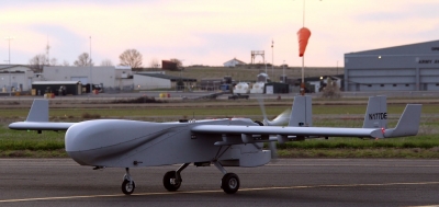
On September 21 and 22, from an airstrip at the Eastern Oregon Regional Airport, the ArcticShark flew its first instruments, hefting aloft on its 22-foot wings a modest payload of 18 pounds. Still, it was a landmark moment, a proof-of-concept, for the ARM Climate Research Facility’s latest and biggest unmanned aerial system (UAS).
The bulky and bulb-nosed ArcticShark is 14 feet long, weighs 650 pounds, and has a four-bladed prop the size of a ceiling fan. But compared to truly large conventional aerial platforms that require an onboard pilot, UAS aircraft offer a lot of advantages to atmospheric scientists.
They are lighter, smaller, and less expensive to buy and fly. Their range is not as great, but they fly low and slow enough to capture a small area of atmospheric data in greater detail. These denser, more precise sets of data are desirable for experiments and models in which grid scales are getting increasingly fine.
UAS planes can’t go as high as tethered balloons or soak up as much data, but they are untethered and can be programmed to fly precise patterns while piloted from the ground, combing the air for data on temperature, humidity, and other important measures.
The ArcticShark is rated as a Group 3 (moderate) size UAS. Propelled by a rotary engine, it has a range of eight hours and can climb to 18,000 feet. Those are greater capabilities than smaller platforms, but still modest enough to retain economies of scale.
A Modest Payload
During the maiden instrumented flights in September, the miniature instruments were fitted into a cargo bay the size of two picnic coolers. Fitted very carefully.
To maintain the ArcticShark’s aerial stability, “we have to match the weights up,” says ArcticShark UAS flight operations technician Peter Carroll.
That 18-pound payload was just a fraction of the aircraft’s 100-pound cargo capacity, but was a good place to start. It also reflects one problem facing all UAS platforms for atmospheric science: Shrinking instruments to UAS sizes is an ongoing challenge.
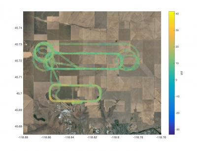
In data terms, the first flights were as modest as the weight of the cargo. Over two days, in three patterned runs up to about 2,500 feet, the ArcticShark pulled in data on down-looking infrared temperature, ambient temperature, wind velocities, and ambient relative humidity.
A ‘Fine Start’
At this point, the limited number of instruments makes the aircraft a kind of “Model A,” says Mike Hubbell, chief pilot and director of operations for the ARM Aerial Facility (AAF), a U.S. Department of Energy’s airborne observatory.
But of course greatness and progress arose from the platform of that early automobile. The ArcticShark crew gathered in early October for an operation meeting, and all agreed that the maiden flights were a fine start.
That included AAF manager Beat Schmid, an atmospheric scientist at Pacific Northwest National Laboratory (PNNL) in southeastern Washington state. “We’ve been saying all year we would fly a mini-payload,” he says, “and we did.”
The temperature and humidity data looked good, adds Schmid, though “we are struggling a little with making sense of the wind measurements.” There is also a minor issue with electromagnetic interference, or vibrations, within the tiny confines of the payload bay.
Data from the Skies
Data were stored onboard the ArcticShark and downloaded upon landing. But during the flights, a version of these measurements was also streamed to a UAS command-and-control center in a small wheeled trailer parked by the airstrip, its roof arrayed with antennae and satellite dishes.
Inside the trailer, near storage racks for the aircraft’s wings and tail section, two pilots sit at a pair of monitors and guide the plane with keyboards. To their left is a work station used by scientists to monitor on-site data.
For the September flights, PNNL engineers Albert Mendoza and Matt Newburn monitored and downloaded data. They passed it on to Fan Mei, a PNNL atmospheric scientist.
PNNL is home base for the ArcticShark’s operations staff, including Hubbell, Carroll, Clayton Eveland, and Michael Crocker. On most days, the UAS itself is parked in the small Pasco hangar, about a 20-minute drive from the PNNL campus in Richland, Washington.
Back in her office, Mei analyzed data from the maiden flights, including measurements from an infrared thermometer (IRT), a radiation pyrometer.
“The one in the ArcticShark measures the narrowband radiating temperature of the ground surface,” she says. “Scientists monitor land surface temperature because the warmth rising off Earth’s landscapes influences, and is influenced by, our world’s weather and climate patterns.”
A week after the tests, Schmid peered inside the compact scientific payload bay of the ArcticShark and was pleased. “We think it’s highly successful,” he says, “and right on schedule.”
The ARM Climate Research Facility is a DOE Office of Science user facility. The ARM Facility is operated by nine DOE national laboratories, including Pacific Northwest National Laboratory.
Follow Us:


Keep up with the Atmospheric Observer
Updates on ARM news, events, and opportunities delivered to your inbox
ARM User Profile
ARM welcomes users from all institutions and nations. A free ARM user account is needed to access ARM data.


