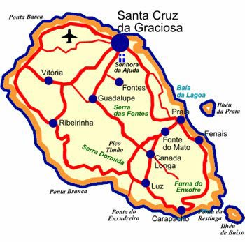
Team Scouts Graciosa Island for 2009 Mobile Facility Deployment Site
Published: 30 April 2008

Indications from a scouting trip by the ARM Mobile Facility (AMF) science and operations management team are that an excellent site for the 2009 deployment may have been found. From April 8 through April 16, the team traveled to Graciosa Island in the Azores to scout sites for the Clouds, Aerosol, and Precipitation in the Marine Boundary Layer (CAP-MBL) field campaign.
On the upwind side of the island they located a site near the airport about 500 meters from the coastline. In addition to a buoy located just offshore that measures sea surface temperature, the team noted that the National Oceanic and Atmospheric Administration (NOAA) is operating flux instrumentation at Mt. Pico, which is visible from Graciosa. Supplementary observations made above the boundary layer from Mt. Pico would greatly benefit the data set collected at the airport. Finally, the team had productive meetings with in-country hosts from the University of the Azores and the Portugal Meteorological Institute. These contacts will be extremely valuable as deployment planning continues in the coming year.
The ARM Climate Research Facility is a DOE Office of Science user facility. The ARM Facility is operated by nine DOE national laboratories, including .
Keep up with the Atmospheric Observer
Updates on ARM news, events, and opportunities delivered to your inbox
ARM User Profile
ARM welcomes users from all institutions and nations. A free ARM user account is needed to access ARM data.


