

ARM Fiscal Year 2025 Radar Plan Outlines Operational, Data Priorities
Published: 13 February 2025
The Atmospheric Radiation Measurement (ARM) User Facility evaluates its activities each fiscal year to make sure they provide the most benefit and impact to the scientific community within budget and staffing constraints.
ARM’s newest radar plan outlines how engineering and data staff are prioritizing their time and effort in fiscal year 2025 (FY2025) to help ensure continued operational excellence of ARM’s radars. ARM radar data team lead Ya-Chien Feng and engineering team lead Iosif “Andrei” Lindenmaier head the list of 14 authors.
The plan outlines ARM’s FY2025 priorities in the following areas:
- radar preparation and installation
- radar maintenance and testing
- radar operations and data monitoring
- data quality analysis and processing
- radar data products.
In addition, the plan summarizes related activities from the previous fiscal year.
Radar Operations
Radar work continues at ARM’s three fixed-location atmospheric observatories: the Southern Great Plains (SGP), North Slope of Alaska (NSA), and Eastern North Atlantic (ENA). Ka-Band ARM Zenith Radar (KAZR) operations remain a key focus at the SGP, NSA, and ENA in FY2025, just as they were in FY2024.
Other primary tasks planned at the fixed observatories in FY2025 include upgrades, maintenance, and testing of the X-Band Scanning ARM Precipitation Radar (XSAPR) at the ENA and the second-generation Ka/W-Band Scanning ARM Cloud Radar (KASACR2/WSACR2) at the NSA.
Another ongoing focus for ARM is radar operations at mobile deployments.
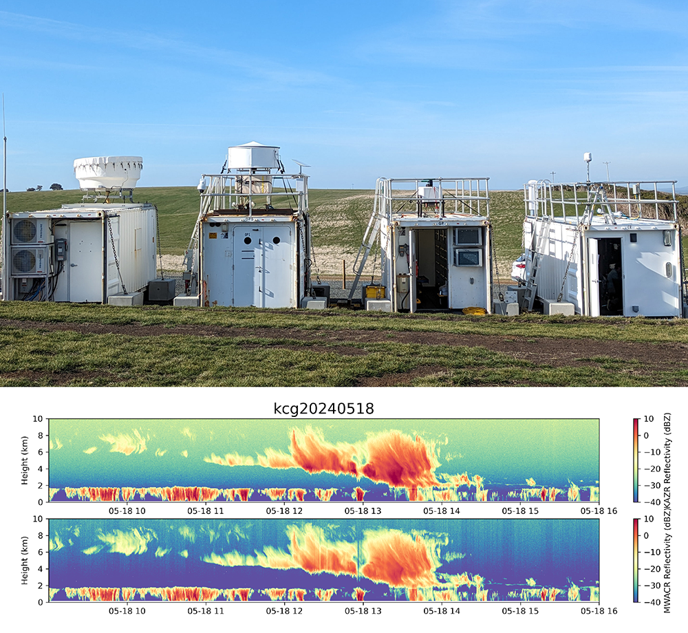
In February 2024, ARM completed KAZR and KASACR/WSACR operations in La Jolla, California, when the Eastern Pacific Cloud Aerosol Precipitation Experiment (EPCAPE) ended. Two months later, a KAZR and Marine W-Band ARM Cloud Radar (MWACR) started collecting official data in Tasmania for the Cloud And Precipitation Experiment at kennaook (CAPE-k).
ARM also prepared a KAZR to be installed in Baltimore, Maryland, for the Coast-Urban-Rural Atmospheric Gradient Experiment (CoURAGE). The KAZR is now running as part of CoURAGE, which began in December 2024 and will go through November 2025.
In Alabama, ARM installed a KAZR and Ka/X-Band Scanning ARM Cloud Radar (KASACR/XSACR) as part of the Bankhead National Forest (BNF) long-term mobile observatory, which opened in October 2024. Installation of a second-generation C-Band Scanning ARM Precipitation Radar (CSAPR2) at the BNF was delayed to early FY2025.
For nearly all of FY2025, ARM will operate radars as part of its three mobile deployments. CAPE-k will finish in mid-September 2025, CoURAGE will end in late November, and the BNF is planned to operate for at least five years.
Radar Data
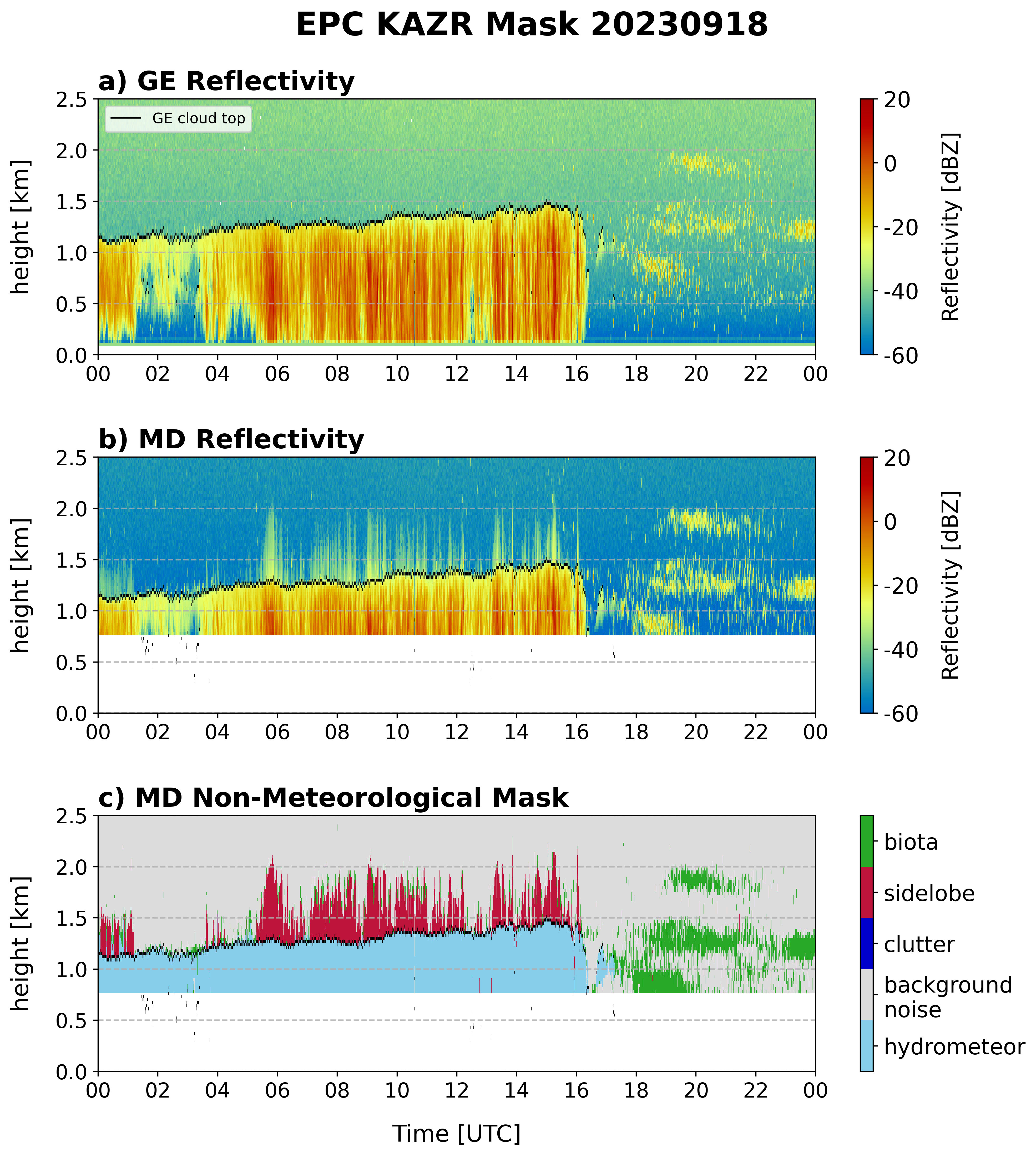
In FY2024, the radar data team worked to advance the processing of b1-level data. Data at the b1 level have undergone calibration, correction, and quality control processes beyond ARM’s standard quality checks and corrections. They have a higher level of processing than a1-level data, which have calibration factors applied and converted to geophysical units.
Scientists can now use b1-level radar data released in FY2024 from the 2019–2020 Multidisciplinary Drifting Observatory for the Study of Arctic Climate (MOSAiC) expedition and the 2021–2022 TRacking Aerosol Convection interactions ExpeRiment (TRACER) around Houston, Texas. (FY2024 progress on b1-level data for radar deployments is detailed on Page 6 of the radar plan.)
In FY2025, b1-level radar data are slated for release from the SGP, NSA, and ENA. In addition, b1-level data are expected from EPCAPE and the 2021–2023 Surface Atmosphere Integrated Field Laboratory (SAIL) campaign near Crested Butte, Colorado.
ARM has plans in FY2025 to summarize and document the standard procedures it uses to ensure the quality of its b1-level radar data. Currently, such information appears in individual technical reports for each campaign that has b1-level data.
The plan also discusses priority activities connected to ARM’s cloud and precipitation value-added products. These higher-order data products are analyzed and processed to make ARM measurements more usable for purposes such as atmospheric process studies or model evaluation. ARM’s group of science translators and product developers will continue to focus on releasing existing products at new sites and reprocessing previously released data.
Meanwhile, ARM data analysts are focused on developing sub-cloud ice precipitation retrievals and data epochs (well-characterized, calibrated measurements) on cellular mesoscale organizations, expanding convective cell tracking efforts, and using KAZR spectra in new ways.
Provide Your Feedback
The FY2025 radar plan is now available for you to read on ARM.gov. If you have questions or feedback on the plan, please send them to Feng or Lindenmaier.
Follow Us:


Keep up with the Atmospheric Observer
Updates on ARM news, events, and opportunities delivered to your inbox
ARM User Profile
ARM welcomes users from all institutions and nations. A free ARM user account is needed to access ARM data.


