

2024 AMS Presentations Featuring ARM Data
Published: 3 February 2024
![]() The 2024 American Meteorological Society (AMS) Annual Meeting will be held from January 28 to February 1 in Baltimore, Maryland, and online. With more than 5,000 attendees expected, the meeting might feel overwhelming. We make it easy for you to find ARM-relevant science, meet up with colleagues, and discover new connections during the event.
The 2024 American Meteorological Society (AMS) Annual Meeting will be held from January 28 to February 1 in Baltimore, Maryland, and online. With more than 5,000 attendees expected, the meeting might feel overwhelming. We make it easy for you to find ARM-relevant science, meet up with colleagues, and discover new connections during the event.
Below is a list of ARM-related AMS meeting highlights (all times Eastern). Information is subject to change; please check the AMS Annual Meeting website for the most up-to-date information. Follow us on X (formerly Twitter) and Facebook for a real-time guide to relevant activities using the hashtags #ARMAMS and #AMS2024.
Discover more ARM-related presentations and posters, as well as sessions, talks, and posters related to Atmospheric System Research (ASR).
Add your presentation to be featured on the ARM or ASR presentation web pages.
Attending AMS in person? Make sure to visit the ARM booth (#333) in the AMS exhibition hall. There you can view facility materials and meet with ARM representatives.
U.S. Department of Energy (DOE) Updates
- Panel Discussion 6C: Advancing and Innovating Equitable Climate Solutions: Baltimore’s Social–Environmental Collaborative
Tuesday, January 30, 10:45 a.m.–noon, Baltimore Convention Center, Ballroom II (400 Level)
Session Chair: Gaige Hunter Kerr, George Washington University
- Session J7: Engagement Opportunities and New Horizons in Observational Research: Career Pathway Discussions
Tuesday, January 30, 1:45–3 p.m., Baltimore Convention Center, Room 341
Reported ARM and ASR-related presentation:- J7.1: Observational Atmospheric Research at the Department of Energy – ARM and ASR. Sally McFarlane and Shaima Nasiri, DOE
- Agency Updates Session: DOE’s Urban Integrated Field Laboratories: Improving Climate and Environmental Predictability for Urban Regions
Thursday, February 1, 12:15–1:15 p.m., Hilton Baltimore Inner Harbor, Holiday 6 (Second Floor)
Session Co-Chairs: Bob Vallario, Gerald L. Geernaert, and Sally McFarlane, DOE
Check out ARM-Related Presentations:
Town Halls
Related Interagency Town Halls
- Earth System Predictability across Time Scales from Weather to Climate
Monday, January 29, 12:15–1:15 p.m., Hilton Baltimore Inner Harbor, Holiday 6 (Second Floor)
Primary Contact: Glen S. Romine, NCAR
Presenters: Everette David Joseph and Jadwiga H. Richter, NCAR
Invited Presentations
Please note: On average, each presentation is scheduled to run no longer than 15 minutes, so the full session times are listed below for planning purposes.
- J9B.6: Surface-Based Remote Sensing of Ice Formation and Growth Processes in Mixed-Phase Clouds. Pavlos Kollias, Stony Brook University.
Wednesday, January 31, 8:30–10 a.m., Baltimore Convention Center, Room 329
- 13A.2: Combining Tried-and-True Strategies for Reducing Uncertainties in Aerosol-Cloud-Precipitation-Radiation Interactions in Climate Models. Ann M. Fridlind, NASA Goddard Institute for Space Studies.
Thursday, February 1, 8:30–10 a.m., Baltimore Convention Center, Room 328
Featured Field Campaign Presentations
Coast-Urban-Rural Atmospheric Gradient Experiment (CoURAGE)
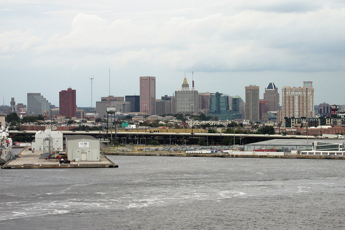
The Coast-Urban-Rural Atmospheric Gradient Experiment (CoURAGE) is expected to start in December 2024 and run through November 2025 in Baltimore, Maryland. The campaign will study surface-atmosphere interactions around Baltimore to see how they influence the city’s climate. With data provided from multiple sites in and around the city, CoURAGE will be able to document the degree to which different surface conditions around the region can change Baltimore’s atmospheric environment.
CoURAGE will contribute to the Baltimore Social-Environmental Collaborative (BSEC), one of four recently funded DOE Urban Integrated Field Laboratories.
- ePOSTER SESSION—15th Conference on Environment and Health ePosters
Monday, January 29, 3–3:40 p.m., Baltimore Convention Center, Hall E (100 Level)
Reported CoURAGE presentation:- E9: Improving our Understanding of Urban Boundary Layer Dynamics in Baltimore. Ben Ahlswede, Pennsylvania State University.
- PANEL DISCUSSION—6C: Advancing and Innovating Equitable Climate Solutions: Baltimore’s Social–Environmental Collaborative
Tuesday, January 30, 10:45 a.m.–noon, Baltimore Convention Center, Ballroom II (400 Level)
Session Chair: Gaige Hunter Kerr, George Washington University
- POSTER SESSION—15th Conference on Environment and Health
Wednesday, January 31, 3–4:30 p.m., Baltimore Convention Center, Hall E (100 Level)
Reported CoURAGE presentation:- 721: CoURAGE! An Atmospheric Campaign to Advance Our Understanding of Urban Climate and Air Quality in Complex Regional Environments. Kenneth J. Davis, Pennsylvania State University.
- AGENCY UPDATES SESSION—DOE’s Urban Integrated Field Laboratories: Improving Climate and Environmental Predictability for Urban Regions
Thursday, February 1, 12:15–1:15 p.m., Hilton Baltimore Inner Harbor, Holiday 6 (Second Floor)
Session Co-Chairs: Bob Vallario, Gerald L. Geernaert, and Sally McFarlane, DOE
Eastern Pacific Cloud Aerosol Precipitation Experiment (EPCAPE)
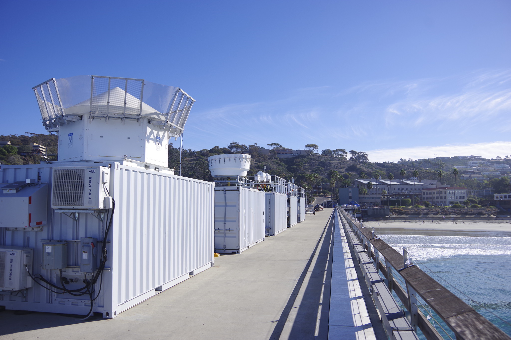
The Eastern Pacific Cloud Aerosol Precipitation Experiment (EPCAPE), which kicked off in La Jolla, California, in February 2023 and is set to close operations in February 2024, will explore aerosol indirect effects on stratocumulus clouds to help improve their representation in earth system models. EPCAPE includes the deployment of the first ARM Mobile Facility on the Ellen Browning Scripps Memorial Pier and a scanning cloud radar on Mount Soledad less than a mile inland.
As part of EPCAPE, researchers will also investigate how pollution from the nearby Los Angeles metropolitan area affects marine aerosols and, by extension, the clouds near San Diego.
- POSTER SESSION—16th Symposium on Aerosol Cloud Climate Interactions Posters I
Monday, January 29, 3:30–4:30 p.m., Baltimore Convention Center, Hall E (100 Level)
Reported EPCAPE presentation:- 260: Cloud-Processed Aerosol Size Distribution Signatures in Coastal Marine Stratocumulus during EPCAPE. Jeramy L. Dedrick, Scripps Institution of Oceanography at the University of California San Diego.
- POSTER SESSION—Kuo-Nan Liou Symposium Poster Session
Tuesday, January 30, 3–4:30 p.m., Baltimore Convention Center, Hall E (100 Level)
Reported EPCAPE presentation:- 281: ARM Radar Calibrations and Cloud Variation during the EPCAPE Field Campaign. Min Deng, Brookhaven National Laboratory.
- POSTER SESSION—16th Symposium on Aerosol Cloud Climate Interactions Posters II
Tuesday, January 30, 3–4:30 p.m., Baltimore Convention Center, Hall E (100 Level)
Reported EPCAPE presentation:- 479: Size-Resolved Submicron Aerosol Organic Functional Group Measurements during Low-Cloud Conditions in EPCAPE 2023. Christian Pelayo, Scripps Institution of Oceanography at the University of California San Diego.
- POSTER SESSION—New and Emerging Measurement Methods in Cloud and Precipitation Research
Wednesday, January 31, 3–4:30 p.m., Baltimore Convention Center, Hall E (100 Level)
Reported EPCAPE presentation:- 806: Ka/W/G-band Simultaneous Radar Observations of Marine Clouds during the Eastern Pacific Cloud Aerosol Precipitation Experiment. Juan Socuellamos, NASA Jet Propulsion Laboratory.
- POSTER SESSION—Regional Air Quality (Poster Session I)
Wednesday, January 31, 3–4:30 p.m., Baltimore Convention Center, Hall E (100 Level)
Reported EPCAPE presentation:- 604: Aerosol Size Distribution Modes and their Potential Source Contribution Functions in the Southern California Coastal Region during EPCAPE 2023. Ian Marroquin, Scripps Institution of Oceanography at the University of California San Diego.
- ORAL SESSION—16: Aerosol-Cloud Interactions in Warm Clouds II
Thursday, February 1, 4:30–6 p.m., Baltimore Convention Center, Room 329
Reported EPCAPE presentation:- 16.3: OH Burst Measurement: Online Direct-to-Reagent System to Measure OH Formation by Cloud Processed Ambient
Aerosols. Suzanne Paulson, University of California Los Angeles.
- 16.3: OH Burst Measurement: Online Direct-to-Reagent System to Measure OH Formation by Cloud Processed Ambient
Surface Atmosphere Integrated Field Laboratory (SAIL)
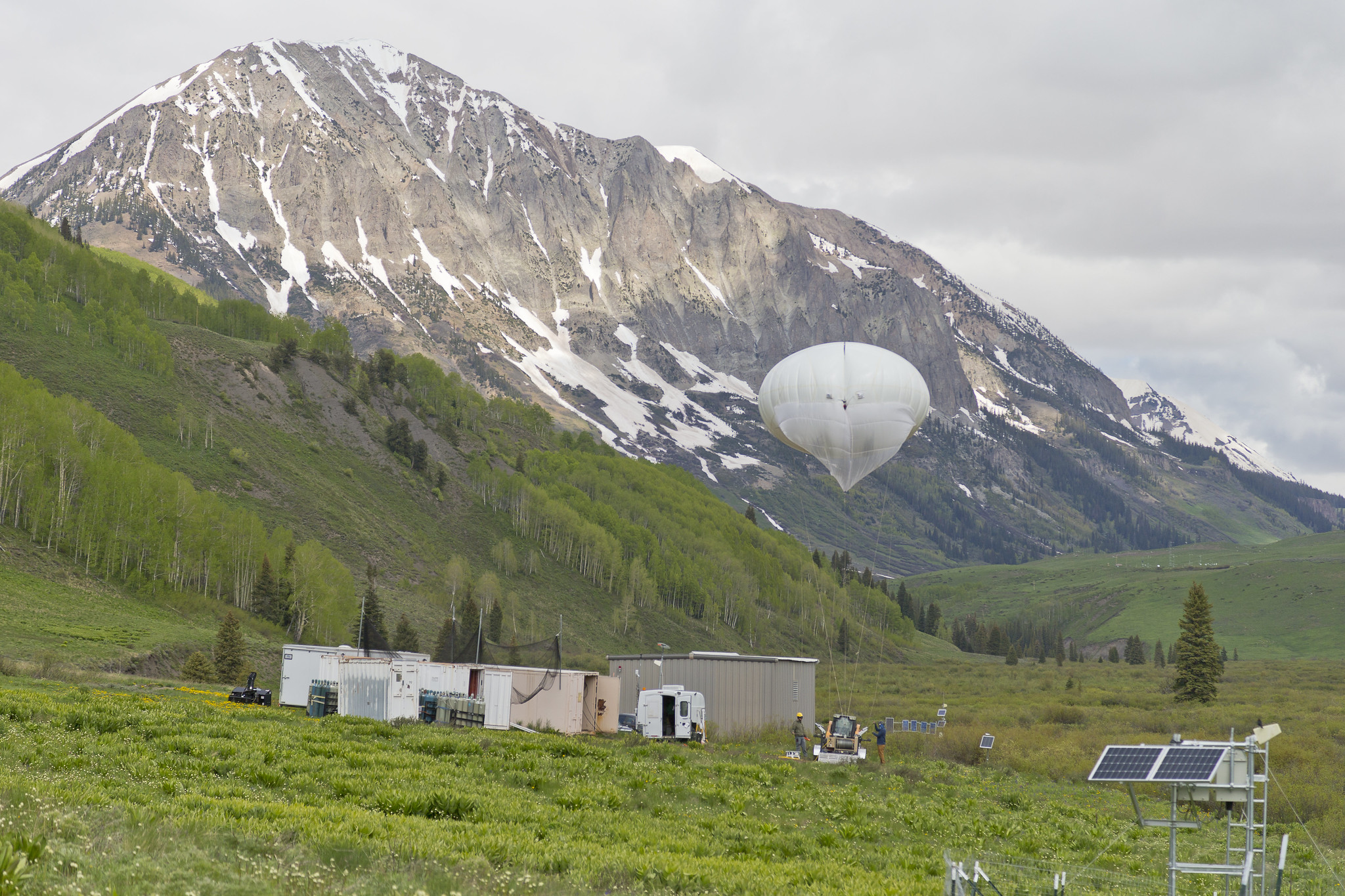
The Surface Atmosphere Integrated Field Laboratory (SAIL) field campaign, which operated from September 2021 to June 2023, took place in the 300-square-kilometer (116-square-mile) East River Watershed near Crested Butte, Colorado. As part of SAIL, a portable ARM observatory provided valuable atmospheric data that researchers can use to develop detailed measurements of mountainous water-cycle processes pertaining to the Colorado River, which supplies water for 40 million people in the Western United States.
By using data from SAIL and co-located fieldwork, researchers from national laboratories, universities, research centers, and agencies are gaining an atmosphere-through-bedrock understanding of mountainous water cycles.
- ORAL SESSION—4C: Surface-Atmosphere Exchanges, Interactions and Feedbacks III
Monday, January 29, 4:30–6 p.m., Baltimore Convention Center, Room 339
Reported SAIL presentation:- 4C.5: Aerosol Interactions in Complex Mountainous Terrain. Allison C. Aiken, Los Alamos National Laboratory.
SAIL’s lead scientist, Daniel Feldman, is chairing the following SAIL-related AMS sessions:
- ORAL SESSION—13A: Field and Remote Sensing Observations and Modeling of Hydrology and its Change in High-Altitude Complex Terrain
Thursday, February 1, 8:30–10 a.m., Baltimore Convention Center, Rooms 318/319
Reported SAIL presentations:- 13A.1: Multi-Modal Chemical Characterization of Brown Carbon in Atmosphere and Snowpack from the Colorado Rockies. Steven Sharpe, Purdue University.
- 13A.3: Evaluation of wintertime precipitation estimates and forecasts in the Mountains of Colorado. Janice L. Bytheway, NOAA.
- 13A.4: Warm Season Precipitation Estimation and Analysis in the Colorado East River Basin during SPLASH and SAIL field experiments. Sounak Kumar Biswas, Colorado State University.
- POSTER SESSION—Field and Remote Sensing Observations and Modeling of Hydrology and its Change in High-altitude Complex Terrain
Thursday, February 1, 3–4:30 p.m., Baltimore Convention Center, Hall E (100 Level)
Reported SAIL presentations:- 821: Particle Imaging on a Budget: Observations and Lessons Learned from OSCRE Deployments at SAIL and SPLASH.
Aaron D. Kennedy, University of North Dakota. - 822: Summary of and Selected Highlights from the Surface Atmosphere Integrated Field Laboratory (SAIL) Field Campaign. Daniel Feldman, Lawrence Berkeley National Laboratory.
- 821: Particle Imaging on a Budget: Observations and Lessons Learned from OSCRE Deployments at SAIL and SPLASH.
TRacking Aerosol Convection interactions ExpeRiment (TRACER)

The TRacking Aerosol Convection interactions ExpeRiment (TRACER), which ran from October 2021 through September 2022, provided convective cloud observations with high space and time resolution over a broad range of environmental and aerosol conditions in the Houston, Texas, region.
As part of TRACER, ARM deployed a portable observatory southeast of downtown Houston, a scanning precipitation radar south of downtown, and an ancillary site southwest of the city, where tethered balloon systems were launched. Together, these ARM measurements are helping researchers better understand the variability of aerosols and meteorology between the urban Houston area and surrounding rural environments.
- POSTER SESSION—Observations and Instrumentation
Sunday, January 28, 6:30–8:30 p.m., Baltimore Convention Center, Hall E (100 Level)
Reported TRACER presentation:- S193: Influence of Soil Moisture on Rainfall and Cloud Properties in the Houston Area during TRACER. Jacob Lee Fields,
Ohio State University/Brookhaven National Laboratory.
- S193: Influence of Soil Moisture on Rainfall and Cloud Properties in the Houston Area during TRACER. Jacob Lee Fields,
- ORAL SESSION—Session 2: Coastal Meteorological Processes II
Monday, January 29, 10:45 a.m.–noon, Baltimore Convention Center, Room 343
Reported TRACER presentation:- 2.3: The Variability of the Houston Sea-Breeze: Analysis of Planetary Boundary-Layer Height Evolution and Characteristics from Observations During TRACER-CUBIC. Michelle Rose Spencer, Cooperative Institute for Severe and High-Weather Research and Operations at the University of Oklahoma.
- ORAL SESSION—J3B: Aerosol-Cloud Interaction in Deep Convection II
Joint session with the 16th Symposium on Aerosol Cloud Climate Interactions and First Symposium on Cloud Physics
Monday, January 29, 1:45–3 p.m., Baltimore Convention Center, Room 329
Reported TRACER presentation:- J3B.3: Causal Estimation of Aerosol Effects on Rainfall Core Depth in Isolated Deep Convective Clouds: Findings from TRACER.
Dié Wang, Brookhaven National Laboratory.
- J3B.3: Causal Estimation of Aerosol Effects on Rainfall Core Depth in Isolated Deep Convective Clouds: Findings from TRACER.
- ORAL SESSION—3B: Greenhouse Gases II
Monday, January 29, 1:45–3 p.m., Baltimore Convention Center, Rooms 321/322
Reported TRACER presentation:- 3B.5: Exploring the Influence of Local Urban and Industrial Carbon-Based Pollutant Sources on Total Column Concentration Enhancements in Houston, Texas during TRACER. Elizabeth Spicer, University of Oklahoma.
- POSTER SESSION—16th Symposium on Aerosol Cloud Climate Interactions Posters I
Monday, January 29, 3:30–4:30 p.m., Baltimore Convention Center, Hall E (100 Level)
Reported TRACER presentations:- 253: Modeling Study of the Effects of Urbanization on Deep Convection, Precipitation, and Lightning Around the Houston Metropolitan Area. Takamichi Iguchi, University of Maryland.
- 255: Properties of Convective Outflow from Isolated Cells Observed during TRACER. Michael P. Jensen, Brookhaven National Laboratory.
- ORAL SESSION—J4B: Aerosol-Cloud Interaction in Deep Convection III
Joint session with the 16th Symposium on Aerosol Cloud Climate Interactions and First Symposium on Cloud Physics
Monday, January 29, 4:30–6 p.m., Baltimore Convention Center, Room 329
Reported TRACER presentations:- J4B.2: Investigating Aerosols Interaction in Convective Clouds during the TRACER / ESCAPE Field Campaigns in Houston, Texas. Ali Al Jabri, University of Oklahoma.
- J4B.5: Transport of Urban and Rural Boundary Layer Aerosol Particles within Deep Convective Storm Systems. Charles Davis, Colorado State University.
- J4B.6: Sensitivity of Convective Cloud Properties and Evolution to Model Physics during ESCAPE: Case Studies. Yishi Hu, University of Oklahoma.
- ORAL SESSION—5: Analysis and Modeling of Coastal Urban Environments
Tuesday, January 30, 8:30–10 a.m., Baltimore Convention Center, Room 343
Reported TRACER presentations:- 5.1: Evaluating the Vertical Structure of Near-Coastal Meteorological Phenomena Around Urban Regions Using Uncrewed Aircraft Systems. Gijs de Boer, NOAA.
- 5.2: Modelling & Observations of Anthropogenic Influences on Thunderstorms in Coastal Urban Houston. Jean Carlos Pena, University at Albany.
- ORAL SESSION—J9B: Atmospheric Ice-Nucleating Particles and Ice Formation Processes in Clouds II
Joint session with the 16th Symposium on Aerosol Cloud Climate Interactions and First Symposium on Cloud Physics
Wednesday, January 31, 8:30–10 a.m., Baltimore Convention Center, Room 329
Reported TRACER presentation:- J9B.4: Analysis of Houston Aerosols as Ice Nucleating Particles During TRACER. Seth A. Thompson, Texas A&M University.
- ORAL SESSION—10: Advances in Cumulus Convection Measurements, Parameterization, and Modeling II
Wednesday, January 31, 10:45 a.m.–noon, Hilton Baltimore Inner Harbor, Key 12 (Second Floor)
Reported TRACER presentation:- 10.1: The TRACER Field Campaign: Measurement and Modeling Activities for the Study of Aerosol-Convection Interactions. Michael P. Jensen, Brookhaven National Laboratory.
- ORAL SESSION—10: Integrating Uncrewed Aerial Systems (UAS) into Meteorology
Wednesday, January 31, 10:45 a.m.–noon, Baltimore Convention Center, Room 341
Reported TRACER presentation:- 10.3: Uncertainty Estimation for Small-UAS Wind Measurements in Calm and Dynamic Environments. Robert Sasse, University of Colorado Boulder.
- POSTER SESSION—Regional Air Quality (Poster Session I)
Wednesday, January 31, 3–4:30 p.m., Baltimore Convention Center, Hall E (100 Level)
Reported TRACER presentation:- 602: Intercomparison of Tropospheric and Total Column Ozone of TRACER-AQ Data Sets with EPIC on DSCOVR Satellite.
Samuel Flusche, St. Edward’s University.
- 602: Intercomparison of Tropospheric and Total Column Ozone of TRACER-AQ Data Sets with EPIC on DSCOVR Satellite.
- ORAL SESSION—12: New Open Tools in the Atmospheric and Oceanographic Sciences
Wednesday, January 31, 4:30–6 p.m., Baltimore Convention Center, Room 324
Reported TRACER presentation:- 12.4: Enabling Post-campaign Processing of Single Particle Soot Photometer (SP2) Data Using PySP2 and Dask.
Robert C. Jackson, Argonne National Laboratory.
- 12.4: Enabling Post-campaign Processing of Single Particle Soot Photometer (SP2) Data Using PySP2 and Dask.
Follow Us:


Keep up with the Atmospheric Observer
Updates on ARM news, events, and opportunities delivered to your inbox
ARM User Profile
ARM welcomes users from all institutions and nations. A free ARM user account is needed to access ARM data.


