
New Cloud Radar Products Available for CACTI Campaign
Published: 19 January 2021
The Atmospheric Radiation Measurement (ARM) user facility released new cloud radar value-added products (VAPs) from the Cloud, Aerosol, and Complex Terrain Interactions (CACTI) field campaign.
With these VAPs, scientists can more easily use corrected observations from ARM scanning and vertically pointing cloud radars, and they can access hydrometeor masks and cloud boundaries from the entire CACTI campaign.
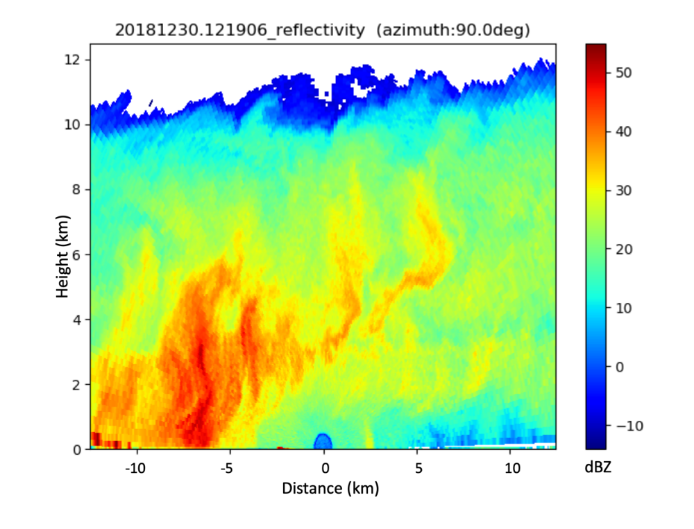
Scanning ARM Cloud Radar Grid (SACRGRID) VAPs provide radar moments from range-height indicator (RHI) scans on a Cartesian grid. Two SACRGRID products are available from CACTI: KASACRGRIDRHI, for the Ka-band SACR; and XSACRGRIDRHI, for the X-band SACR.
The gridded radar moments include reflectivity, mean Doppler velocity, spectral width, signal-to-noise ratio, differential phase, and—for the X-band radar—differential reflectivity and specific attenuation. The moments are accompanied by a significant detection mask, linear depolarization ratio, and copolar-to-crosspolar correlation coefficient.
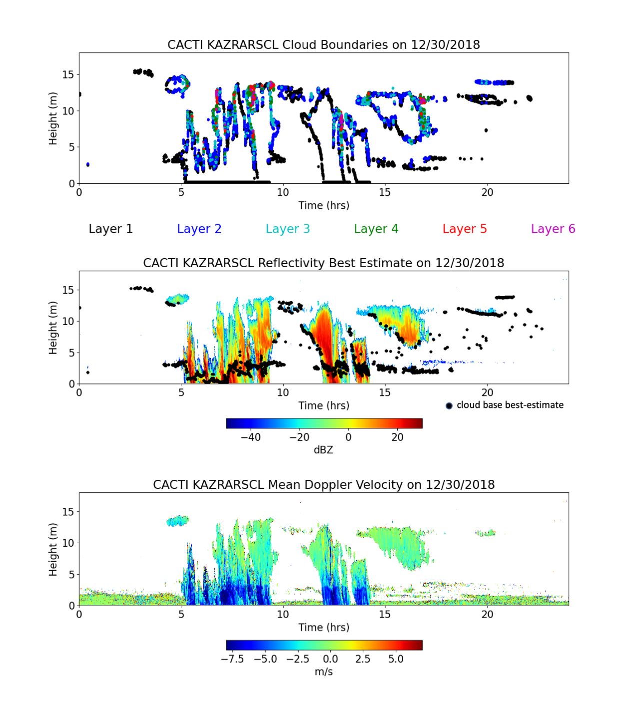
Also available from CACTI is the Ka-Band ARM Zenith Radar Active Remote Sensing of CLouds (KAZRARSCL) VAP. KAZRARSCL provides best-estimate radar reflectivities, mean Doppler velocities and spectral widths in time and height, along with a significant detection mask and best-estimate cloud base. The VAP also provides cloud boundaries for up to 10 cloud layers.
KAZRARSCL, KASACRGRIDRHI, and XSACRGRIDRHI cover the entire CACTI deployment from October 2018 through April 2019 in Argentina’s Sierras de Córdoba mountain range.
KASACRGRIDRHI and XSACRGRIDRHI remap crosswind-RHI scans to a Cartesian grid. The crosswind-RHI scans consist of multiple consecutive horizon-to-horizon scans (elevations 0–180 degrees). Six azimuth angle sweeps are scanned at the CACTI site for the SACRs.
Input data are b1-level calibrated and corrected RHI data. A nearest neighbor algorithm is used for gridding, with a censor mask applied. Additional details on these pre-processing details may be found in CACTI b1-level radar processing documentation. Gaseous attenuation correction is also applied for the Ka-band radars—KASACR and KAZR—before gridding.
The output is a single netCDF file containing all aforementioned calibrated radar moments remapped onto a two-dimensional (2D) Cartesian grid.
Currently, KASACRGRIDRHI and XSACRGRIDRHI are evaluation products.
The established KAZRARSCL VAP combines KAZR, micropulse lidar, and ceilometer observations, and sounding and microwave radiometer input observations. It is run using b1-level input data.
Reflectivity is corrected for near-field antenna effects and gaseous attenuation. KAZR radar modes are optimally merged and non-hydrometeor clutter returns are removed to provide best-estimate reflectivity. Mean Doppler velocities are dealiased to correct periods when observed velocities exceeded the radar’s maximum (Nyquist) velocity and were incorrectly recorded.
Up to 10 layers of cloud boundaries (cloud base and cloud top) are determined by combining KAZR and micropulse lidar observations.
This product is available in daily files. It provides vertical profiles every four seconds from approximately 160 meters above ground level up to 18 kilometers, with 30-meter height resolution.
KASACRGRIDRHI and XSACRGRIDRHI will move to production after their evaluation period.
For more information about these VAPs, go to the web pages for KASACRGRIDRHI, XSACRGRIDRHI, and KAZRARSCL.
For questions, feedback, or to report data problems, please contact Meng Wang or Scott Giangrande for KASACRGRIDRHI and XSACRGRIDRHI, and Karen Johnson or Scott Giangrande for KAZRARSCL.
KASACRGRIDRHI data can be referenced as doi:10.5439/1645175 and XSACRGRIDRHI data as doi:10.5439/1645174.
KAZRARSCL data can be referenced as doi:10.5439/1228768.
Access the data sets for KASACRGRIDRHI, XSACRGRIDRHI, and KAZRARSCL in the ARM Data Center. (Go here to create an account to download the data.)
Follow Us:


Keep up with the Atmospheric Observer
Updates on ARM news, events, and opportunities delivered to your inbox
ARM User Profile
ARM welcomes users from all institutions and nations. A free ARM user account is needed to access ARM data.


