Reprocessed Raman Lidar Data Now Available
Published: 11 March 2013

- cloud mask
- depolarization ratio
- extinction coefficient
- backscatter coefficient
- attenuation flag.
As part of this reprocessing effort, the RLPROFMERGE, RLPROFASR, RLPROFEXT, and RLPROFDEP VAPs for Darwin have also been reprocessed with the extended height range, and RLPROFMR has been reprocessed using improved calibration parameters.
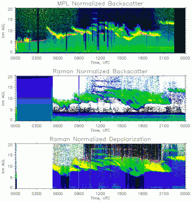
The reprocessed Raman lidar data improve the detection of cirrus and anvil clouds in the upper tropical troposphere as demonstrated in the comparison of Raman and micropulse lidars (see figure).
More information is available at the VAP web page. To access these data, log in to the Data Archive. (Go here to request an account.)
The ARM Climate Research Facility is a DOE Office of Science user facility. The ARM Facility is operated by nine DOE national laboratories, including .
Keep up with the Atmospheric Observer
Updates on ARM news, events, and opportunities delivered to your inbox
ARM User Profile
ARM welcomes users from all institutions and nations. A free ARM user account is needed to access ARM data.


