

New Lidar Evaluation Data Product Provides Aerosol Features
Published: 28 March 2025
A new evaluation value-added product (VAP) from the Atmospheric Radiation Measurement (ARM) User Facility uses lidar to identify aerosol features, including the top and base heights of the aerosol layers.
The Lidar AEROsol feature MASK (LIDARAEROMASK) VAP leverages the remote sensing capability of ARM lidar systems. It provides information on the vertical distributions of aerosols over an ARM site. Users can obtain vertical profiles of major aerosol layer occurrence frequencies and their associated bulk properties, such as aerosol particle size and shape, as indicated by the color ratio and linear depolarization, respectively.
The first release of this VAP uses high-spectral-resolution lidar (HSRL) data to create the product HSRLAEROMASK. In the future, micropulse and Raman lidar data will also be used to produce the VAP.
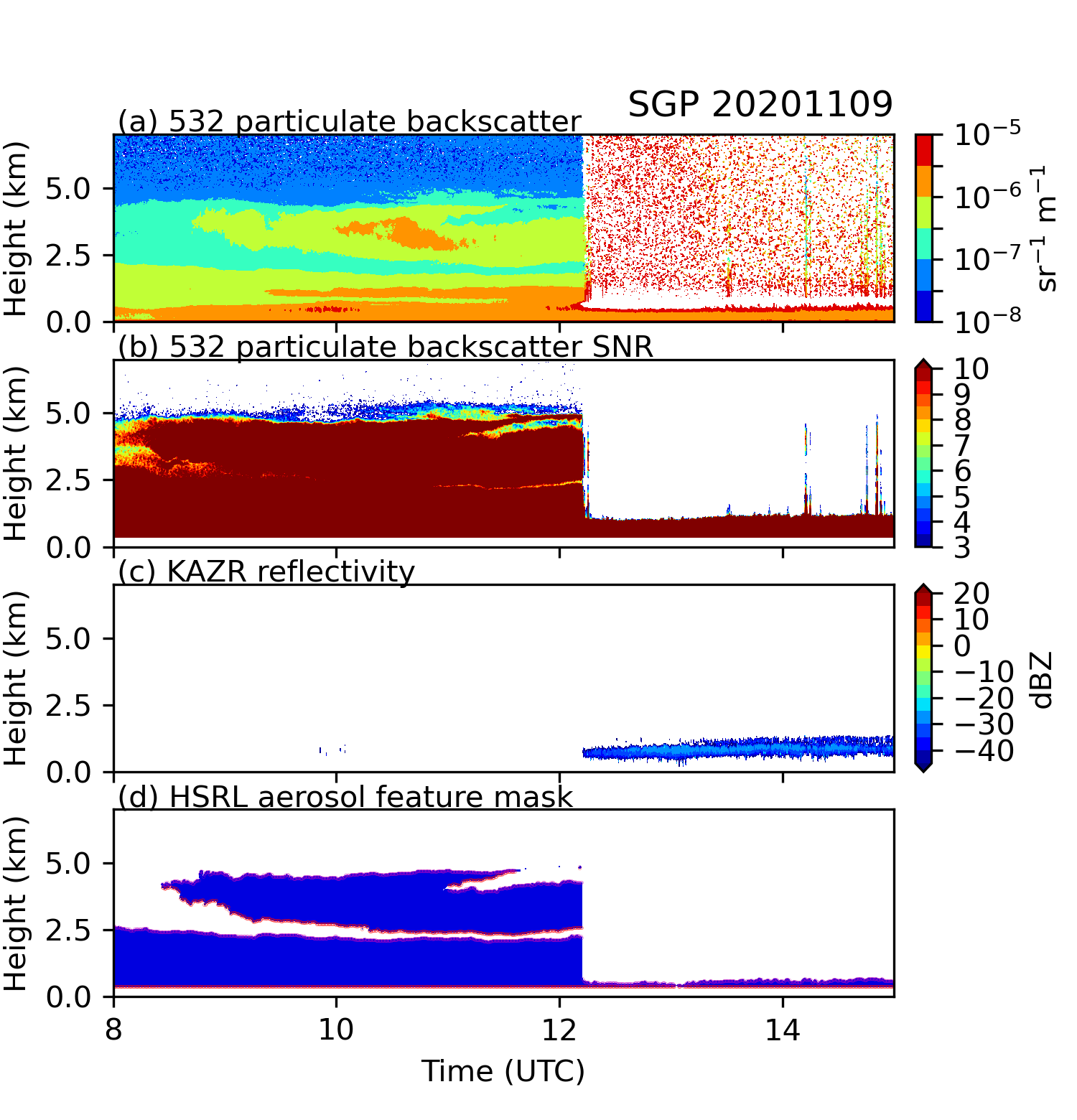
The LIDARAEROMASK VAP adopted the feature identification approach used in the Raman Lidar Profiles – Feature detection and Extinction (RLPROF-FEX) VAP (Thorsen et al. 2015). For aerosol layer identifications, scattering ratio threshold profiles are calculated based on signal-to-noise ratio and molecular backscatter. Values above these thresholds indicate scattering from aerosol particles. The VAP consists of a binary field of aerosol masks at a 30-meter vertical resolution and 30-second temporal resolution, as well as aerosol-layer top and base heights for up to 10 layers.
The VAP includes aerosol feature masks during cloudy and cloud-free conditions. However, during cloudy conditions, aerosol masks only extend to the lowest echo height in input data from the Active Remote Sensing of CLouds (ARSCL) VAP.
HSRLAEROMASK evaluation data are available from the Southern Great Plains atmospheric observatory’s S01 supplemental site near Lamont, Oklahoma, from August 25, 2020, to May 12, 2021. Users can also access evaluation data from the main site of the Surface Atmosphere Integrated Field Laboratory (SAIL) campaign at Gothic, Colorado, from September 15, 2021, to June 15, 2023. The files are in netCDF format. The evaluation data will move to production in the future.
More information about HSRLAEROMASK is available on the LIDARAEROMASK web page.
Scientists can use the HSRLAEROMASK data now. Access the data in the ARM Data Center. (To download the data, first create an ARM account.)
For questions or feedback to help improve this evaluation product, please contact Peng Wu.
Data can be referenced as doi:10.5439/2008200.
Reference: Thorsen TJ, Q Fu, RK Newsom, DD Turner, and JM Comstock. 2015. “Automated Retrieval of Cloud and Aerosol Properties from the ARM Raman Lidar. Part I: Feature Detection.” Journal of Atmospheric and Oceanic Technology, 32(11), https://doi.org/10.1175/JTECH-D-14-00150.1
Follow Us:


Keep up with the Atmospheric Observer
Updates on ARM news, events, and opportunities delivered to your inbox
ARM User Profile
ARM welcomes users from all institutions and nations. A free ARM user account is needed to access ARM data.


