First Look at AMIE Radiosonde Data
Published: 7 October 2011

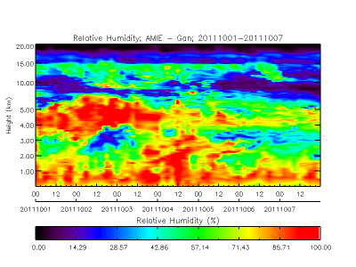
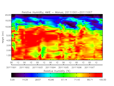
 One of the key components of the AMIE campaign is the launch of frequent radiosondes (weather balloons) to explore the evolution of the temperature and moisture fields as the MJO develops over the Indian Ocean and propagates across the Pacific. A key hypothesis of the campaign is that the deep convection can only organize into an MJO cycle when there is a large-scale moist layer in the middle atmosphere. In the first week of the AMIE campaign, the local AMF2 staff at Gan and the local observers at Manus have been kept quite busy launching 8 radiosondes per day (that’s one radiosonde every 3 hours!) to get these key observations. The plots below illustrate the results of their dedicated labor, showing the detailed vertical and temporal structure of the moisture field at the two sites.
At Gan, there is quite a bit of vertical and temporal variability in the moisture field. At all times the relative humidity near the surface is quite large, but how high those moist levels penetrate into the middle atmosphere varies from day to day based on both horizontal and vertical transport of moisture. In contrast, Manus shows less variability, with high relative humidities throughout most of the troposphere during the week.
This is just a sneak peek at some of the exciting observations we’ll get over the next 6 months from the AMIE campaign!
The ARM Climate Research Facility is a DOE Office of Science user facility. The ARM Facility is operated by nine DOE national laboratories, including .
Keep up with the Atmospheric Observer
Updates on ARM news, events, and opportunities delivered to your inbox
ARM User Profile
ARM welcomes users from all institutions and nations. A free ARM user account is needed to access ARM data.


